Riverton East Topo Map Wyoming
To zoom in, hover over the map of Riverton East
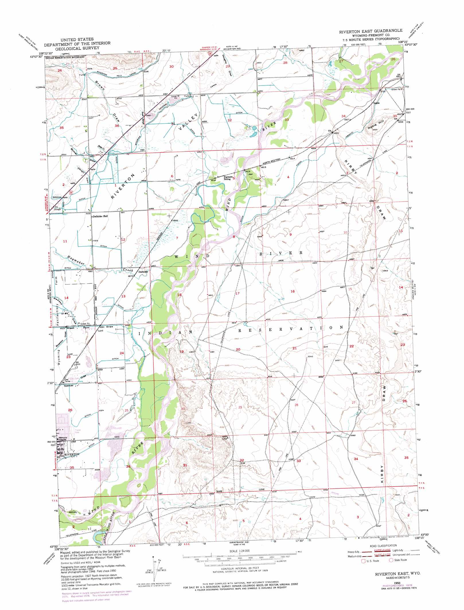
USGS Topo Quad 43108a3 - 1:24,000 scale
| Topo Map Name: | Riverton East |
| USGS Topo Quad ID: | 43108a3 |
| Print Size: | ca. 21 1/4" wide x 27" high |
| Southeast Coordinates: | 43° N latitude / 108.25° W longitude |
| Map Center Coordinates: | 43.0625° N latitude / 108.3125° W longitude |
| U.S. State: | WY |
| Filename: | o43108a3.jpg |
| Download Map JPG Image: | Riverton East topo map 1:24,000 scale |
| Map Type: | Topographic |
| Topo Series: | 7.5´ |
| Map Scale: | 1:24,000 |
| Source of Map Images: | United States Geological Survey (USGS) |
| Alternate Map Versions: |
Riverton East WY 1950, updated 1952 Download PDF Buy paper map Riverton East WY 1950, updated 1975 Download PDF Buy paper map Riverton East WY 1950, updated 1979 Download PDF Buy paper map Riverton East WY 2012 Download PDF Buy paper map Riverton East WY 2015 Download PDF Buy paper map |
1:24,000 Topo Quads surrounding Riverton East
Harris Bridge |
Mexican Pass Sw |
Mexican Pass Se |
Bonneville Sw |
Bonneville |
Ocean Lake |
Lost Wells Butte |
Riverton Ne |
Hidden Valley |
Shoshoni |
Pavillion Se |
Riverton West |
Riverton East |
Indian Butte |
Fuller Reservoir |
Hudson |
Arapahoe |
Arapahoe Ne |
Alkali Butte |
Campbell Ridge |
Lander Se |
Ninemile Hill |
Bringolf Ranch |
Sand Draw |
Blue Gulch |
> Back to 43108a1 at 1:100,000 scale
> Back to 43108a1 at 1:250,000 scale
> Back to U.S. Topo Maps home
Riverton East topo map: Gazetteer
Riverton East: Canals
Riverton Number 2 Canal elevation 1547m 5075′Riverton East: Guts
Ice Slough elevation 1524m 5000′Rush Slough elevation 1511m 4957′
Riverton East: Mines
Midvale Irrigation Pit elevation 1517m 4977′Riverton East: Streams
Botts Creek elevation 1506m 4940′Haymaker Creek elevation 1476m 4842′
Little Wind River elevation 1494m 4901′
Riverton East: Summits
Neble Hill elevation 1504m 4934′Riverton East: Valleys
Albright Draw elevation 1507m 4944′Brown Draw elevation 1506m 4940′
Doughty Draw elevation 1495m 4904′
Gibbons Draw elevation 1512m 4960′
Kirby Draw elevation 1464m 4803′
Madden Draw elevation 1497m 4911′
Prison Farm Draw elevation 1482m 4862′
Riverton Draw elevation 1502m 4927′
Shriner Draw elevation 1504m 4934′
Spencer Draw elevation 1482m 4862′
Riverton East digital topo map on disk
Buy this Riverton East topo map showing relief, roads, GPS coordinates and other geographical features, as a high-resolution digital map file on DVD: