Big Southern Butte Topo Map Idaho
To zoom in, hover over the map of Big Southern Butte
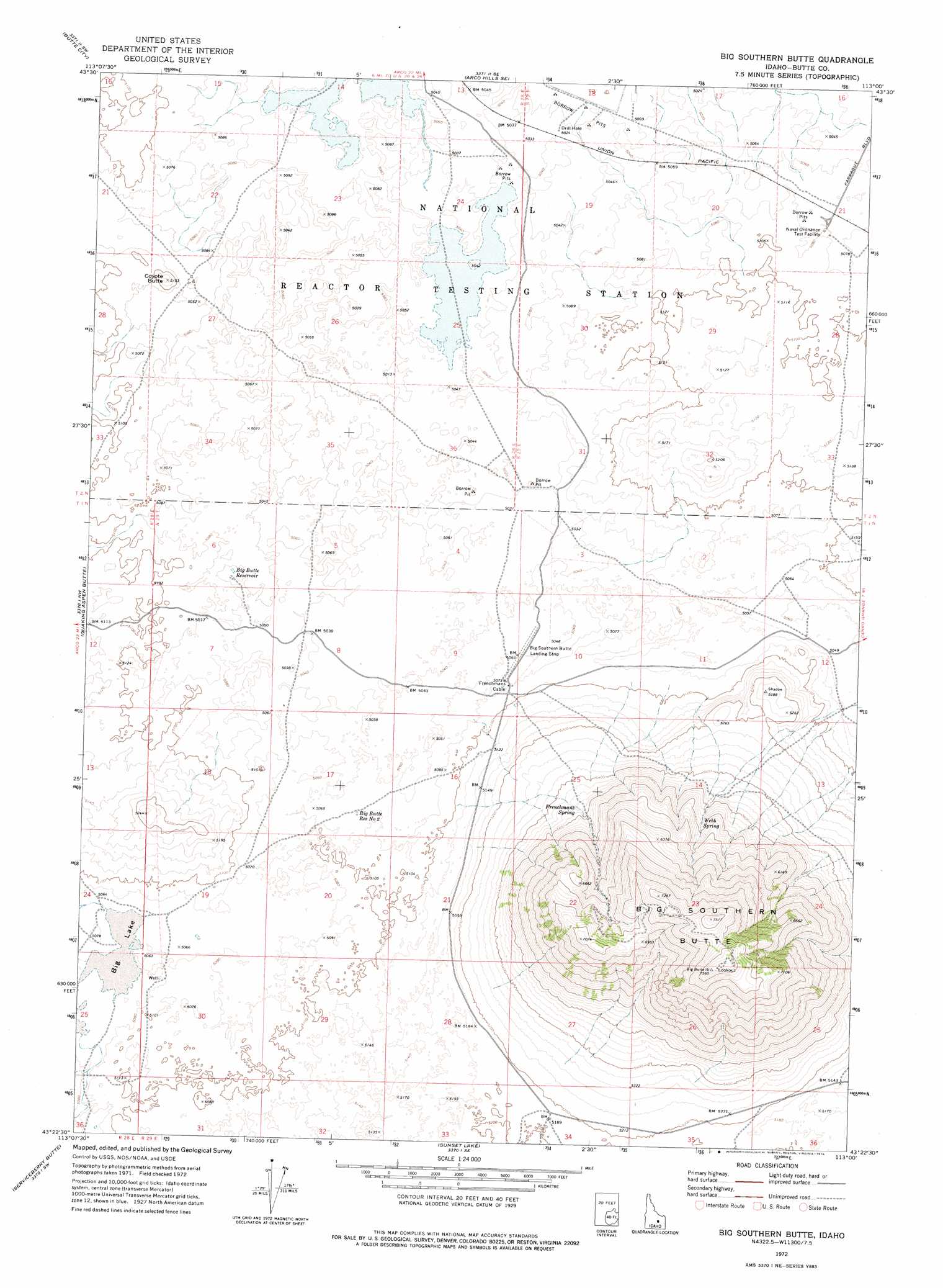
USGS Topo Quad 43113d1 - 1:24,000 scale
| Topo Map Name: | Big Southern Butte |
| USGS Topo Quad ID: | 43113d1 |
| Print Size: | ca. 21 1/4" wide x 27" high |
| Southeast Coordinates: | 43.375° N latitude / 113° W longitude |
| Map Center Coordinates: | 43.4375° N latitude / 113.0625° W longitude |
| U.S. State: | ID |
| Filename: | o43113d1.jpg |
| Download Map JPG Image: | Big Southern Butte topo map 1:24,000 scale |
| Map Type: | Topographic |
| Topo Series: | 7.5´ |
| Map Scale: | 1:24,000 |
| Source of Map Images: | United States Geological Survey (USGS) |
| Alternate Map Versions: |
Big Southern Butte ID 1972, updated 1976 Download PDF Buy paper map Big Southern Butte ID 2010 Download PDF Buy paper map Big Southern Butte ID 2013 Download PDF Buy paper map |
1:24,000 Topo Quads surrounding Big Southern Butte
Arco North |
Arco Hills |
Howe Peak |
Circular Butte 3 Nw |
Circular Butte 3 Ne |
Arco South |
Butte City |
Arco Hills Se |
Circular Butte 3 Sw |
Circular Butte 3 Se |
Fingers Butte |
Quaking Aspen Butte |
Big Southern Butte |
Scoville |
Atomic City |
Pratt Butte |
Serviceberry Butte |
Sunset Lake |
Rock Butte |
Lava Lake Reservoir |
Bear Park East |
Antelope Lake |
Split Top |
Coffee Point |
Coffee Point Ne |
> Back to 43113a1 at 1:100,000 scale
> Back to 43112a1 at 1:250,000 scale
> Back to U.S. Topo Maps home
Big Southern Butte topo map: Gazetteer
Big Southern Butte: Airports
Big Southern Butte Airport elevation 1543m 5062′Big Southern Butte: Lakes
Big Lake elevation 1549m 5082′Big Southern Butte: Reservoirs
Big Butte Reservoir elevation 1543m 5062′Big Butte Reservoir Number Two elevation 1547m 5075′
Big Southern Butte: Springs
Frenchmans Spring elevation 1681m 5515′Webb Spring elevation 1748m 5734′
Big Southern Butte: Summits
Big Butte elevation 2296m 7532′Big Southern Butte elevation 2273m 7457′
Coyote Butte elevation 1568m 5144′
Big Southern Butte digital topo map on disk
Buy this Big Southern Butte topo map showing relief, roads, GPS coordinates and other geographical features, as a high-resolution digital map file on DVD: