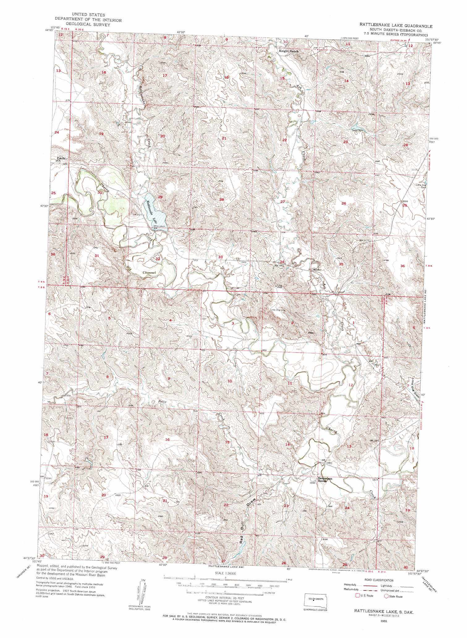
Rattlesnake Lake Topo Map South Dakota
To zoom in, hover over the map of Rattlesnake Lake
USGS Topo Quad 44101f6 - 1:24,000 scale
| Topo Map Name: | Rattlesnake Lake |
| USGS Topo Quad ID: | 44101f6 |
| Print Size: | ca. 21 1/4" wide x 27" high |
| Southeast Coordinates: | 44.625° N latitude / 101.625° W longitude |
| Map Center Coordinates: | 44.6875° N latitude / 101.6875° W longitude |
| U.S. State: | SD |
| Filename: | o44101f6.jpg |
| Download Map JPG Image: | Rattlesnake Lake topo map 1:24,000 scale |
| Map Type: | Topographic |
| Topo Series: | 7.5´ |
| Map Scale: | 1:24,000 |
| Source of Map Images: | United States Geological Survey (USGS) |
| Alternate Map Versions: |
Rattlesnake Lake SD 1955, updated 1956 Download PDF Buy paper map Rattlesnake Lake SD 2012 Download PDF Buy paper map Rattlesnake Lake SD 2015 Download PDF Buy paper map |
1:24,000 Topo Quads surrounding Rattlesnake Lake
Bessie Butte |
Bull Creek 2 Ne |
Diermier Ranch |
Miller Dam |
High Elk Hill Nw |
Chasing Hawk Draw |
Red Scaffold |
Longbrake Ranch |
Sears Dam |
High Elk Hill Sw |
Dead Horse Draw |
Bridger Ne |
Rattlesnake Lake |
Rattlesnake Lake Ne |
Cherry Creek Nw |
Bridger |
Bridger Se |
Rattlesnake Lake Sw |
Rattlesnake Lake Se |
Cherry Creek |
Hilland Nw |
Hartley |
Milesville |
Murray Draw |
Middle Draw |
> Back to 44101e1 at 1:100,000 scale
> Back to 44100a1 at 1:250,000 scale
> Back to U.S. Topo Maps home
Rattlesnake Lake topo map: Gazetteer
Rattlesnake Lake: Dams
Jesse Dam elevation 628m 2060′Little Dog Dam elevation 670m 2198′
Rattlesnake Lake: Reservoirs
Rattlesnake Lake elevation 586m 1922′Rattlesnake Lake: Streams
Ash Creek elevation 561m 1840′Felix Creek elevation 555m 1820′
Old Channel Cherry Creek elevation 574m 1883′
Rattlesnake Creek elevation 573m 1879′
Rattlesnake Lake: Valleys
Red Bull Draw elevation 561m 1840′Rattlesnake Lake digital topo map on disk
Buy this Rattlesnake Lake topo map showing relief, roads, GPS coordinates and other geographical features, as a high-resolution digital map file on DVD:
Eastern North Dakota & Eastern South Dakota
Buy digital topo maps: Eastern North Dakota & Eastern South Dakota