Forest Topo Map Maine
To zoom in, hover over the map of Forest
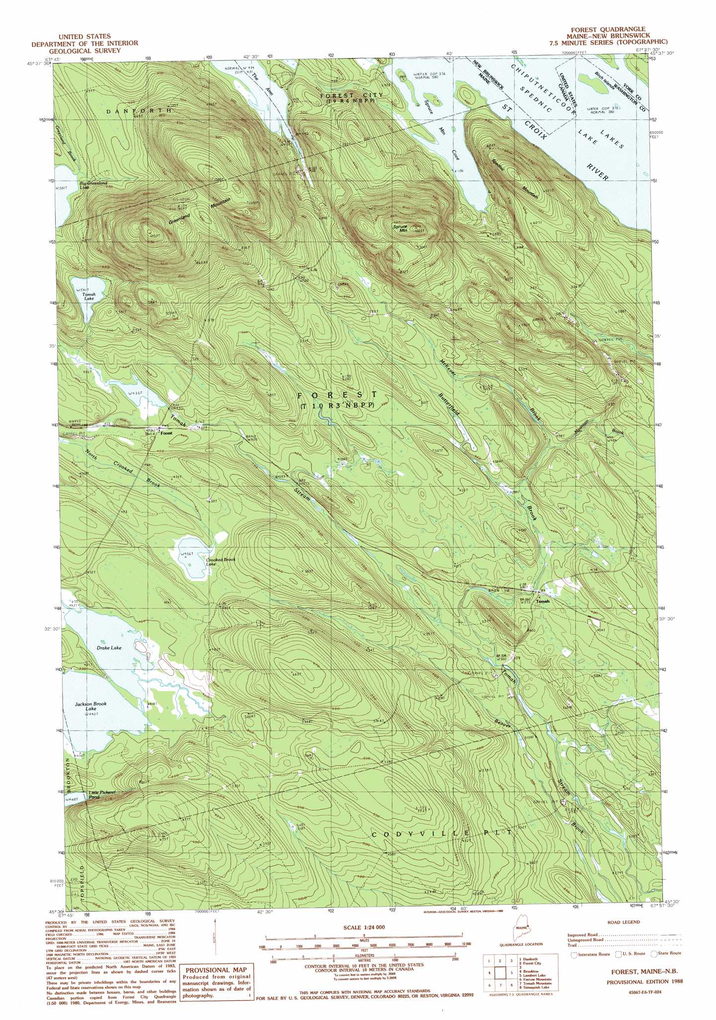
USGS Topo Quad 45067e6 - 1:24,000 scale
| Topo Map Name: | Forest |
| USGS Topo Quad ID: | 45067e6 |
| Print Size: | ca. 21 1/4" wide x 27" high |
| Southeast Coordinates: | 45.5° N latitude / 67.625° W longitude |
| Map Center Coordinates: | 45.5625° N latitude / 67.6875° W longitude |
| U.S. State: | ME |
| Filename: | o45067e6.jpg |
| Download Map JPG Image: | Forest topo map 1:24,000 scale |
| Map Type: | Topographic |
| Topo Series: | 7.5´ |
| Map Scale: | 1:24,000 |
| Source of Map Images: | United States Geological Survey (USGS) |
| Alternate Map Versions: |
Forest ME 1988, updated 1988 Download PDF Buy paper map Forest ME 2011 Download PDF Buy paper map Forest ME 2014 Download PDF Buy paper map |
1:24,000 Topo Quads surrounding Forest
Haynesville |
Orient |
|||
Jimmey Mountain |
Danforth |
Forest City |
||
Stetson Mountain |
Brookton |
Forest |
Lambert Lake |
Vanceboro |
Dill Hill |
Farrow Mountain |
Tomah Mountain |
Simsquish Lake |
Loon Bay |
Scraggly Lake |
Oxbrook Lakes |
Waite |
Toman Ridge |
Kellyland |
> Back to 45067e1 at 1:100,000 scale
> Back to 45066a1 at 1:250,000 scale
> Back to U.S. Topo Maps home
Forest topo map: Gazetteer
Forest: Bays
Spruce Mountain Cove elevation 116m 380′Forest: Islands
Birch Islands elevation 116m 380′Forest: Lakes
Big Greenland Lake elevation 177m 580′Crooked Brook Lake elevation 139m 456′
Drake Lake elevation 134m 439′
Jackson Brook Lake elevation 134m 439′
Little Pickerel Pond elevation 142m 465′
Tomah Lake elevation 165m 541′
Forest: Populated Places
Forest elevation 134m 439′Tomah elevation 115m 377′
Forest: Streams
Butterfield Brook elevation 92m 301′McKever Brook elevation 121m 396′
Mountain Brook elevation 131m 429′
Forest: Summits
Greenland Mountain elevation 363m 1190′Spednic Mountain elevation 229m 751′
Spruce Mountain elevation 308m 1010′
Forest digital topo map on disk
Buy this Forest topo map showing relief, roads, GPS coordinates and other geographical features, as a high-resolution digital map file on DVD:
Maine, New Hampshire, Rhode Island & Eastern Massachusetts
Buy digital topo maps: Maine, New Hampshire, Rhode Island & Eastern Massachusetts