Jimmey Mountain Topo Map Maine
To zoom in, hover over the map of Jimmey Mountain
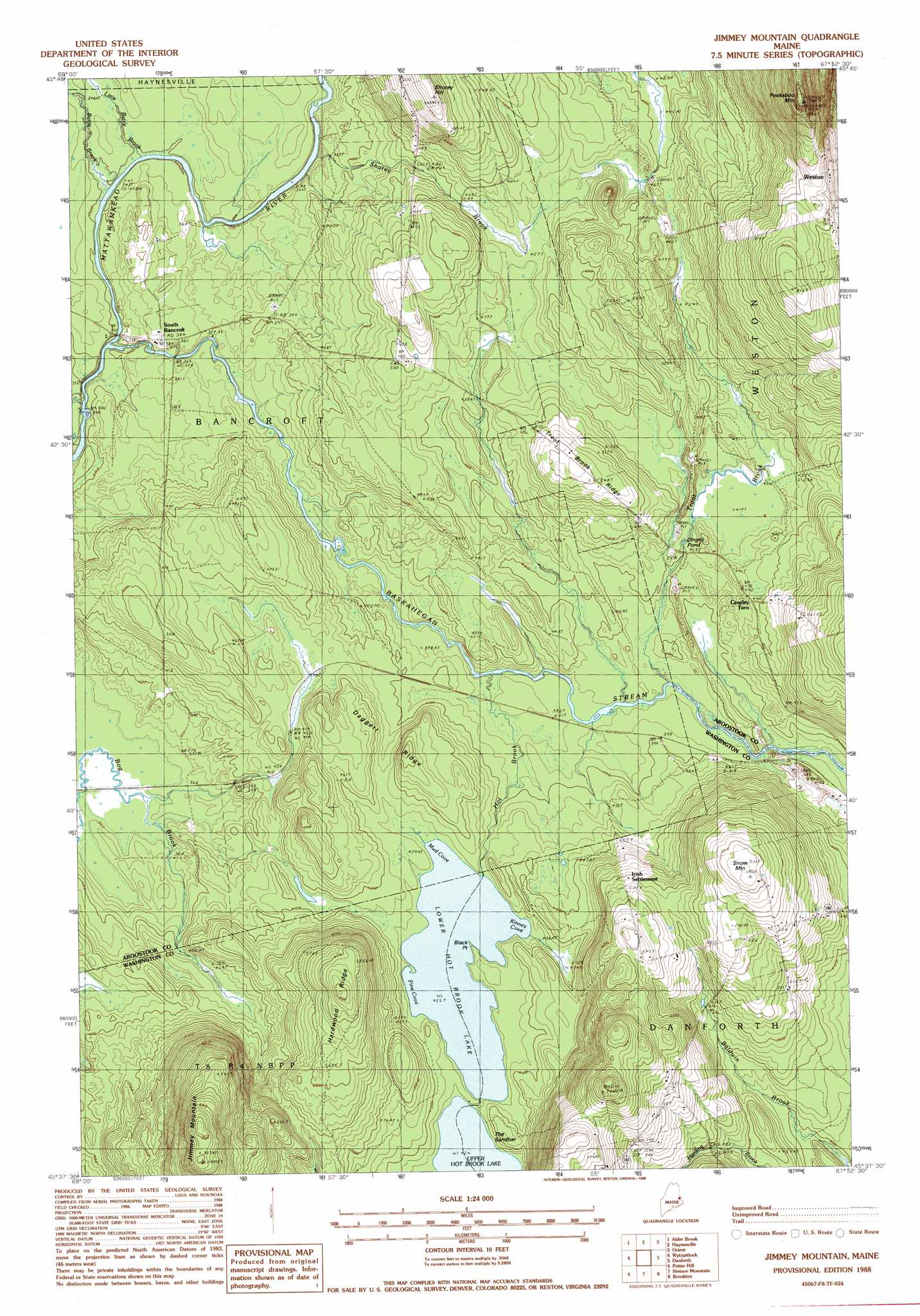
USGS Topo Quad 45067f8 - 1:24,000 scale
| Topo Map Name: | Jimmey Mountain |
| USGS Topo Quad ID: | 45067f8 |
| Print Size: | ca. 21 1/4" wide x 27" high |
| Southeast Coordinates: | 45.625° N latitude / 67.875° W longitude |
| Map Center Coordinates: | 45.6875° N latitude / 67.9375° W longitude |
| U.S. State: | ME |
| Filename: | o45067f8.jpg |
| Download Map JPG Image: | Jimmey Mountain topo map 1:24,000 scale |
| Map Type: | Topographic |
| Topo Series: | 7.5´ |
| Map Scale: | 1:24,000 |
| Source of Map Images: | United States Geological Survey (USGS) |
| Alternate Map Versions: |
Danforth NW ME 1975, updated 1980 Download PDF Buy paper map Jimmey Mountain ME 1988, updated 1988 Download PDF Buy paper map Jimmey Mountain ME 2011 Download PDF Buy paper map Jimmey Mountain ME 2014 Download PDF Buy paper map |
1:24,000 Topo Quads surrounding Jimmey Mountain
Mattawamkeag Lake |
Monument Brook |
Ten Mile Lake |
North Amity |
|
Wytopitlock Lake |
Alder Brook |
Haynesville |
Orient |
|
Reed Pond |
Wytopitlock |
Jimmey Mountain |
Danforth |
Forest City |
Kingman |
Potter Hill |
Stetson Mountain |
Brookton |
Forest |
Springfield |
Bowers Mountain |
Dill Hill |
Farrow Mountain |
Tomah Mountain |
> Back to 45067e1 at 1:100,000 scale
> Back to 45066a1 at 1:250,000 scale
> Back to U.S. Topo Maps home
Jimmey Mountain topo map: Gazetteer
Jimmey Mountain: Bars
The Sandbar elevation 129m 423′Jimmey Mountain: Bays
Kinney Cove elevation 128m 419′Mud Cove elevation 128m 419′
Pine Cove elevation 129m 423′
Jimmey Mountain: Capes
Black Point elevation 128m 419′Jimmey Mountain: Lakes
Dingey Pond elevation 132m 433′Lower Hot Brook Lake elevation 128m 419′
Jimmey Mountain: Populated Places
Cropley Turn elevation 130m 426′Irish Settlement elevation 171m 561′
South Bancroft elevation 116m 380′
Weston elevation 232m 761′
Jimmey Mountain: Ridges
Daggett Ridge elevation 151m 495′Hardwood Ridge elevation 207m 679′
Trout Brook Ridge elevation 169m 554′
Jimmey Mountain: Streams
Baldwin Brook elevation 130m 426′Baskahegan Stream elevation 103m 337′
Battle Brook elevation 104m 341′
Hot Brook elevation 112m 367′
Little Battle Brook elevation 105m 344′
Shorey Brook elevation 106m 347′
Trout Brook elevation 117m 383′
Jimmey Mountain: Summits
Jimmey Mountain elevation 273m 895′Peekaboo Mountain elevation 269m 882′
Shorey Hill elevation 205m 672′
Snow Mountain elevation 220m 721′
Jimmey Mountain digital topo map on disk
Buy this Jimmey Mountain topo map showing relief, roads, GPS coordinates and other geographical features, as a high-resolution digital map file on DVD:
Maine, New Hampshire, Rhode Island & Eastern Massachusetts
Buy digital topo maps: Maine, New Hampshire, Rhode Island & Eastern Massachusetts