Polar Topo Map Wisconsin
To zoom in, hover over the map of Polar
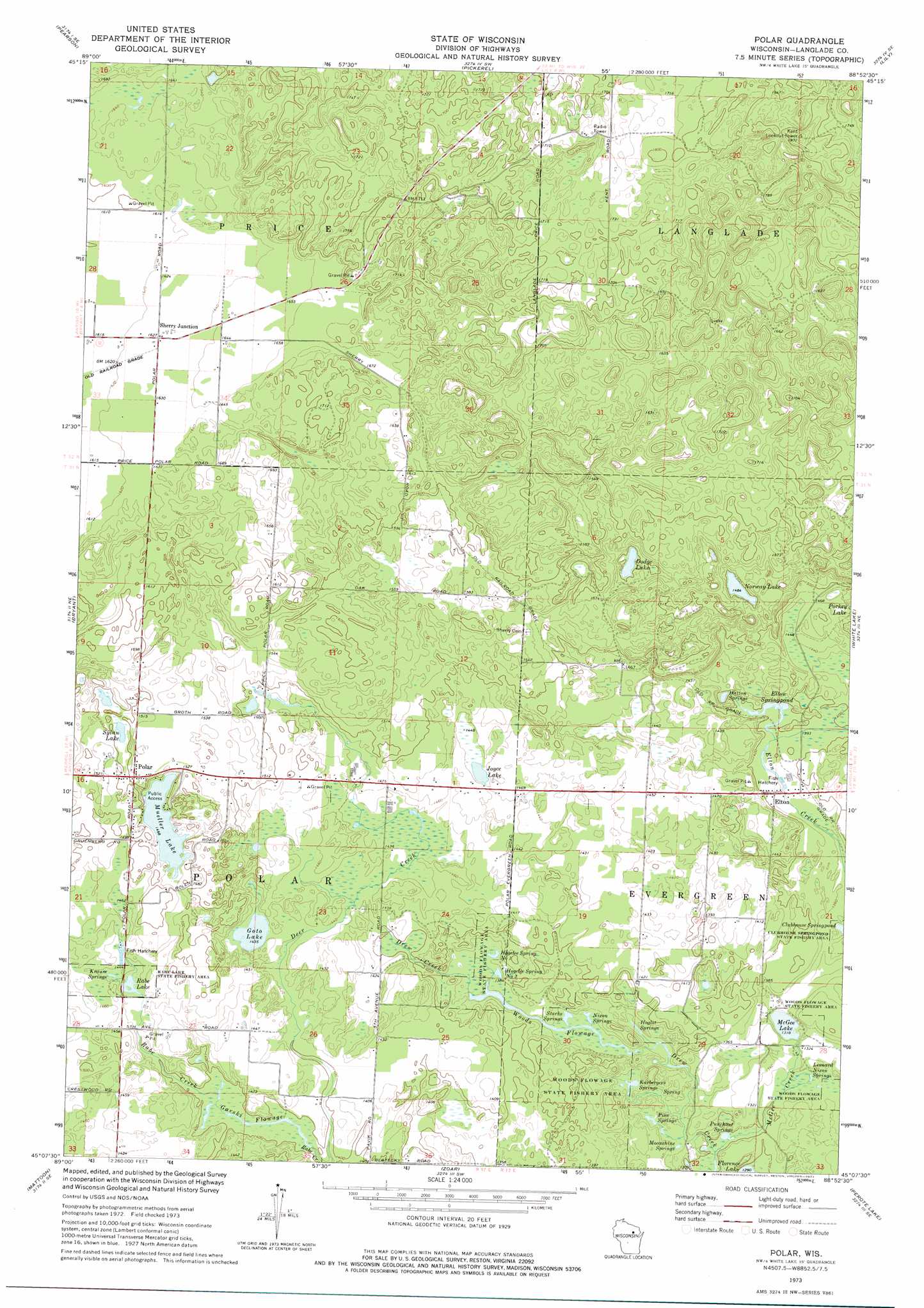
USGS Topo Quad 45088b8 - 1:24,000 scale
| Topo Map Name: | Polar |
| USGS Topo Quad ID: | 45088b8 |
| Print Size: | ca. 21 1/4" wide x 27" high |
| Southeast Coordinates: | 45.125° N latitude / 88.875° W longitude |
| Map Center Coordinates: | 45.1875° N latitude / 88.9375° W longitude |
| U.S. State: | WI |
| Filename: | o45088b8.jpg |
| Download Map JPG Image: | Polar topo map 1:24,000 scale |
| Map Type: | Topographic |
| Topo Series: | 7.5´ |
| Map Scale: | 1:24,000 |
| Source of Map Images: | United States Geological Survey (USGS) |
| Alternate Map Versions: |
Polar WI 1973, updated 1977 Download PDF Buy paper map Polar WI 2010 Download PDF Buy paper map Polar WI 2013 Download PDF Buy paper map Polar WI 2015 Download PDF Buy paper map |
1:24,000 Topo Quads surrounding Polar
Elcho |
Post Lake |
Mole Lake |
Roberts Lake |
Wabeno |
Kempster |
Pearson |
Pickerel |
Lily |
Reservoir Pond |
Antigo |
Bryant |
Polar |
White Lake |
Langlade |
Aniwa |
Mattoon |
Zoar |
Perote Lake |
Markton |
Birnamwood |
Regina |
Burney Lake |
Neopit |
Keshena |
> Back to 45088a1 at 1:100,000 scale
> Back to 45088a1 at 1:250,000 scale
> Back to U.S. Topo Maps home
Polar topo map: Gazetteer
Polar: Channels
Garski Flowage elevation 423m 1387′Polar: Lakes
Clubhouse Springpond elevation 408m 1338′Dodge Lake elevation 455m 1492′
Elton Springpond elevation 425m 1394′
Goto Lake elevation 437m 1433′
Hatton Springs elevation 426m 1397′
Hoglot Springs elevation 407m 1335′
Joyce Lake elevation 443m 1453′
Karbergers Springs elevation 402m 1318′
Krause Springs elevation 438m 1437′
Leonard Nixon Springs elevation 400m 1312′
McGee Lake elevation 402m 1318′
Mueller Lake elevation 447m 1466′
Nixon Springs elevation 406m 1332′
Norway Lake elevation 452m 1482′
Pine Springs elevation 401m 1315′
Rabe Lake elevation 437m 1433′
Sylan Lake elevation 457m 1499′
Woods Flowage elevation 416m 1364′
Polar: Parks
Clubhouse Springpond State Fishery Area elevation 412m 1351′Rabe Lake State Fishery Area elevation 444m 1456′
Woods Flowage State Fishery Area elevation 429m 1407′
Polar: Populated Places
Elton elevation 423m 1387′Polar elevation 462m 1515′
Sherry Junction elevation 496m 1627′
Polar: Springs
Hogelee Spring Number One elevation 413m 1354′Hogelee Spring Number Two elevation 414m 1358′
Moonshine Springs elevation 401m 1315′
Punchout Springs elevation 396m 1299′
Starks Springs elevation 406m 1332′
Polar: Streams
Drew Creek elevation 396m 1299′McGee Creek elevation 396m 1299′
Polar digital topo map on disk
Buy this Polar topo map showing relief, roads, GPS coordinates and other geographical features, as a high-resolution digital map file on DVD: