Mattoon Topo Map Wisconsin
To zoom in, hover over the map of Mattoon
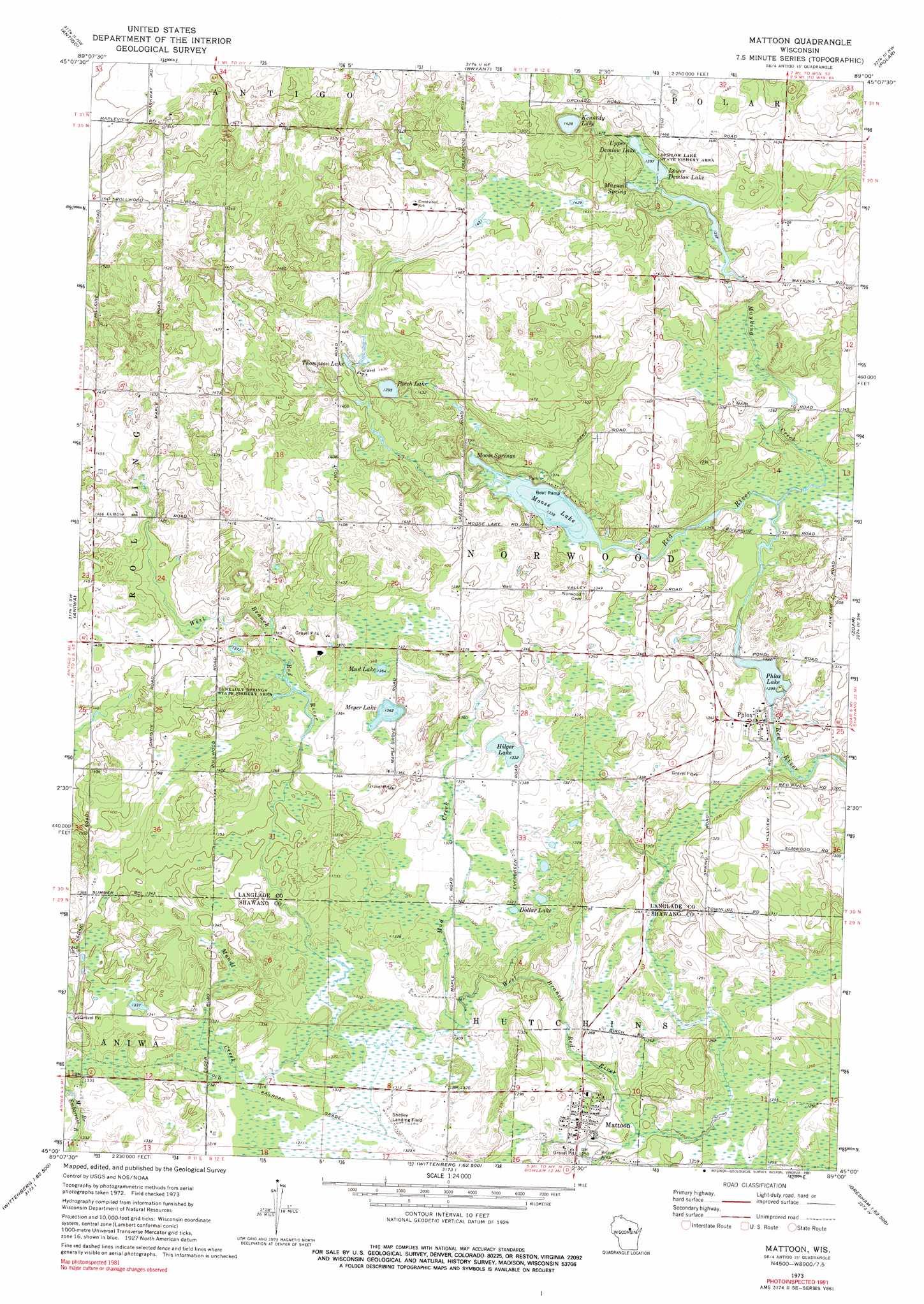
USGS Topo Quad 45089a1 - 1:24,000 scale
| Topo Map Name: | Mattoon |
| USGS Topo Quad ID: | 45089a1 |
| Print Size: | ca. 21 1/4" wide x 27" high |
| Southeast Coordinates: | 45° N latitude / 89° W longitude |
| Map Center Coordinates: | 45.0625° N latitude / 89.0625° W longitude |
| U.S. State: | WI |
| Filename: | o45089a1.jpg |
| Download Map JPG Image: | Mattoon topo map 1:24,000 scale |
| Map Type: | Topographic |
| Topo Series: | 7.5´ |
| Map Scale: | 1:24,000 |
| Source of Map Images: | United States Geological Survey (USGS) |
| Alternate Map Versions: |
Mattoon WI 1973, updated 1976 Download PDF Buy paper map Mattoon WI 1973, updated 1991 Download PDF Buy paper map Mattoon WI 2010 Download PDF Buy paper map Mattoon WI 2013 Download PDF Buy paper map Mattoon WI 2015 Download PDF Buy paper map |
1:24,000 Topo Quads surrounding Mattoon
Bavaria |
Kempster |
Pearson |
Pickerel |
Lily |
Black Brook |
Antigo |
Bryant |
Polar |
White Lake |
Hogarty |
Aniwa |
Mattoon |
Zoar |
Perote Lake |
Hatley |
Birnamwood |
Regina |
Burney Lake |
Neopit |
Mission Lake |
Wittenberg |
Shepley |
Bowler |
Gresham |
> Back to 45089a1 at 1:100,000 scale
> Back to 45088a1 at 1:250,000 scale
> Back to U.S. Topo Maps home
Mattoon topo map: Gazetteer
Mattoon: Airports
Kitty Hawk Estates Airport elevation 432m 1417′Shelley Airport elevation 402m 1318′
Mattoon: Dams
Phlox WP269 Dam elevation 394m 1292′Mattoon: Lakes
Demlow Lake elevation 424m 1391′Dollar Lake elevation 404m 1325′
Hilger Lake elevation 406m 1332′
Kennedy Lake elevation 435m 1427′
Lower Demlow Lake elevation 425m 1394′
Meyer Lake elevation 415m 1361′
Moose Lake elevation 408m 1338′
Mud Lake elevation 413m 1354′
Perch Lake elevation 425m 1394′
Thompson Lake elevation 425m 1394′
Trout Lake (historical) elevation 429m 1407′
Upper Demlow Lake elevation 425m 1394′
Mattoon: Parks
Demlow Lake State Fishery Area elevation 433m 1420′Deneault Springs State Fishery Area elevation 433m 1420′
Mattoon: Populated Places
Mattoon elevation 388m 1272′Phlox elevation 398m 1305′
Mattoon: Reservoirs
Phlox Lake elevation 394m 1292′Phlox Pond 13 elevation 396m 1299′
Mattoon: Springs
Maxwell Spring elevation 425m 1394′Moose Springs elevation 408m 1338′
Mattoon: Streams
Mattoon Creek elevation 379m 1243′Mayking Creek elevation 402m 1318′
Mondl Creek elevation 399m 1309′
Mud Creek elevation 397m 1302′
Mattoon digital topo map on disk
Buy this Mattoon topo map showing relief, roads, GPS coordinates and other geographical features, as a high-resolution digital map file on DVD: