Mole Lake Topo Map Wisconsin
To zoom in, hover over the map of Mole Lake
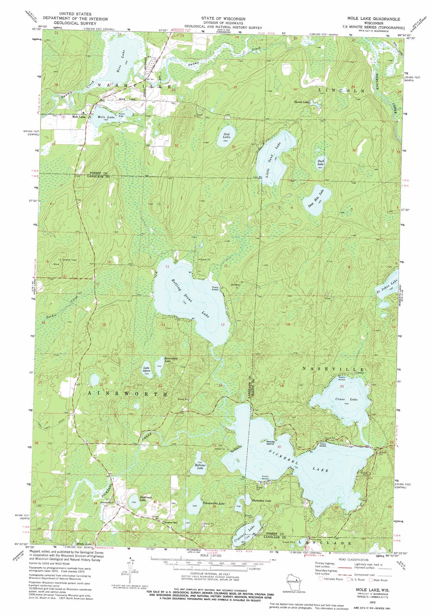
USGS Topo Quad 45088d8 - 1:24,000 scale
| Topo Map Name: | Mole Lake |
| USGS Topo Quad ID: | 45088d8 |
| Print Size: | ca. 21 1/4" wide x 27" high |
| Southeast Coordinates: | 45.375° N latitude / 88.875° W longitude |
| Map Center Coordinates: | 45.4375° N latitude / 88.9375° W longitude |
| U.S. State: | WI |
| Filename: | o45088d8.jpg |
| Download Map JPG Image: | Mole Lake topo map 1:24,000 scale |
| Map Type: | Topographic |
| Topo Series: | 7.5´ |
| Map Scale: | 1:24,000 |
| Source of Map Images: | United States Geological Survey (USGS) |
| Alternate Map Versions: |
Mole Lake WI 1973, updated 1976 Download PDF Buy paper map Mole Lake WI 2010 Download PDF Buy paper map Mole Lake WI 2013 Download PDF Buy paper map Mole Lake WI 2015 Download PDF Buy paper map |
1:24,000 Topo Quads surrounding Mole Lake
Starks |
Monico Ne |
Argonne |
Crandon Ne |
Newald |
Monico |
Nashville |
Crandon |
Lake Lucerne |
Laona |
Elcho |
Post Lake |
Mole Lake |
Roberts Lake |
Wabeno |
Kempster |
Pearson |
Pickerel |
Lily |
Reservoir Pond |
Antigo |
Bryant |
Polar |
White Lake |
Langlade |
> Back to 45088a1 at 1:100,000 scale
> Back to 45088a1 at 1:250,000 scale
> Back to U.S. Topo Maps home
Mole Lake topo map: Gazetteer
Mole Lake: Islands
Woods Island elevation 469m 1538′Mole Lake: Lakes
Berendsen Lake elevation 471m 1545′Crane Lake elevation 468m 1535′
Crystal Lake elevation 468m 1535′
Deadman Lake elevation 467m 1532′
Deep Hole Lake elevation 489m 1604′
Duck Lake elevation 490m 1607′
Hollister Lake elevation 468m 1535′
Horseshoe Lake elevation 469m 1538′
Lake Agnes elevation 471m 1545′
Little Sand Lake elevation 485m 1591′
Mole Lake elevation 473m 1551′
Oak Lake elevation 497m 1630′
Pickerel Lake elevation 468m 1535′
Rice Lake elevation 467m 1532′
Rolling Stone Lake elevation 468m 1535′
Saint Johns Lake elevation 485m 1591′
Skunk Lake elevation 487m 1597′
Tekakwitha Lake elevation 469m 1538′
Mole Lake: Populated Places
Mole Lake elevation 473m 1551′Mole Lake: Streams
Gliske Creek elevation 467m 1532′Outlet Creek elevation 481m 1578′
Mole Lake digital topo map on disk
Buy this Mole Lake topo map showing relief, roads, GPS coordinates and other geographical features, as a high-resolution digital map file on DVD: