Cambridge Topo Map Minnesota
To zoom in, hover over the map of Cambridge
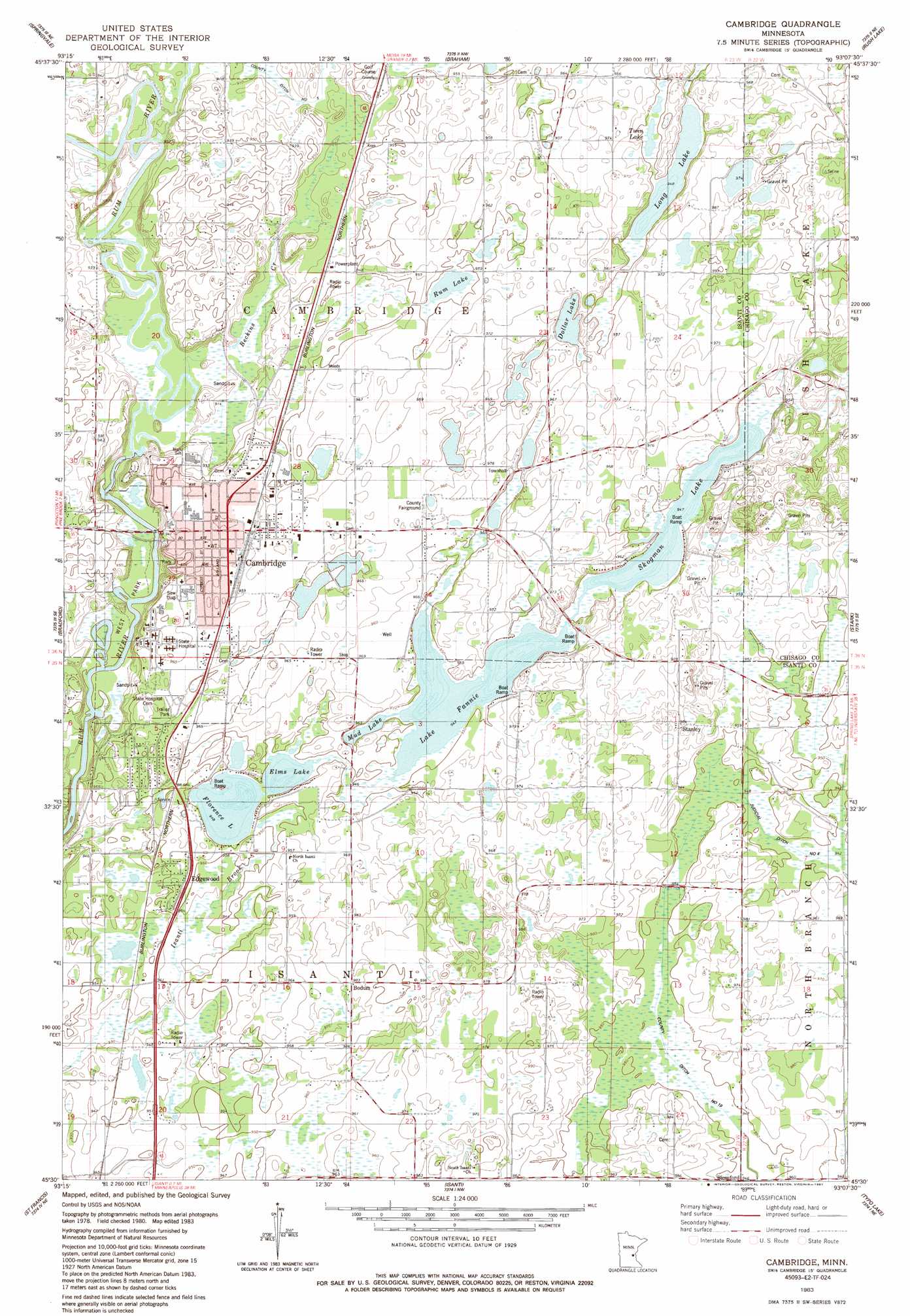
USGS Topo Quad 45093e2 - 1:24,000 scale
| Topo Map Name: | Cambridge |
| USGS Topo Quad ID: | 45093e2 |
| Print Size: | ca. 21 1/4" wide x 27" high |
| Southeast Coordinates: | 45.5° N latitude / 93.125° W longitude |
| Map Center Coordinates: | 45.5625° N latitude / 93.1875° W longitude |
| U.S. State: | MN |
| Filename: | o45093e2.jpg |
| Download Map JPG Image: | Cambridge topo map 1:24,000 scale |
| Map Type: | Topographic |
| Topo Series: | 7.5´ |
| Map Scale: | 1:24,000 |
| Source of Map Images: | United States Geological Survey (USGS) |
| Alternate Map Versions: |
Cambridge MN 1983, updated 1984 Download PDF Buy paper map Cambridge MN 2010 Download PDF Buy paper map Cambridge MN 2013 Download PDF Buy paper map Cambridge MN 2016 Download PDF Buy paper map |
1:24,000 Topo Quads surrounding Cambridge
Ogilvie |
Mora South |
Grasston |
Henriette |
Pine City |
Dalbo |
Springvale |
Braham |
Rush Lake |
Rush City |
Wyanett |
Bradford |
Cambridge |
Stark |
North Branch |
Crown |
Saint Francis |
Isanti |
Typo Lake |
Stacy |
Nowthen |
Cedar |
Coon Lake Beach |
Linwood |
Forest Lake |
> Back to 45093e1 at 1:100,000 scale
> Back to 45092a1 at 1:250,000 scale
> Back to U.S. Topo Maps home
Cambridge topo map: Gazetteer
Cambridge: Canals
County Ditch Number Five elevation 277m 908′County Ditch Number Ninteen elevation 287m 941′
Cambridge: Lakes
Dollar Lake elevation 288m 944′Elms Lake elevation 287m 941′
Florence Lake elevation 287m 941′
Joe's Lake elevation 287m 941′
Lake Fannie elevation 287m 941′
Long Lake elevation 287m 941′
Mud Lake elevation 287m 941′
Rum Lake elevation 287m 941′
Skogman Lake elevation 287m 941′
Twin Lake elevation 287m 941′
Cambridge: Parks
Brown Park elevation 293m 961′Claes Johnson Recreation Area elevation 295m 967′
East Park elevation 286m 938′
Peterson Park elevation 291m 954′
Watertower Park elevation 292m 958′
West Park elevation 275m 902′
Cambridge: Populated Places
Blomford elevation 288m 944′Bodum elevation 300m 984′
Cambridge elevation 293m 961′
Edgewood elevation 293m 961′
Minnesota Boys Town elevation 298m 977′
Pine Village Mobile Home Park elevation 297m 974′
Stanley elevation 299m 980′
Cambridge: Post Offices
Blomford Post Office (historical) elevation 288m 944′Bodum Post Office (historical) elevation 300m 984′
Cambridge Post Office elevation 294m 964′
Stanley Post Office (historical) elevation 299m 980′
Cambridge: Streams
Beckins Creek elevation 276m 905′Cambridge digital topo map on disk
Buy this Cambridge topo map showing relief, roads, GPS coordinates and other geographical features, as a high-resolution digital map file on DVD: