Ludlow Topo Map South Dakota
To zoom in, hover over the map of Ludlow
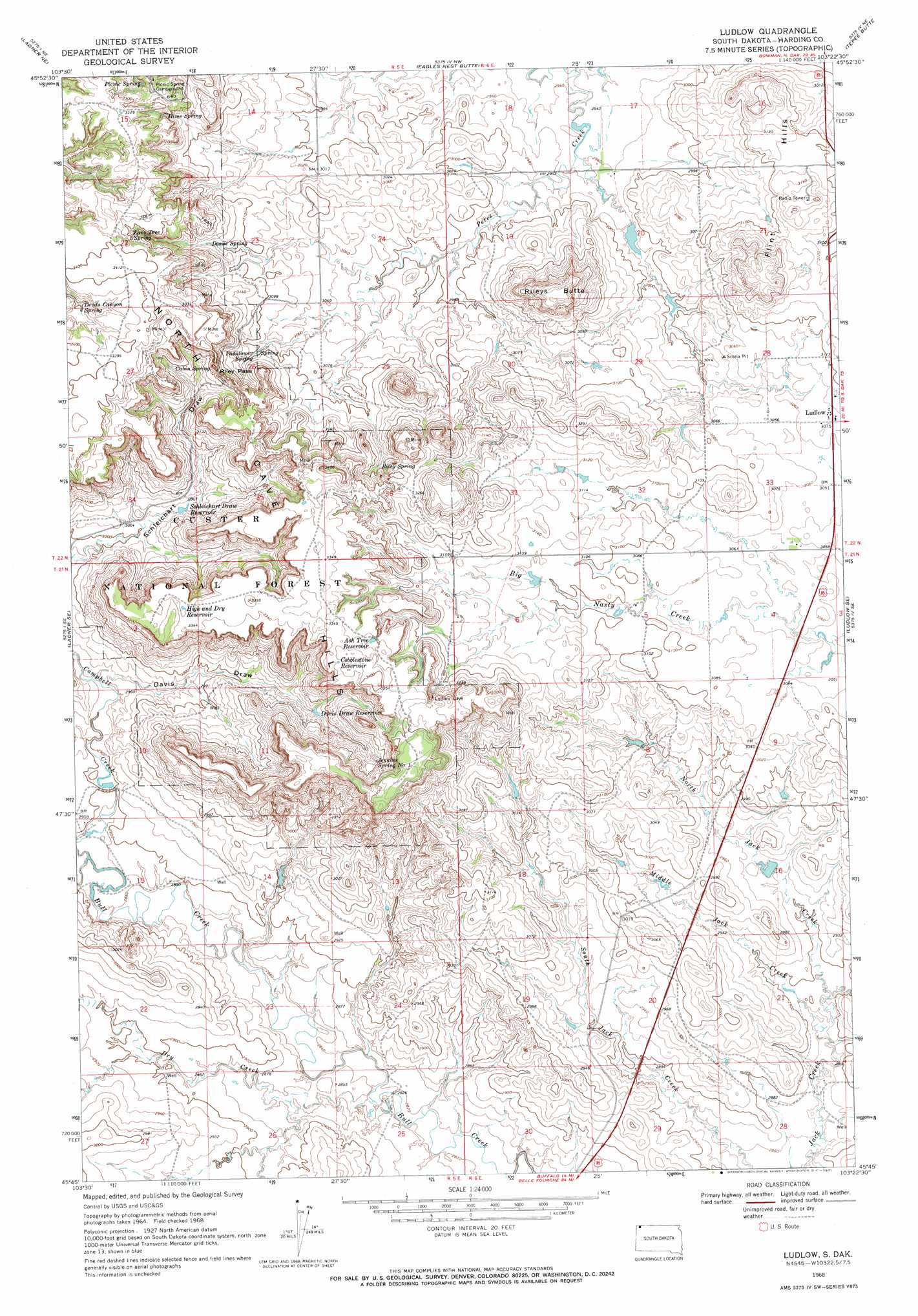
USGS Topo Quad 45103g4 - 1:24,000 scale
| Topo Map Name: | Ludlow |
| USGS Topo Quad ID: | 45103g4 |
| Print Size: | ca. 21 1/4" wide x 27" high |
| Southeast Coordinates: | 45.75° N latitude / 103.375° W longitude |
| Map Center Coordinates: | 45.8125° N latitude / 103.4375° W longitude |
| U.S. State: | SD |
| Filename: | o45103g4.jpg |
| Download Map JPG Image: | Ludlow topo map 1:24,000 scale |
| Map Type: | Topographic |
| Topo Series: | 7.5´ |
| Map Scale: | 1:24,000 |
| Source of Map Images: | United States Geological Survey (USGS) |
| Alternate Map Versions: |
Ludlow SD 1968, updated 1971 Download PDF Buy paper map Ludlow SD 1993, updated 1996 Download PDF Buy paper map Ludlow SD 2005, updated 2007 Download PDF Buy paper map Ludlow SD 2012 Download PDF Buy paper map Ludlow SD 2015 Download PDF Buy paper map |
| FStopo: | US Forest Service topo Ludlow is available: Download FStopo PDF Download FStopo TIF |
1:24,000 Topo Quads surrounding Ludlow
Camel Butte |
Rhame Se |
Bowman Sw |
Bowman Se |
Scranton Sw |
Table Mountain |
Ladner Ne |
Eagles Nest Butte |
Tepee Buttes |
Bowman-Haley Dam |
Ladner |
Ladner Se |
Ludlow |
Ludlow Se |
Ralph Sw |
Lahti Butte |
Mckenzie Butte |
Hay Creek |
Sheep Pen Draw |
Reva Nw |
Saddle Butte |
Buffalo |
Sheep Pen Draw Sw |
Sheep Pen Draw Se |
Battleship Rock |
> Back to 45103e1 at 1:100,000 scale
> Back to 45102a1 at 1:250,000 scale
> Back to U.S. Topo Maps home
Ludlow topo map: Gazetteer
Ludlow: Dams
Jacobi Dam elevation 891m 2923′Tufte Dam elevation 907m 2975′
Ludlow: Gaps
Riley Pass elevation 1008m 3307′Ludlow: Populated Places
Ludlow elevation 937m 3074′Ludlow: Ranges
Flint Hills elevation 945m 3100′North Cave Hills elevation 1017m 3336′
Ludlow: Reservoirs
Ash Tree Reservoir elevation 1019m 3343′Cobblestone Reservoir elevation 1022m 3353′
Davis Draw Reservoir elevation 933m 3061′
High and Dry Reservoir elevation 1017m 3336′
Schleichart Draw Reservoir elevation 922m 3024′
Ludlow: Springs
Cabin Spring elevation 959m 3146′Devils Canyon Spring elevation 1006m 3300′
Doane Spring elevation 951m 3120′
Hime Spring elevation 971m 3185′
Jenkins Spring Number One elevation 974m 3195′
Lone Tree Spring elevation 1008m 3307′
Padalower Spring elevation 946m 3103′
Picnic Spring elevation 975m 3198′
Riley Spring elevation 966m 3169′
Ludlow: Streams
Campbell Creek elevation 872m 2860′Dry Creek elevation 860m 2821′
Middle Jack Creek elevation 873m 2864′
North Jack Creek elevation 875m 2870′
Ludlow: Summits
Rileys Butte elevation 1031m 3382′Ludlow: Valleys
Davis Draw elevation 891m 2923′Ludlow: Wells
K and R Well elevation 971m 3185′Ketchum Well elevation 1005m 3297′
Ludlow digital topo map on disk
Buy this Ludlow topo map showing relief, roads, GPS coordinates and other geographical features, as a high-resolution digital map file on DVD:
Eastern Montana & Western North Dakota
Buy digital topo maps: Eastern Montana & Western North Dakota