Hungry Ridge Topo Map Idaho
To zoom in, hover over the map of Hungry Ridge
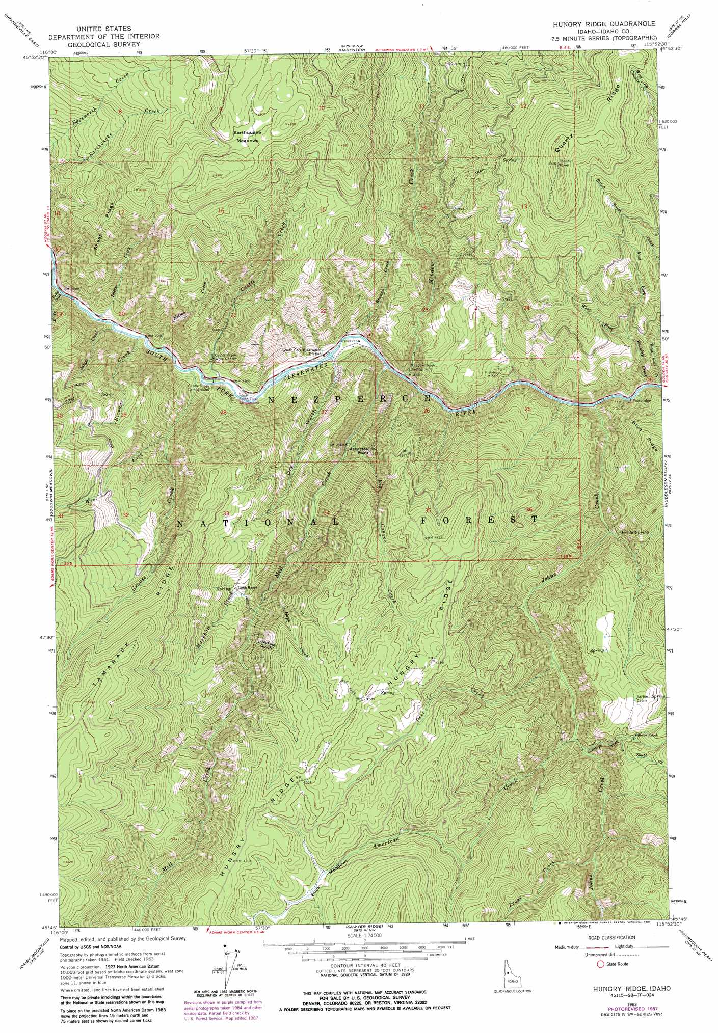
USGS Topo Quad 45115g8 - 1:24,000 scale
| Topo Map Name: | Hungry Ridge |
| USGS Topo Quad ID: | 45115g8 |
| Print Size: | ca. 21 1/4" wide x 27" high |
| Southeast Coordinates: | 45.75° N latitude / 115.875° W longitude |
| Map Center Coordinates: | 45.8125° N latitude / 115.9375° W longitude |
| U.S. State: | ID |
| Filename: | o45115g8.jpg |
| Download Map JPG Image: | Hungry Ridge topo map 1:24,000 scale |
| Map Type: | Topographic |
| Topo Series: | 7.5´ |
| Map Scale: | 1:24,000 |
| Source of Map Images: | United States Geological Survey (USGS) |
| Alternate Map Versions: |
Hungry Ridge ID 1963, updated 1965 Download PDF Buy paper map Hungry Ridge ID 1963, updated 1987 Download PDF Buy paper map Hungry Ridge ID 1995, updated 1999 Download PDF Buy paper map Hungry Ridge ID 2011 Download PDF Buy paper map Hungry Ridge ID 2013 Download PDF Buy paper map |
| FStopo: | US Forest Service topo Hungry Ridge is available: Download FStopo PDF Download FStopo TIF |
1:24,000 Topo Quads surrounding Hungry Ridge
Nezperce Sw |
Nezperce Se |
Stites |
Big Cedar |
Lodge Point |
Grangeville West |
Grangeville East |
Harpster |
Corral Hill |
Pilot Knob |
White Bird Hill |
Goodwin Meadows |
Hungry Ridge |
Huddleson Bluff |
Golden |
Mckinzie Creek |
Dairy Mountain |
Sawyer Ridge |
Sourdough Peak |
North Pole |
John Day Mountain |
Florence |
Hanover Mountain |
Marble Butte |
Buffalo Hump |
> Back to 45115e1 at 1:100,000 scale
> Back to 45114a1 at 1:250,000 scale
> Back to U.S. Topo Maps home
Hungry Ridge topo map: Gazetteer
Hungry Ridge: Flats
Buck Meadows elevation 1334m 4376′Earthquake Meadows elevation 1455m 4773′
Hungry Ridge: Mines
Fisher Mine elevation 785m 2575′Hungry Ridge: Populated Places
Asbestos Point elevation 789m 2588′Hungry Ridge: Ridges
Hungry Ridge elevation 1435m 4708′Quartz Ridge elevation 1515m 4970′
Sheep Ridge elevation 1237m 4058′
Tamarack Ridge elevation 1407m 4616′
Hungry Ridge: Springs
Freds Spring elevation 865m 2837′Hungry Ridge: Streams
American Creek elevation 910m 2985′Big Canyon Creek elevation 780m 2559′
Bivouac Creek elevation 690m 2263′
Browns Creek elevation 700m 2296′
Bully Creek elevation 672m 2204′
Castle Creek elevation 696m 2283′
Deer Creek elevation 883m 2896′
East Fork Wickiup Creek elevation 927m 3041′
Gilmore Creek elevation 920m 3018′
Grouse Creek elevation 687m 2253′
Hays Creek elevation 914m 2998′
Johns Creek elevation 732m 2401′
Jungle Creek elevation 683m 2240′
Markham Creek elevation 926m 3038′
Meadow Creek elevation 712m 2335′
Mill Creek elevation 709m 2326′
Nelson Creek elevation 682m 2237′
Ralph Smith Creek elevation 751m 2463′
Sheep Creek elevation 674m 2211′
South Fork Gilmore Creek elevation 1073m 3520′
Trout Creek elevation 980m 3215′
West Fork Grouse Creek elevation 827m 2713′
West Fork Wickiup Creek elevation 927m 3041′
Wickiup Creek elevation 738m 2421′
Hungry Ridge: Valleys
Dry Gulch elevation 695m 2280′Jackass Gulch elevation 939m 3080′
Hungry Ridge digital topo map on disk
Buy this Hungry Ridge topo map showing relief, roads, GPS coordinates and other geographical features, as a high-resolution digital map file on DVD: