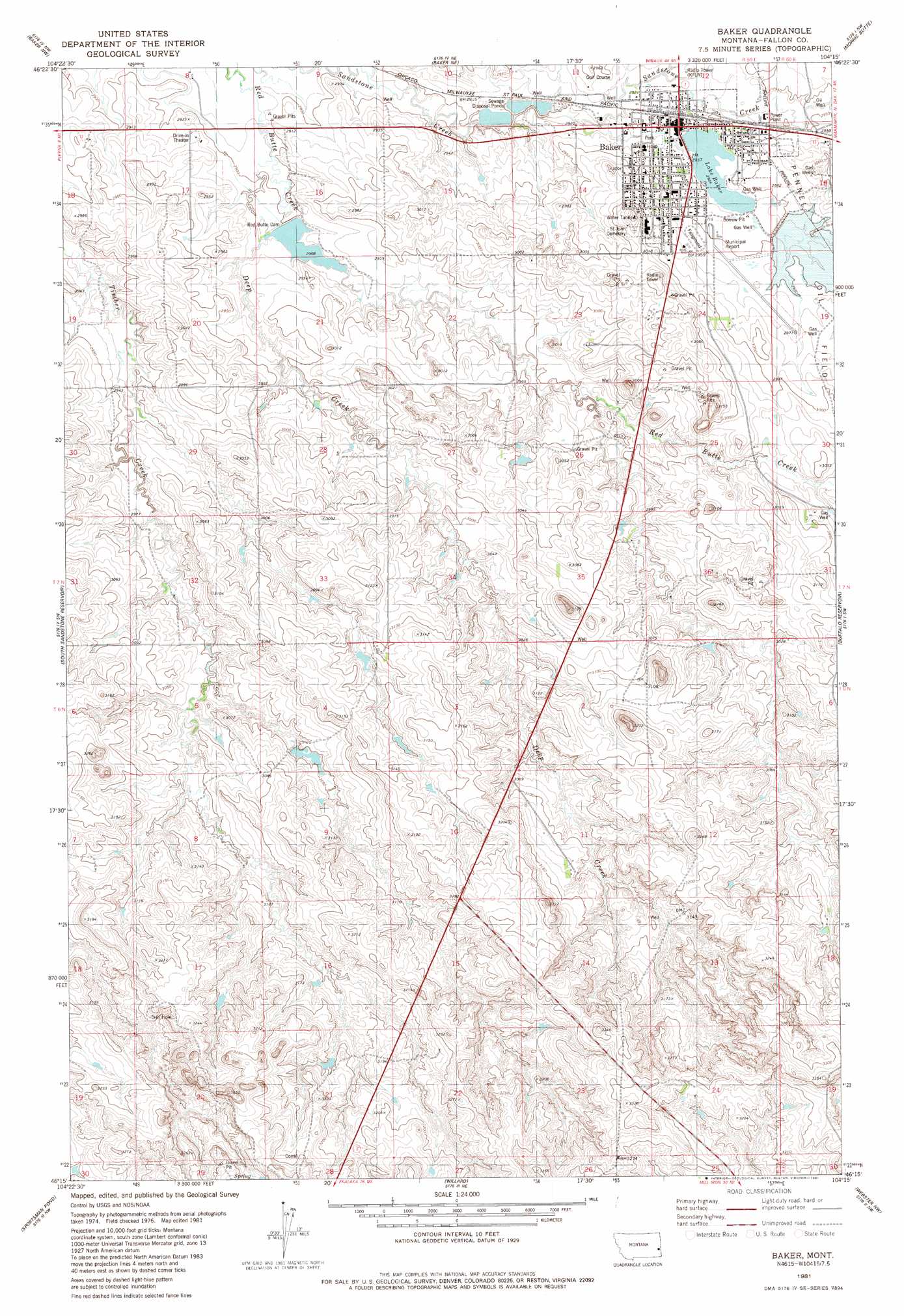
Baker Topo Map Montana
To zoom in, hover over the map of Baker
USGS Topo Quad 46104c3 - 1:24,000 scale
| Topo Map Name: | Baker |
| USGS Topo Quad ID: | 46104c3 |
| Print Size: | ca. 21 1/4" wide x 27" high |
| Southeast Coordinates: | 46.25° N latitude / 104.25° W longitude |
| Map Center Coordinates: | 46.3125° N latitude / 104.3125° W longitude |
| U.S. State: | MT |
| Filename: | o46104c3.jpg |
| Download Map JPG Image: | Baker topo map 1:24,000 scale |
| Map Type: | Topographic |
| Topo Series: | 7.5´ |
| Map Scale: | 1:24,000 |
| Source of Map Images: | United States Geological Survey (USGS) |
| Alternate Map Versions: |
Baker MT 1981, updated 1981 Download PDF Buy paper map Baker MT 2011 Download PDF Buy paper map Baker MT 2014 Download PDF Buy paper map |
1:24,000 Topo Quads surrounding Baker
Lawrence Creek West |
Lawrence Creek East |
Rush Hall Reservoir |
Shell Butte |
Ollie |
Plevna |
Baker Nw |
Baker Ne |
Morris Butte |
Badland Draw |
Little Pine Creek |
South Sandstone Reservoir |
Baker |
Buffalo Reservoir |
Waterhole Creek |
Seven-Up Butte |
Sportsman Pond |
Willard |
Webster Nw |
Webster Ne |
Piney Butte |
Medicine Rocks State Park |
Willard Se |
Webster |
Scole School |
> Back to 46104a1 at 1:100,000 scale
> Back to 46104a1 at 1:250,000 scale
> Back to U.S. Topo Maps home
Baker topo map: Gazetteer
Baker: Airports
Baker Municipal Airport elevation 908m 2979′Baker: Dams
Lower Baker Dam elevation 903m 2962′Red Butte Dam elevation 887m 2910′
Upper Baker Dam elevation 900m 2952′
Baker: Lakes
Lake Baker elevation 899m 2949′Baker: Parks
Baker City Park elevation 898m 2946′Iron Horse Park elevation 904m 2965′
Jaycee Park elevation 903m 2962′
Mangold Field elevation 901m 2956′
Senior Citizens Centennial Park elevation 898m 2946′
Steve McClain Memorial Park elevation 897m 2942′
Triangle Park elevation 902m 2959′
Walts RV Memorial Park elevation 897m 2942′
Baker: Populated Places
Baker elevation 895m 2936′Baker: Post Offices
Baker Post Office elevation 901m 2956′Baker: Reservoirs
Lake Baker elevation 903m 2962′Baker: Streams
Deep Creek elevation 894m 2933′Baker: Wells
06N59E03DD__01 Well elevation 944m 3097′06N59E11BD__01 Well elevation 933m 3061′
06N59E11CAD_01 Well elevation 955m 3133′
06N59E11DB__01 Well elevation 956m 3136′
06N60E18BD__01 Well elevation 956m 3136′
07N54E27AD__01 Well elevation 936m 3070′
07N59E08CA__01 Well elevation 889m 2916′
07N59E08DA__01 Well elevation 884m 2900′
07N59E11CA__01 Well elevation 897m 2942′
07N59E11CCA_01 Well elevation 894m 2933′
07N59E11CDB_01 Well elevation 895m 2936′
07N59E11DCA_01 Well elevation 904m 2965′
07N59E11DCB_01 Well elevation 898m 2946′
07N59E12CA__01 Well elevation 896m 2939′
07N59E14AAC_01 Well elevation 900m 2952′
07N59E14DA__01 Well elevation 928m 3044′
07N59E17BA__01 Well elevation 899m 2949′
07N59E18AA__01 Well elevation 898m 2946′
07N59E18DA__01 Well elevation 913m 2995′
07N59E23BBC_01 Well elevation 925m 3034′
07N59E24BD__01 Well elevation 905m 2969′
07N59E24CB__01 Well elevation 934m 3064′
07N59E24DA__01 Well elevation 921m 3021′
07N59E24DB__01 Well elevation 926m 3038′
07N59E25BA__01 Well elevation 928m 3044′
07N59E25BB__01 Well elevation 920m 3018′
07N59E26AA__01 Well elevation 924m 3031′
07N59E26AB__01 Well elevation 907m 2975′
07N59E27DA__01 Well elevation 929m 3047′
07N59E33CA__01 Well elevation 931m 3054′
07N59E33DB__01 Well elevation 932m 3057′
07N59E34DC__01 Well elevation 939m 3080′
07N59E36CA__01 Well elevation 929m 3047′
07N60E31BA__01 Well elevation 930m 3051′
Baker digital topo map on disk
Buy this Baker topo map showing relief, roads, GPS coordinates and other geographical features, as a high-resolution digital map file on DVD:
Eastern Montana & Western North Dakota
Buy digital topo maps: Eastern Montana & Western North Dakota