Rock Springs School Topo Map Montana
To zoom in, hover over the map of Rock Springs School
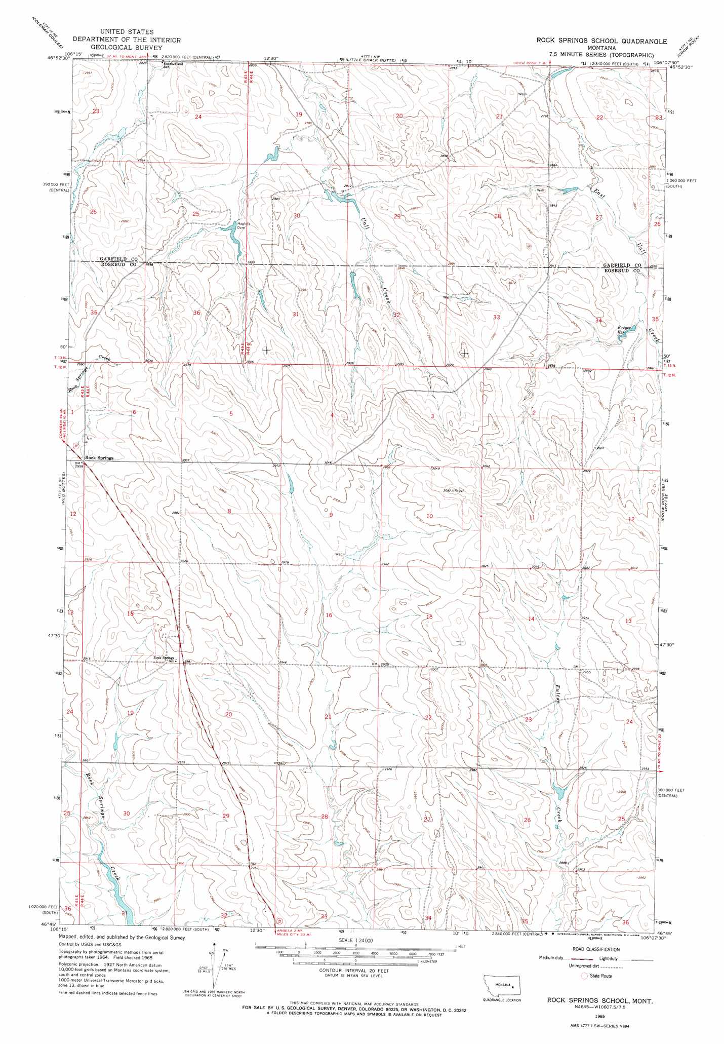
USGS Topo Quad 46106g2 - 1:24,000 scale
| Topo Map Name: | Rock Springs School |
| USGS Topo Quad ID: | 46106g2 |
| Print Size: | ca. 21 1/4" wide x 27" high |
| Southeast Coordinates: | 46.75° N latitude / 106.125° W longitude |
| Map Center Coordinates: | 46.8125° N latitude / 106.1875° W longitude |
| U.S. State: | MT |
| Filename: | o46106g2.jpg |
| Download Map JPG Image: | Rock Springs School topo map 1:24,000 scale |
| Map Type: | Topographic |
| Topo Series: | 7.5´ |
| Map Scale: | 1:24,000 |
| Source of Map Images: | United States Geological Survey (USGS) |
| Alternate Map Versions: |
Rock Springs School MT 1965, updated 1968 Download PDF Buy paper map Rock Springs School MT 2011 Download PDF Buy paper map Rock Springs School MT 2014 Download PDF Buy paper map |
1:24,000 Topo Quads surrounding Rock Springs School
Calamity Coulee |
Sleepy Hollow |
Tree Coulee School |
Hedstrom Lake Se |
Heitz School |
Hillside |
Coleman Coulee |
Little Chalk Butte |
Crow Rock |
Combs Ranch |
Clear Water Reservoir |
Red Buttes |
Rock Springs School |
Crow Rock Se |
Twin Buttes School |
Van Burton Creek |
Alkali Creek |
Angela |
Angela Ne |
Horse Creek Hill |
Wild Horse Pass |
Wild Horse Pass Se |
Hobo Coulee |
N Bar Coulee |
Deadman Creek |
> Back to 46106e1 at 1:100,000 scale
> Back to 46106a1 at 1:250,000 scale
> Back to U.S. Topo Maps home
Rock Springs School topo map: Gazetteer
Rock Springs School: Dams
Alay Number 1 Dam elevation 857m 2811′Alay Number 2 Dam elevation 850m 2788′
Floodly Dam elevation 872m 2860′
Haglof Reservoir Dam elevation 866m 2841′
Haglofs Dam elevation 864m 2834′
Rock Springs Dam elevation 894m 2933′
Rock Springs School: Populated Places
Rock Springs elevation 898m 2946′Rock Springs School: Post Offices
Rock Springs Post Office (historical) elevation 900m 2952′Rock Springs School: Reservoirs
Kreger Reservoir elevation 868m 2847′Rock Springs School: Wells
12N44E01CCAB01 Well elevation 899m 2949′12N44E02DDDD01 Well elevation 915m 3001′
12N44E04ABAB01 Well elevation 896m 2939′
12N44E08BCDC01 Well elevation 916m 3005′
12N44E09DCDB01 Well elevation 897m 2942′
12N44E20ACAD01 Well elevation 891m 2923′
12N44E24ACBB01 Well elevation 908m 2979′
12N44E26DDDB01 Well elevation 881m 2890′
13N44E27CCDB01 Well elevation 888m 2913′
13N44E28AACD01 Well elevation 876m 2874′
13N44E28DDDA01 Well elevation 894m 2933′
13N44E28DDDA02 Well elevation 894m 2933′
13N44E30ADAA01 Well elevation 852m 2795′
13N44E33BCBB01 Well elevation 879m 2883′
Rock Springs School digital topo map on disk
Buy this Rock Springs School topo map showing relief, roads, GPS coordinates and other geographical features, as a high-resolution digital map file on DVD:
Eastern Montana & Western North Dakota
Buy digital topo maps: Eastern Montana & Western North Dakota