Grand Forks Topo Map North Dakota
To zoom in, hover over the map of Grand Forks
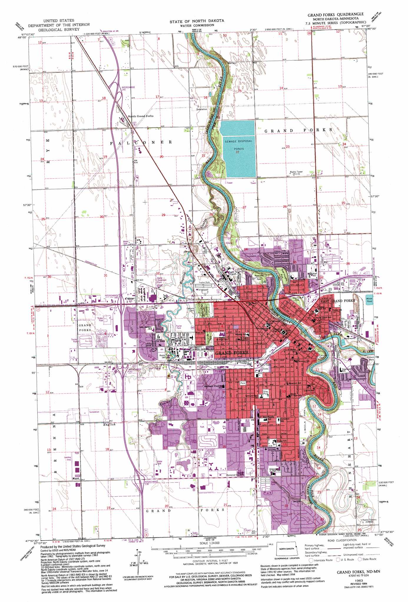
USGS Topo Quad 47097h1 - 1:24,000 scale
| Topo Map Name: | Grand Forks |
| USGS Topo Quad ID: | 47097h1 |
| Print Size: | ca. 21 1/4" wide x 27" high |
| Southeast Coordinates: | 47.875° N latitude / 97° W longitude |
| Map Center Coordinates: | 47.9375° N latitude / 97.0625° W longitude |
| U.S. States: | ND, MN |
| Filename: | O47097H1.jpg |
| Download Map JPG Image: | Grand Forks topo map 1:24,000 scale |
| Map Type: | Topographic |
| Topo Series: | 7.5´ |
| Map Scale: | 1:24,000 |
| Source of Map Images: | United States Geological Survey (USGS) |
| Alternate Map Versions: |
Grand Forks ND 1934, updated 1934 Download PDF Buy paper map Grand Forks ND 1963, updated 1965 Download PDF Buy paper map Grand Forks ND 1963, updated 1980 Download PDF Buy paper map Grand Forks ND 1994, updated 1995 Download PDF Buy paper map Grand Forks ND 2011 Download PDF Buy paper map Grand Forks ND 2014 Download PDF Buy paper map |
1:24,000 Topo Quads surrounding Grand Forks
Ardoch |
Oslo |
Oslo Ne |
Alvarado |
Warren |
Mekinock |
Manvel |
Oslo Se |
Warren Sw |
Tabor |
Emerado |
Kelly |
Grand Forks |
Mallory |
Key West |
Emerado Se |
Grand Forks Sw |
Thompson |
Bygland |
Fisher |
Holmes |
Buxton Nw |
Reynolds |
Climax Nw |
Eldred |
> Back to 47097e1 at 1:100,000 scale
> Back to 47096a1 at 1:250,000 scale
> Back to U.S. Topo Maps home
Grand Forks topo map: Gazetteer
Grand Forks: Airports
J J and T Airport elevation 252m 826′Minnkota Power Field elevation 254m 833′
Grand Forks: Dams
East Grandforks Dam elevation 253m 830′Grand Forks East Dam elevation 246m 807′
Grand Forks Riverside Dam elevation 253m 830′
Riverside Dam elevation 242m 793′
Riverside Dam elevation 242m 793′
Grand Forks: Parks
Central Park elevation 251m 823′Elks Park elevation 255m 836′
Folsom Park elevation 248m 813′
Hylden Field elevation 254m 833′
ITTS Williams Park elevation 254m 833′
Lafave Park elevation 247m 810′
Lincoln Park elevation 254m 833′
Nash Park elevation 253m 830′
O'Leary Park elevation 245m 803′
Red River State Recreation Area elevation 248m 813′
River Heights Park elevation 248m 813′
Riverside Park elevation 249m 816′
Sherlock Park elevation 256m 839′
Stauss Park elevation 254m 833′
University Park elevation 252m 826′
Grand Forks: Populated Places
Calspur elevation 255m 836′East Grand Forks elevation 253m 830′
Grand Forks elevation 253m 830′
North Grand Forks elevation 253m 830′
North Star Mobile Home Park elevation 254m 833′
Grand Forks: Post Offices
East Grand Forks Post Office elevation 253m 830′Grand Forks: Ranges
Altamont Moraine elevation 255m 836′Grand Forks: Reservoirs
Red Lake River elevation 246m 807′Grand Forks: Streams
English Coulee elevation 246m 807′Red Lake River elevation 242m 793′
Grand Forks digital topo map on disk
Buy this Grand Forks topo map showing relief, roads, GPS coordinates and other geographical features, as a high-resolution digital map file on DVD:
Eastern North Dakota & Eastern South Dakota
Buy digital topo maps: Eastern North Dakota & Eastern South Dakota