Spades Mountain Topo Map Idaho
To zoom in, hover over the map of Spades Mountain
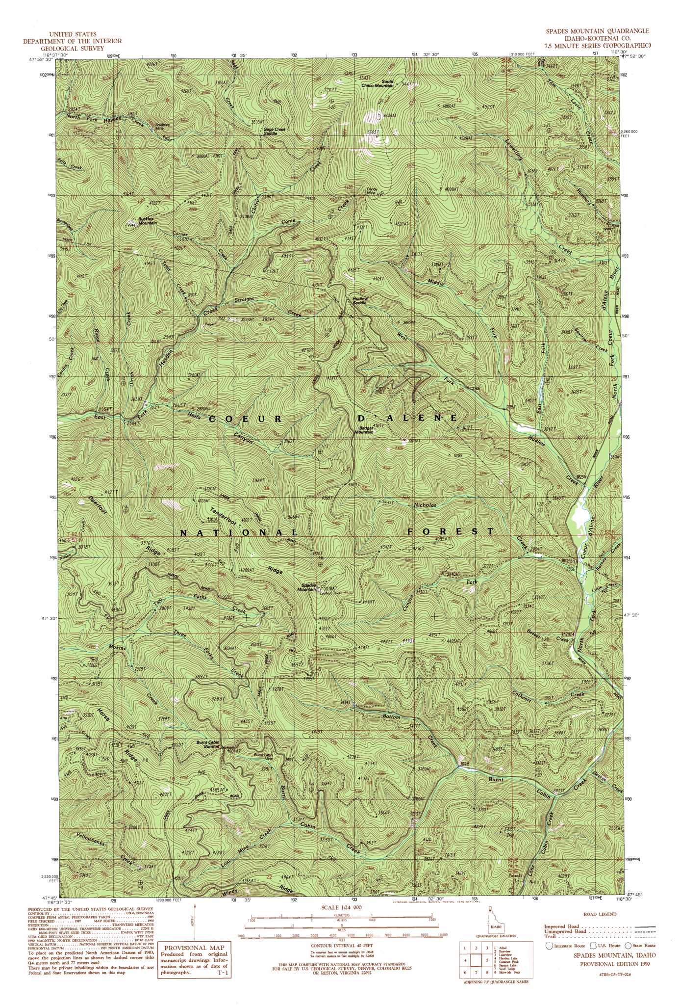
USGS Topo Quad 47116g5 - 1:24,000 scale
| Topo Map Name: | Spades Mountain |
| USGS Topo Quad ID: | 47116g5 |
| Print Size: | ca. 21 1/4" wide x 27" high |
| Southeast Coordinates: | 47.75° N latitude / 116.5° W longitude |
| Map Center Coordinates: | 47.8125° N latitude / 116.5625° W longitude |
| U.S. State: | ID |
| Filename: | o47116g5.jpg |
| Download Map JPG Image: | Spades Mountain topo map 1:24,000 scale |
| Map Type: | Topographic |
| Topo Series: | 7.5´ |
| Map Scale: | 1:24,000 |
| Source of Map Images: | United States Geological Survey (USGS) |
| Alternate Map Versions: |
Spades Mountain ID 1990, updated 1991 Download PDF Buy paper map Spades Mountain ID 1996, updated 1999 Download PDF Buy paper map Spades Mountain ID 2011 Download PDF Buy paper map Spades Mountain ID 2013 Download PDF Buy paper map |
| FStopo: | US Forest Service topo Spades Mountain is available: Download FStopo PDF Download FStopo TIF |
1:24,000 Topo Quads surrounding Spades Mountain
Edgemere |
Careywood |
Cocolalla |
Minerva Peak |
Packsaddle Mountain |
Spirit Lake East |
Athol |
Bayview |
Lakeview |
Faset Peak |
Hayden |
Hayden Lake |
Spades Mountain |
Cataract Peak |
Lamb Peak |
Coeur D'Alene |
Fernan Lake |
Wolf Lodge |
Skitwish Peak |
Bumblebee Peak |
Mica Bay |
Mount Coeur D'Alene |
Lane |
Rose Lake |
Cataldo |
> Back to 47116e1 at 1:100,000 scale
> Back to 47116a1 at 1:250,000 scale
> Back to U.S. Topo Maps home
Spades Mountain topo map: Gazetteer
Spades Mountain: Gaps
Hudlow Saddle elevation 1245m 4084′Sage Creek Saddle elevation 1243m 4078′
Spades Mountain: Mines
Bradbury Mine elevation 1057m 3467′Burnt Cabin Mine elevation 1108m 3635′
Dandy Mine elevation 1426m 4678′
Spades Mountain: Ridges
Deerfoot Ridge elevation 1249m 4097′Tenderfoot Ridge elevation 1355m 4445′
Spades Mountain: Streams
Barney Creek elevation 896m 2939′Beaver Creek elevation 906m 2972′
Bottom Creek elevation 943m 3093′
Canyon Fork elevation 910m 2985′
Cathcart Creek elevation 900m 2952′
Chilco Creek elevation 1043m 3421′
Conie Creek elevation 997m 3270′
Corner Creek elevation 944m 3097′
East Fork Hudlow Creek elevation 920m 3018′
George Creek elevation 925m 3034′
Half Mile Creek elevation 883m 2896′
Hamburg Creek elevation 953m 3126′
Hudlow Creek elevation 898m 2946′
Iron Creek elevation 913m 2995′
Lewelling Creek elevation 952m 3123′
Little Creek elevation 896m 2939′
Lone Cabin Creek elevation 920m 3018′
Lost Mine Creek elevation 1028m 3372′
Middle Fork Hudlow Creek elevation 939m 3080′
Nicholas Creek elevation 895m 2936′
Pyrite Creek elevation 1134m 3720′
Ridge Creek elevation 776m 2545′
Squirrel Creek elevation 928m 3044′
Straight Creek elevation 911m 2988′
Three Forks Creek elevation 855m 2805′
Todd Creek elevation 908m 2979′
Two Forks Creek elevation 870m 2854′
Ulrich Creek elevation 789m 2588′
West Fork Hudlow Creek elevation 937m 3074′
Spades Mountain: Summits
Badger Mountain elevation 1440m 4724′Buckles Mountain elevation 1430m 4691′
Burnt Cabin Summit elevation 1226m 4022′
South Chilco Mountain elevation 1724m 5656′
Spades Mountain elevation 1529m 5016′
Spades Mountain: Valleys
Hells Canyon elevation 813m 2667′Spades Mountain digital topo map on disk
Buy this Spades Mountain topo map showing relief, roads, GPS coordinates and other geographical features, as a high-resolution digital map file on DVD: