Mount Coeur D'Alene Topo Map Idaho
To zoom in, hover over the map of Mount Coeur D'Alene
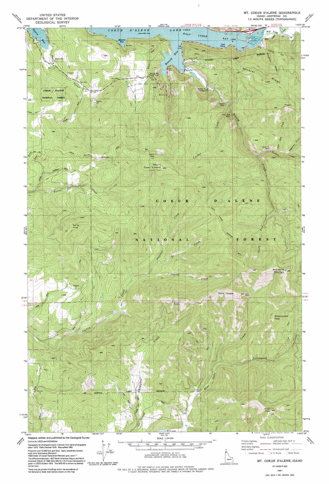
USGS Topo Quad 47116e6 - 1:24,000 scale
| Topo Map Name: | Mount Coeur D'Alene |
| USGS Topo Quad ID: | 47116e6 |
| Print Size: | ca. 21 1/4" wide x 27" high |
| Southeast Coordinates: | 47.5° N latitude / 116.625° W longitude |
| Map Center Coordinates: | 47.5625° N latitude / 116.6875° W longitude |
| U.S. State: | ID |
| Filename: | o47116e6.jpg |
| Download Map JPG Image: | Mount Coeur D'Alene topo map 1:24,000 scale |
| Map Type: | Topographic |
| Topo Series: | 7.5´ |
| Map Scale: | 1:24,000 |
| Source of Map Images: | United States Geological Survey (USGS) |
| Alternate Map Versions: |
Lane SW ID 1975, updated 1977 Download PDF Buy paper map Mt. Coeur D'Alene ID 1981, updated 1982 Download PDF Buy paper map Mount Coeur D'Alene ID 1981, updated 1991 Download PDF Buy paper map Mount Coeur D'Alene ID 1996, updated 1999 Download PDF Buy paper map Mount Coeur D'Alene ID 2011 Download PDF Buy paper map Mount Coeur D'Alene ID 2013 Download PDF Buy paper map |
| FStopo: | US Forest Service topo Mount Coeur D'Alene is available: Download FStopo PDF Download FStopo TIF |
1:24,000 Topo Quads surrounding Mount Coeur D'Alene
Rathdrum |
Hayden |
Hayden Lake |
Spades Mountain |
Cataract Peak |
Post Falls |
Coeur D'Alene |
Fernan Lake |
Wolf Lodge |
Skitwish Peak |
Rockford Bay |
Mica Bay |
Mount Coeur D'Alene |
Lane |
Rose Lake |
Worley |
Harrison |
Black Lake |
Medimont |
Rochat Peak |
Plummer |
Chatcolet |
Benewah Lake |
Saint Maries |
Saint Joe Baldy |
> Back to 47116e1 at 1:100,000 scale
> Back to 47116a1 at 1:250,000 scale
> Back to U.S. Topo Maps home
Mount Coeur D'Alene topo map: Gazetteer
Mount Coeur D'Alene: Bays
Beauty Bay elevation 649m 2129′Moscow Bay elevation 649m 2129′
Neachen Bay elevation 649m 2129′
Wolf Lodge Bay elevation 649m 2129′
Mount Coeur D'Alene: Gaps
Swan Saddle elevation 935m 3067′Mount Coeur D'Alene: Mines
Caribou Mine elevation 710m 2329′Gray Wolf Mine elevation 707m 2319′
Red Horse Mine elevation 879m 2883′
Silver Tip Mine elevation 831m 2726′
Mount Coeur D'Alene: Populated Places
Eddyville elevation 755m 2477′Mount Coeur D'Alene: Ridges
Mineral Ridge elevation 1072m 3517′Mount Coeur D'Alene: Streams
Beauty Creek elevation 649m 2129′Caribou Creek elevation 668m 2191′
Carrill Creek elevation 798m 2618′
Cottonwood Creek elevation 709m 2326′
Lost Man Creek elevation 833m 2732′
North Creek elevation 802m 2631′
Pleasant Creek elevation 770m 2526′
South Fork Beauty Creek elevation 852m 2795′
Steamchet Creek elevation 653m 2142′
Varnum Creek elevation 828m 2716′
Wolf Lodge Creek elevation 656m 2152′
Mount Coeur D'Alene: Summits
Carill Peak elevation 1218m 3996′Cottonwood Peak elevation 1155m 3789′
Mount Coeur d'Alene elevation 1333m 4373′
Red Horse Mountain elevation 1322m 4337′
Swan Peak elevation 1232m 4041′
Turner Peak elevation 1109m 3638′
Mount Coeur D'Alene: Trails
Caribou Ridge National Recreation Trail elevation 1113m 3651′Mount Coeur D'Alene: Valleys
Hageman Draw elevation 872m 2860′Murphys Draw elevation 658m 2158′
Mount Coeur D'Alene digital topo map on disk
Buy this Mount Coeur D'Alene topo map showing relief, roads, GPS coordinates and other geographical features, as a high-resolution digital map file on DVD: