Lakeview Topo Map Idaho
To zoom in, hover over the map of Lakeview
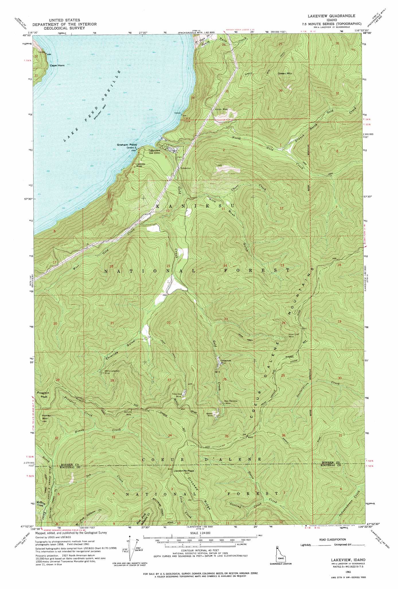
USGS Topo Quad 47116h4 - 1:24,000 scale
| Topo Map Name: | Lakeview |
| USGS Topo Quad ID: | 47116h4 |
| Print Size: | ca. 21 1/4" wide x 27" high |
| Southeast Coordinates: | 47.875° N latitude / 116.375° W longitude |
| Map Center Coordinates: | 47.9375° N latitude / 116.4375° W longitude |
| U.S. State: | ID |
| Filename: | o47116h4.jpg |
| Download Map JPG Image: | Lakeview topo map 1:24,000 scale |
| Map Type: | Topographic |
| Topo Series: | 7.5´ |
| Map Scale: | 1:24,000 |
| Source of Map Images: | United States Geological Survey (USGS) |
| Alternate Map Versions: |
Lakeview ID 1961, updated 1962 Download PDF Buy paper map Lakeview ID 1961, updated 1976 Download PDF Buy paper map Lakeview ID 1996, updated 1999 Download PDF Buy paper map Lakeview ID 2011 Download PDF Buy paper map Lakeview ID 2013 Download PDF Buy paper map |
| FStopo: | US Forest Service topo Lakeview is available: Download FStopo PDF Download FStopo TIF |
1:24,000 Topo Quads surrounding Lakeview
Morton |
Sagle |
Talache |
Hope |
Clark Fork |
Careywood |
Cocolalla |
Minerva Peak |
Packsaddle Mountain |
Derr Point |
Athol |
Bayview |
Lakeview |
Faset Peak |
Cathedral Peak |
Hayden Lake |
Spades Mountain |
Cataract Peak |
Lamb Peak |
Spyglass Peak |
Fernan Lake |
Wolf Lodge |
Skitwish Peak |
Bumblebee Peak |
Steamboat Creek |
> Back to 47116e1 at 1:100,000 scale
> Back to 47116a1 at 1:250,000 scale
> Back to U.S. Topo Maps home
Lakeview topo map: Gazetteer
Lakeview: Capes
Cape Horn elevation 695m 2280′Graham Point elevation 635m 2083′
Lakeview: Gaps
Weber Saddle elevation 1398m 4586′Lakeview: Mines
Bellville Mine elevation 1272m 4173′Conjecture Mine elevation 972m 3188′
Idaho Lakeview Mine elevation 936m 3070′
Keep Cool Mine elevation 1217m 3992′
Lakeview Mines elevation 688m 2257′
New Rainbow Mine elevation 1043m 3421′
Silver Leaf Mine elevation 1236m 4055′
Vulcan Mine elevation 939m 3080′
Weber Mine elevation 1124m 3687′
Lakeview: Populated Places
Lakeview elevation 694m 2276′Lakeview: Streams
Branch North Gold Creek elevation 800m 2624′Cheer Creek elevation 683m 2240′
Gold Creek elevation 630m 2066′
Gosling Creek elevation 1105m 3625′
Honey Creek elevation 1057m 3467′
McHarg Creek elevation 1013m 3323′
North Gold Creek elevation 632m 2073′
North Twin Creek elevation 637m 2089′
Prospect Creek elevation 1091m 3579′
Snowshoe Creek elevation 1042m 3418′
Sob Creek elevation 1033m 3389′
South Twin Creek elevation 639m 2096′
West Gold Creek elevation 729m 2391′
Lakeview: Summits
Green Mountain elevation 1565m 5134′Honey Mountain elevation 1395m 4576′
Jackknife Peak elevation 1599m 5246′
Prospect Peak elevation 1471m 4826′
Lakeview: Trails
Green Mountain Trail elevation 1492m 4895′Lakeview: Valleys
Chloride Gulch elevation 849m 2785′Kick Bush Gulch elevation 764m 2506′
Lakeview digital topo map on disk
Buy this Lakeview topo map showing relief, roads, GPS coordinates and other geographical features, as a high-resolution digital map file on DVD: