Hayden Lake Topo Map Idaho
To zoom in, hover over the map of Hayden Lake
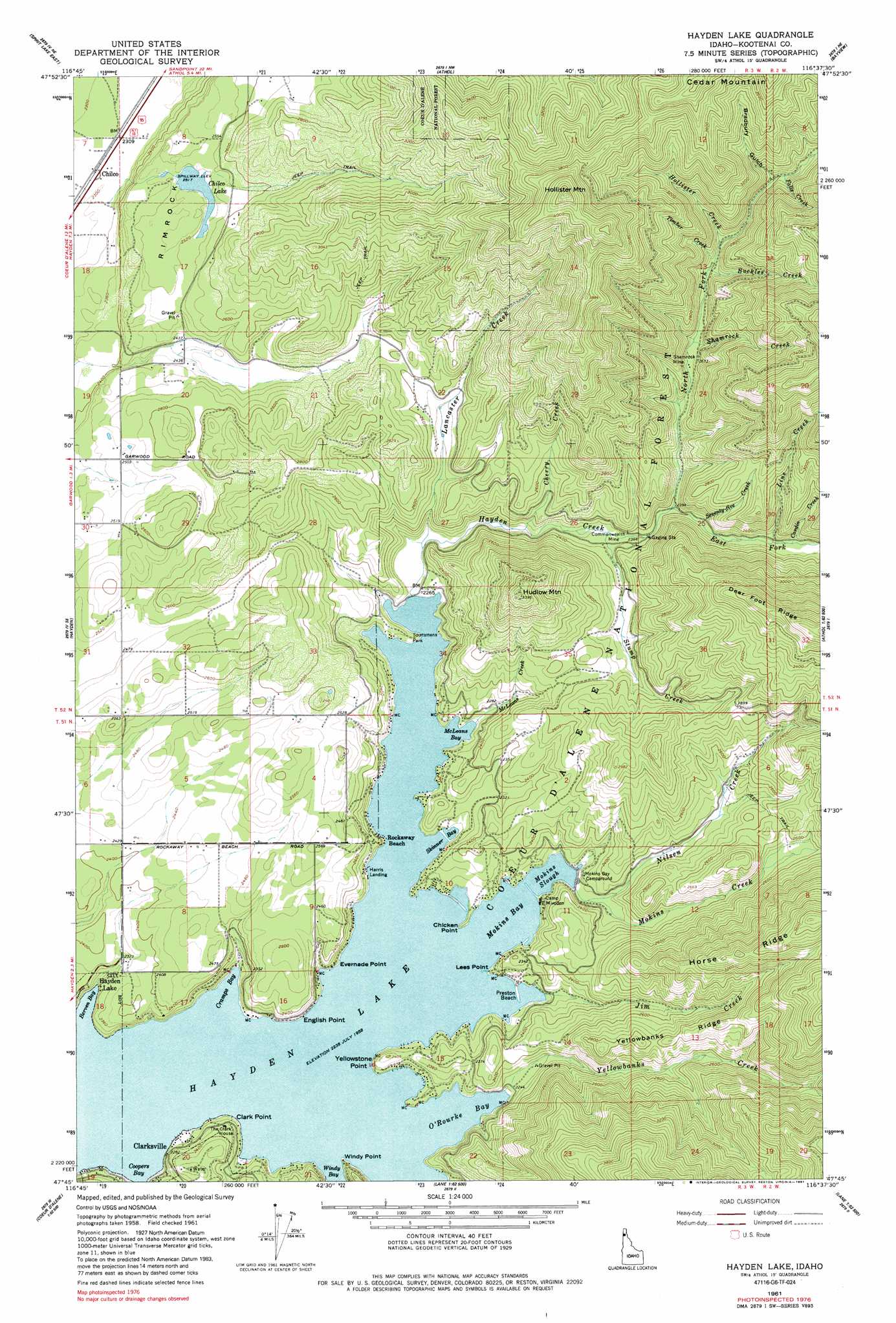
USGS Topo Quad 47116g6 - 1:24,000 scale
| Topo Map Name: | Hayden Lake |
| USGS Topo Quad ID: | 47116g6 |
| Print Size: | ca. 21 1/4" wide x 27" high |
| Southeast Coordinates: | 47.75° N latitude / 116.625° W longitude |
| Map Center Coordinates: | 47.8125° N latitude / 116.6875° W longitude |
| U.S. State: | ID |
| Filename: | o47116g6.jpg |
| Download Map JPG Image: | Hayden Lake topo map 1:24,000 scale |
| Map Type: | Topographic |
| Topo Series: | 7.5´ |
| Map Scale: | 1:24,000 |
| Source of Map Images: | United States Geological Survey (USGS) |
| Alternate Map Versions: |
Hayden Lake ID 1961, updated 1963 Download PDF Buy paper map Hayden Lake ID 1961, updated 1979 Download PDF Buy paper map Hayden Lake ID 1961, updated 1991 Download PDF Buy paper map Hayden Lake ID 1996, updated 1999 Download PDF Buy paper map Hayden Lake ID 2011 Download PDF Buy paper map Hayden Lake ID 2013 Download PDF Buy paper map |
| FStopo: | US Forest Service topo Hayden Lake is available: Download FStopo PDF Download FStopo TIF |
1:24,000 Topo Quads surrounding Hayden Lake
Blanchard |
Edgemere |
Careywood |
Cocolalla |
Minerva Peak |
Spirit Lake West |
Spirit Lake East |
Athol |
Bayview |
Lakeview |
Rathdrum |
Hayden |
Hayden Lake |
Spades Mountain |
Cataract Peak |
Post Falls |
Coeur D'Alene |
Fernan Lake |
Wolf Lodge |
Skitwish Peak |
Rockford Bay |
Mica Bay |
Mount Coeur D'Alene |
Lane |
Rose Lake |
> Back to 47116e1 at 1:100,000 scale
> Back to 47116a1 at 1:250,000 scale
> Back to U.S. Topo Maps home
Hayden Lake topo map: Gazetteer
Hayden Lake: Bays
Berven Bay elevation 683m 2240′Coopers Bay elevation 683m 2240′
Cramps Bay elevation 683m 2240′
McLeans Bay elevation 683m 2240′
Mokins Bay elevation 689m 2260′
O'Rourke Bay elevation 683m 2240′
Skinner Bay elevation 683m 2240′
Hayden Lake: Beaches
Preston Beach elevation 684m 2244′Hayden Lake: Capes
Chicken Point elevation 684m 2244′Clark Point elevation 697m 2286′
English Point elevation 718m 2355′
Evernade Point elevation 703m 2306′
Lees Point elevation 689m 2260′
Windy Point elevation 686m 2250′
Yellowstone Point elevation 718m 2355′
Hayden Lake: Dams
Chilco Dam elevation 768m 2519′Hayden Lake: Guts
Mokins Slough elevation 683m 2240′Hayden Lake: Lakes
Lake Hayden elevation 683m 2240′Hayden Lake: Mines
Commonwealth Mine elevation 720m 2362′Shamrock Mine elevation 762m 2500′
Hayden Lake: Parks
Hayden Lake Sportsman Park elevation 696m 2283′Hayden Lake: Populated Places
Chilco elevation 705m 2312′Clarksville elevation 711m 2332′
English Point elevation 777m 2549′
Harris Landing elevation 698m 2290′
Rockaway Beach elevation 699m 2293′
Hayden Lake: Reservoirs
Chilco Lake elevation 768m 2519′Hayden Lake: Ridges
Yellowbanks Ridge elevation 856m 2808′Hayden Lake: Streams
Buckles Creek elevation 791m 2595′Cardin Creek elevation 761m 2496′
Cherry Creek elevation 695m 2280′
East Fork Hayden Creek elevation 726m 2381′
Falls Creek elevation 860m 2821′
Hayden Creek elevation 684m 2244′
Hollister Creek elevation 815m 2673′
Jim Creek elevation 684m 2244′
Lancaster Creek elevation 686m 2250′
Line Creek elevation 753m 2470′
McLeans Creek elevation 683m 2240′
Mokins Creek elevation 684m 2244′
Nilsen Creek elevation 690m 2263′
North Fork Hayden Creek elevation 726m 2381′
Seventy-Five Creek elevation 737m 2417′
Shamrock Creek elevation 774m 2539′
Stump Creek elevation 712m 2335′
Timber Creek elevation 796m 2611′
Yellowbanks Creek elevation 683m 2240′
Hayden Lake: Summits
Hollister Mountain elevation 1318m 4324′Hudlow Mountain elevation 1019m 3343′
Rimrock elevation 776m 2545′
Hayden Lake: Trails
English Point National Recreation Trail elevation 765m 2509′Hayden Lake: Valleys
Bradbury Gulch elevation 880m 2887′Hayden Lake digital topo map on disk
Buy this Hayden Lake topo map showing relief, roads, GPS coordinates and other geographical features, as a high-resolution digital map file on DVD: