Bayview Topo Map Idaho
To zoom in, hover over the map of Bayview
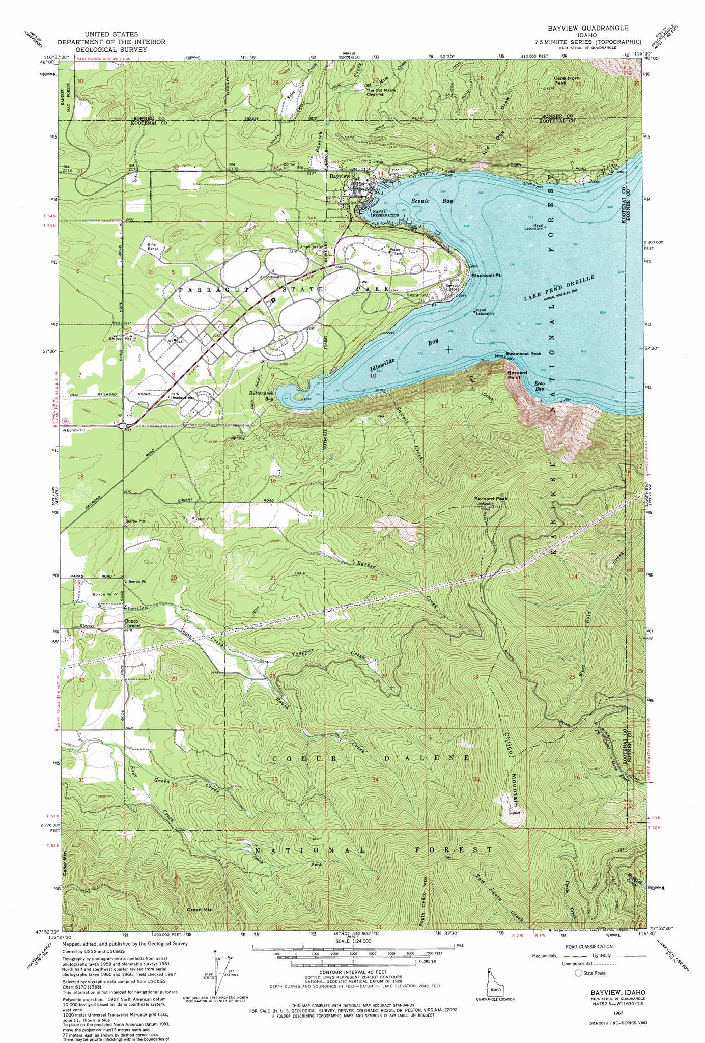
USGS Topo Quad 47116h5 - 1:24,000 scale
| Topo Map Name: | Bayview |
| USGS Topo Quad ID: | 47116h5 |
| Print Size: | ca. 21 1/4" wide x 27" high |
| Southeast Coordinates: | 47.875° N latitude / 116.5° W longitude |
| Map Center Coordinates: | 47.9375° N latitude / 116.5625° W longitude |
| U.S. State: | ID |
| Filename: | o47116h5.jpg |
| Download Map JPG Image: | Bayview topo map 1:24,000 scale |
| Map Type: | Topographic |
| Topo Series: | 7.5´ |
| Map Scale: | 1:24,000 |
| Source of Map Images: | United States Geological Survey (USGS) |
| Alternate Map Versions: |
Bayview ID 1961, updated 1962 Download PDF Buy paper map Bayview ID 1967, updated 1967 Download PDF Buy paper map Bayview ID 1967, updated 1982 Download PDF Buy paper map Bayview ID 1967, updated 1982 Download PDF Buy paper map Bayview ID 1996, updated 1999 Download PDF Buy paper map Bayview ID 2011 Download PDF Buy paper map Bayview ID 2013 Download PDF Buy paper map |
| FStopo: | US Forest Service topo Bayview is available: Download FStopo PDF Download FStopo TIF |
1:24,000 Topo Quads surrounding Bayview
Laclede |
Morton |
Sagle |
Talache |
Hope |
Edgemere |
Careywood |
Cocolalla |
Minerva Peak |
Packsaddle Mountain |
Spirit Lake East |
Athol |
Bayview |
Lakeview |
Faset Peak |
Hayden |
Hayden Lake |
Spades Mountain |
Cataract Peak |
Lamb Peak |
Coeur D'Alene |
Fernan Lake |
Wolf Lodge |
Skitwish Peak |
Bumblebee Peak |
> Back to 47116e1 at 1:100,000 scale
> Back to 47116a1 at 1:250,000 scale
> Back to U.S. Topo Maps home
Bayview topo map: Gazetteer
Bayview: Bays
Echo Bay elevation 630m 2066′Idlewilde Bay elevation 630m 2066′
Scenic Bay elevation 630m 2066′
Bayview: Capes
Blackwell Point elevation 648m 2125′Steamboat Rock elevation 650m 2132′
Bayview: Cliffs
Bernard Point elevation 929m 3047′Bayview: Flats
The Old Maids Clearing elevation 809m 2654′Bayview: Gaps
Cedar Saddle elevation 1137m 3730′Bayview: Parks
Farragut State Park elevation 701m 2299′Bayview: Populated Places
Bayview elevation 639m 2096′Bayview: Streams
Barker Creek elevation 890m 2919′Bayview Creek elevation 679m 2227′
Cat Creek elevation 632m 2073′
Green Creek elevation 800m 2624′
North Fork Sage Creek elevation 904m 2965′
Old Maid Creek elevation 800m 2624′
Roush Creek elevation 813m 2667′
Salee Creek elevation 725m 2378′
Sawpit Creek elevation 631m 2070′
Trapper Creek elevation 813m 2667′
Bayview: Summits
Bernard Peak elevation 1566m 5137′Cape Horn Peak elevation 1371m 4498′
Chilco Mountain elevation 1710m 5610′
Green Mountain elevation 1237m 4058′
Bayview: Trails
Leiberg-Athol Trail elevation 814m 2670′Bayview: Valleys
Old Doe Draw elevation 750m 2460′Bayview digital topo map on disk
Buy this Bayview topo map showing relief, roads, GPS coordinates and other geographical features, as a high-resolution digital map file on DVD: