Iron Lake Topo Map Minnesota
To zoom in, hover over the map of Iron Lake
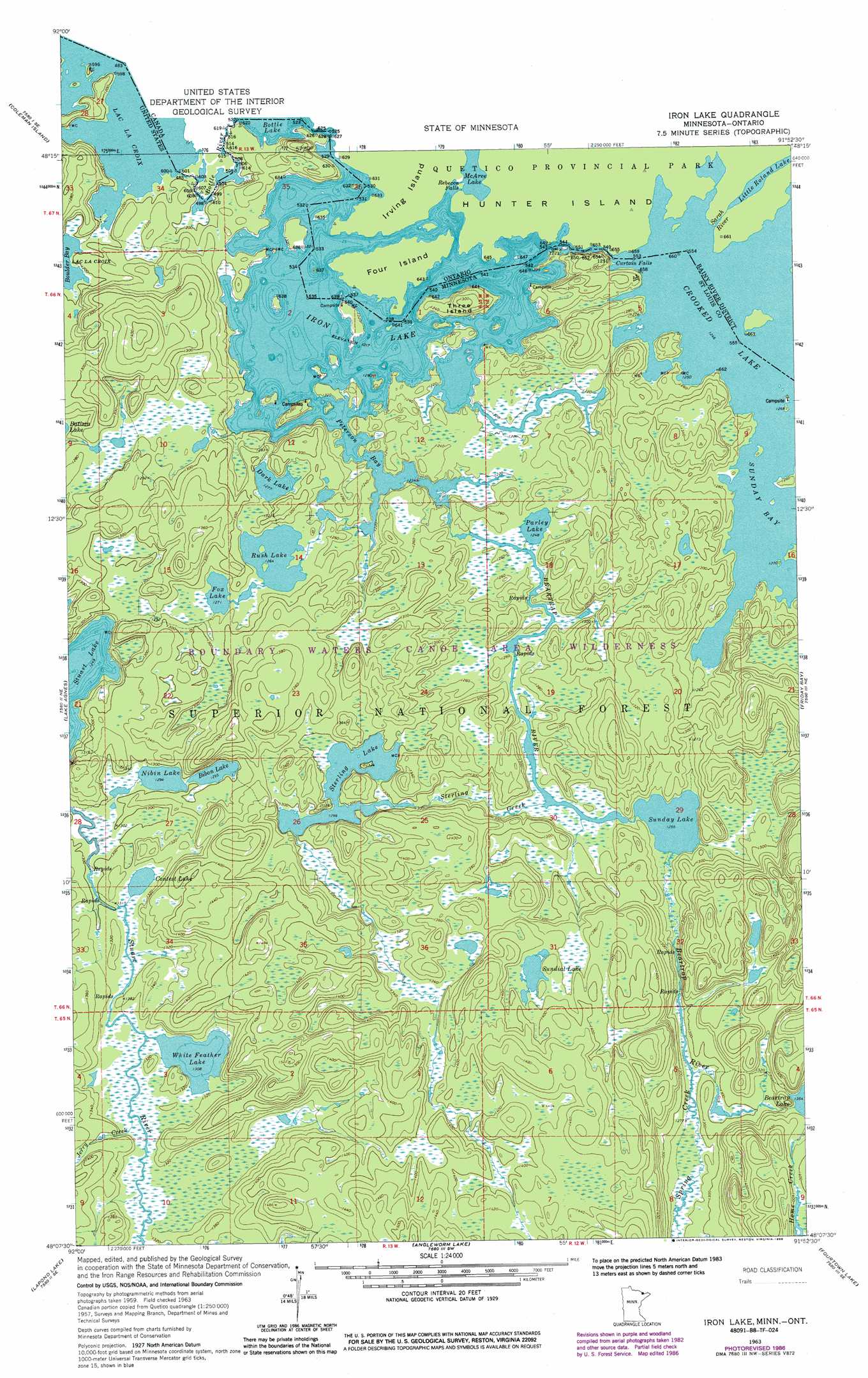
USGS Topo Quad 48091b8 - 1:24,000 scale
| Topo Map Name: | Iron Lake |
| USGS Topo Quad ID: | 48091b8 |
| Print Size: | ca. 21 1/4" wide x 27" high |
| Southeast Coordinates: | 48.125° N latitude / 91.875° W longitude |
| Map Center Coordinates: | 48.1875° N latitude / 91.9375° W longitude |
| U.S. State: | MN |
| Filename: | o48091b8.jpg |
| Download Map JPG Image: | Iron Lake topo map 1:24,000 scale |
| Map Type: | Topographic |
| Topo Series: | 7.5´ |
| Map Scale: | 1:24,000 |
| Source of Map Images: | United States Geological Survey (USGS) |
| Alternate Map Versions: |
Iron Lake MN 1963, updated 1965 Download PDF Buy paper map Iron Lake MN 1963, updated 1986 Download PDF Buy paper map Iron Lake MN 2011 Download PDF Buy paper map Iron Lake MN 2013 Download PDF Buy paper map Iron Lake MN 2016 Download PDF Buy paper map |
| FStopo: | US Forest Service topo Iron Lake is available: Download FStopo PDF Download FStopo TIF |
1:24,000 Topo Quads surrounding Iron Lake
Takucmich Lake |
Coleman Island |
|||
Shell Lake |
Lake Agnes |
Iron Lake |
Friday Bay |
Jackfish Lake |
Bootleg Lake |
Lapond Lake |
Angleworm Lake |
Fourtown Lake |
Basswood Lake West |
Chad Lake |
Crab Lake |
Shagawa Lake |
Ely |
Farm Lake |
> Back to 48091a1 at 1:100,000 scale
> Back to 48090a1 at 1:250,000 scale
> Back to U.S. Topo Maps home
Iron Lake topo map: Gazetteer
Iron Lake: Bays
Peterson Bay elevation 371m 1217′Iron Lake: Falls
Curtain Falls elevation 384m 1259′Iron Lake: Islands
Three Island elevation 398m 1305′Iron Lake: Lakes
Bibon Lake elevation 395m 1295′Contest Lake elevation 399m 1309′
Crooked Lake elevation 387m 1269′
Dark Lake elevation 390m 1279′
Fox Lake elevation 388m 1272′
Iron Lake elevation 371m 1217′
Nibin Lake elevation 395m 1295′
Parley Lake elevation 381m 1250′
Rush Lake elevation 386m 1266′
Sterling Lake elevation 395m 1295′
Sunday Lake elevation 383m 1256′
Sundial Lake elevation 418m 1371′
White Feather Lake elevation 399m 1309′
Iron Lake: Streams
Beartrap River elevation 371m 1217′Bottle River elevation 364m 1194′
Jerry Creek elevation 402m 1318′
Spring Creek elevation 389m 1276′
Sterling Creek elevation 384m 1259′
Iron Lake digital topo map on disk
Buy this Iron Lake topo map showing relief, roads, GPS coordinates and other geographical features, as a high-resolution digital map file on DVD: