Crab Lake Topo Map Minnesota
To zoom in, hover over the map of Crab Lake
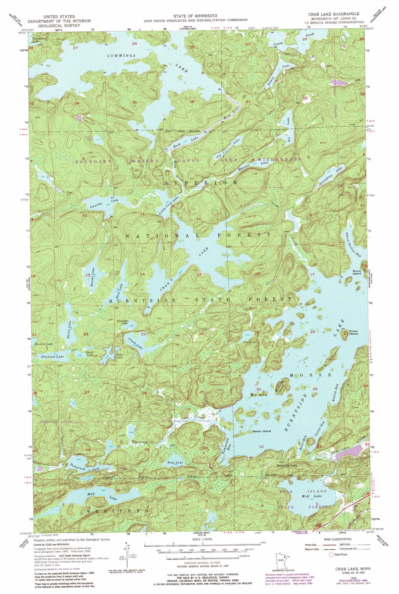
USGS Topo Quad 47092h1 - 1:24,000 scale
| Topo Map Name: | Crab Lake |
| USGS Topo Quad ID: | 47092h1 |
| Print Size: | ca. 21 1/4" wide x 27" high |
| Southeast Coordinates: | 47.875° N latitude / 92° W longitude |
| Map Center Coordinates: | 47.9375° N latitude / 92.0625° W longitude |
| U.S. State: | MN |
| Filename: | o47092h1.jpg |
| Download Map JPG Image: | Crab Lake topo map 1:24,000 scale |
| Map Type: | Topographic |
| Topo Series: | 7.5´ |
| Map Scale: | 1:24,000 |
| Source of Map Images: | United States Geological Survey (USGS) |
| Alternate Map Versions: |
Crab Lake MN 1956, updated 1958 Download PDF Buy paper map Crab Lake MN 1956, updated 1961 Download PDF Buy paper map Crab Lake MN 1956, updated 1986 Download PDF Buy paper map Crab Lake MN 2011 Download PDF Buy paper map Crab Lake MN 2013 Download PDF Buy paper map Crab Lake MN 2016 Download PDF Buy paper map |
| FStopo: | US Forest Service topo Crab Lake is available: Download FStopo PDF Download FStopo TIF |
1:24,000 Topo Quads surrounding Crab Lake
Lake Jeanette |
Shell Lake |
Lake Agnes |
Iron Lake |
Friday Bay |
Astrid Lake |
Bootleg Lake |
Lapond Lake |
Angleworm Lake |
Fourtown Lake |
Sioux Pine Island |
Chad Lake |
Crab Lake |
Shagawa Lake |
Ely |
Tower |
Soudan |
Eagles Nest |
Bear Island |
Kangas Bay |
Biwabik Ne |
Embarrass |
Isaac Lake |
Babbitt |
Babbitt Ne |
> Back to 47092e1 at 1:100,000 scale
> Back to 47092a1 at 1:250,000 scale
> Back to U.S. Topo Maps home
Crab Lake topo map: Gazetteer
Crab Lake: Bays
Hoist Bay elevation 418m 1371′Kaleva Bay elevation 418m 1371′
Outlet Bay elevation 418m 1371′
School Section Bay elevation 418m 1371′
Tamarack Bay elevation 418m 1371′
Crab Lake: Forests
Burntside State Forest elevation 460m 1509′Crab Lake: Islands
Beach Island elevation 419m 1374′Burnt Island elevation 446m 1463′
Dollar Island elevation 439m 1440′
Long Island elevation 425m 1394′
Pine Island elevation 422m 1384′
Snellman Island elevation 436m 1430′
Crab Lake: Lakes
Barefoot Lake elevation 455m 1492′Battle Lake elevation 462m 1515′
Clark Lake elevation 450m 1476′
Coo Lake elevation 428m 1404′
Coxey Pond elevation 454m 1489′
Crab Lake elevation 446m 1463′
Cummings Lake elevation 444m 1456′
Foss Lake elevation 419m 1374′
Geraldine Lake elevation 436m 1430′
Glimmer Lake elevation 460m 1509′
Hassel Lake elevation 461m 1512′
Jig Lake elevation 456m 1496′
Korb Lake elevation 446m 1463′
Little Crab Lake elevation 447m 1466′
Lunetta Lake elevation 447m 1466′
Maxine Lake elevation 447m 1466′
Meat Lake elevation 459m 1505′
Mud Lake elevation 415m 1361′
Ole Lake elevation 450m 1476′
Phantom Lake elevation 462m 1515′
Princess Lake elevation 462m 1515′
Saca Lake elevation 459m 1505′
Silaca Lake elevation 448m 1469′
Sprite Lake elevation 462m 1515′
Tamarack Lake elevation 437m 1433′
Tidbit Lake elevation 453m 1486′
Wolf Lake elevation 426m 1397′
Crab Lake: Populated Places
Burntside Lake elevation 433m 1420′Crab Lake: Post Offices
Nea Post Office (historical) elevation 500m 1640′Crab Lake: Streams
Crab Creek elevation 418m 1371′Korb River elevation 445m 1459′
Tamarack Creek elevation 419m 1374′
Crab Lake digital topo map on disk
Buy this Crab Lake topo map showing relief, roads, GPS coordinates and other geographical features, as a high-resolution digital map file on DVD: