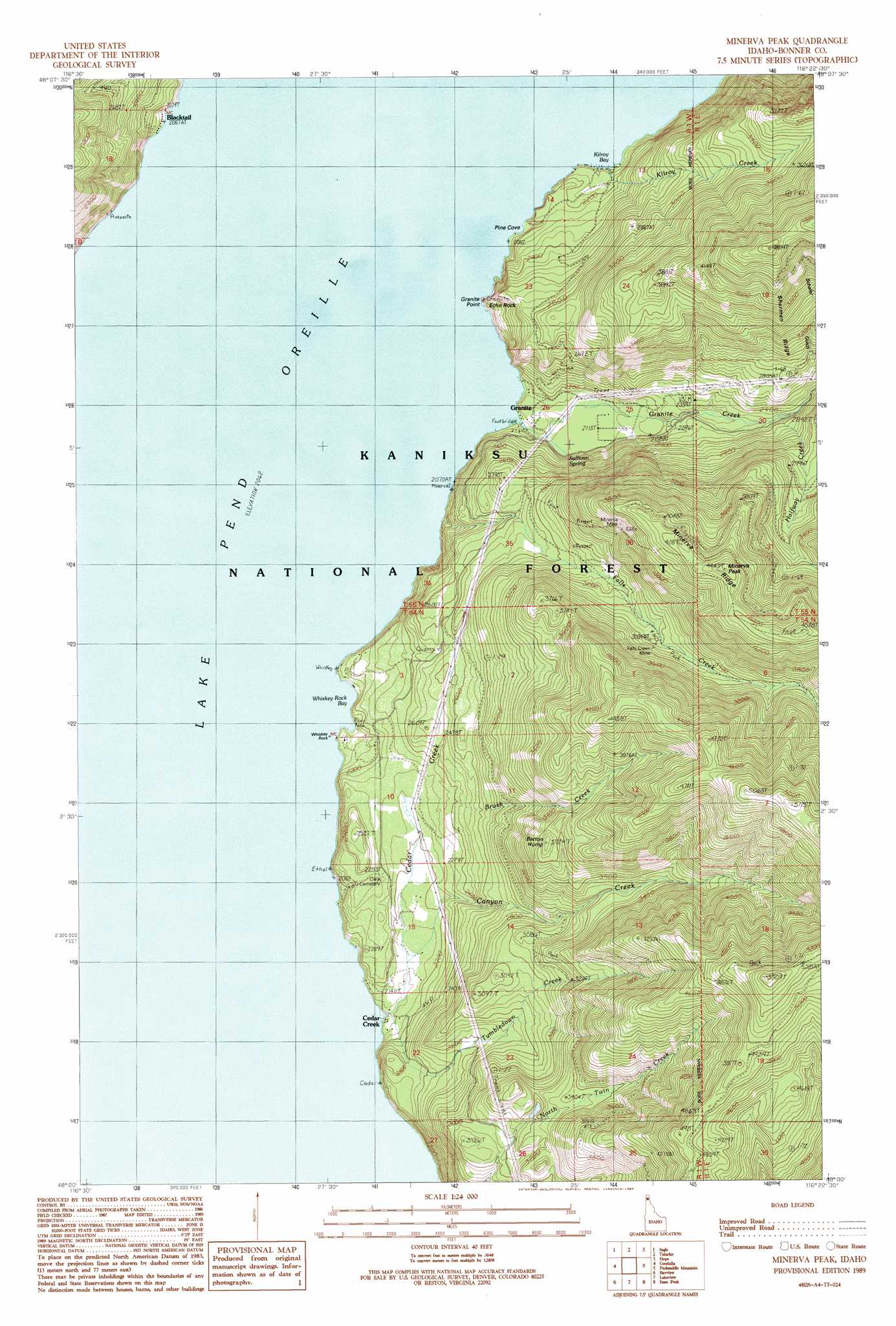
Minerva Peak Topo Map Idaho
To zoom in, hover over the map of Minerva Peak
USGS Topo Quad 48116a4 - 1:24,000 scale
| Topo Map Name: | Minerva Peak |
| USGS Topo Quad ID: | 48116a4 |
| Print Size: | ca. 21 1/4" wide x 27" high |
| Southeast Coordinates: | 48° N latitude / 116.375° W longitude |
| Map Center Coordinates: | 48.0625° N latitude / 116.4375° W longitude |
| U.S. State: | ID |
| Filename: | o48116a4.jpg |
| Download Map JPG Image: | Minerva Peak topo map 1:24,000 scale |
| Map Type: | Topographic |
| Topo Series: | 7.5´ |
| Map Scale: | 1:24,000 |
| Source of Map Images: | United States Geological Survey (USGS) |
| Alternate Map Versions: |
Minerva Peak ID 1989, updated 1989 Download PDF Buy paper map Minerva Peak ID 1996, updated 1999 Download PDF Buy paper map Minerva Peak ID 2011 Download PDF Buy paper map Minerva Peak ID 2013 Download PDF Buy paper map |
| FStopo: | US Forest Service topo Minerva Peak is available: Download FStopo PDF Download FStopo TIF |
1:24,000 Topo Quads surrounding Minerva Peak
Happy Fork Gap |
Sandpoint |
Oden Bay |
Trout Peak |
Trestle Peak |
Morton |
Sagle |
Talache |
Hope |
Clark Fork |
Careywood |
Cocolalla |
Minerva Peak |
Packsaddle Mountain |
Derr Point |
Athol |
Bayview |
Lakeview |
Faset Peak |
Cathedral Peak |
Hayden Lake |
Spades Mountain |
Cataract Peak |
Lamb Peak |
Spyglass Peak |
> Back to 48116a1 at 1:100,000 scale
> Back to 48116a1 at 1:250,000 scale
> Back to U.S. Topo Maps home
Minerva Peak topo map: Gazetteer
Minerva Peak: Bays
Kilroy Bay elevation 630m 2066′Pine Cove elevation 630m 2066′
Whiskey Rock Bay elevation 630m 2066′
Minerva Peak: Capes
Granite Point elevation 664m 2178′Minerva Peak: Cliffs
Echo Rock elevation 786m 2578′Minerva Peak: Mines
Falls Creek Mine elevation 999m 3277′Grey Brothers Lime Quarry elevation 774m 2539′
Minerva Mine elevation 1047m 3435′
Schafer Mine elevation 1453m 4767′
Minerva Peak: Pillars
Whiskey Rock elevation 630m 2066′Minerva Peak: Populated Places
Blacktail elevation 640m 2099′Cedar Creek elevation 661m 2168′
Granite elevation 661m 2168′
Minerva Peak: Ridges
Minerva Ridge elevation 1333m 4373′Sherman Ridge elevation 1199m 3933′
Minerva Peak: Springs
Sullivan Spring elevation 645m 2116′Minerva Peak: Streams
Brush Creek elevation 694m 2276′Canyon Creek elevation 651m 2135′
Cedar Creek elevation 630m 2066′
Falls Creek elevation 630m 2066′
Granite Creek elevation 630m 2066′
Gray Creek elevation 741m 2431′
Halfway Creek elevation 707m 2319′
Kilroy Creek elevation 630m 2066′
Tumbledown Creek elevation 630m 2066′
Minerva Peak: Summits
Barton Hump elevation 1135m 3723′Minerva Peak elevation 1353m 4438′
Minerva Peak digital topo map on disk
Buy this Minerva Peak topo map showing relief, roads, GPS coordinates and other geographical features, as a high-resolution digital map file on DVD: