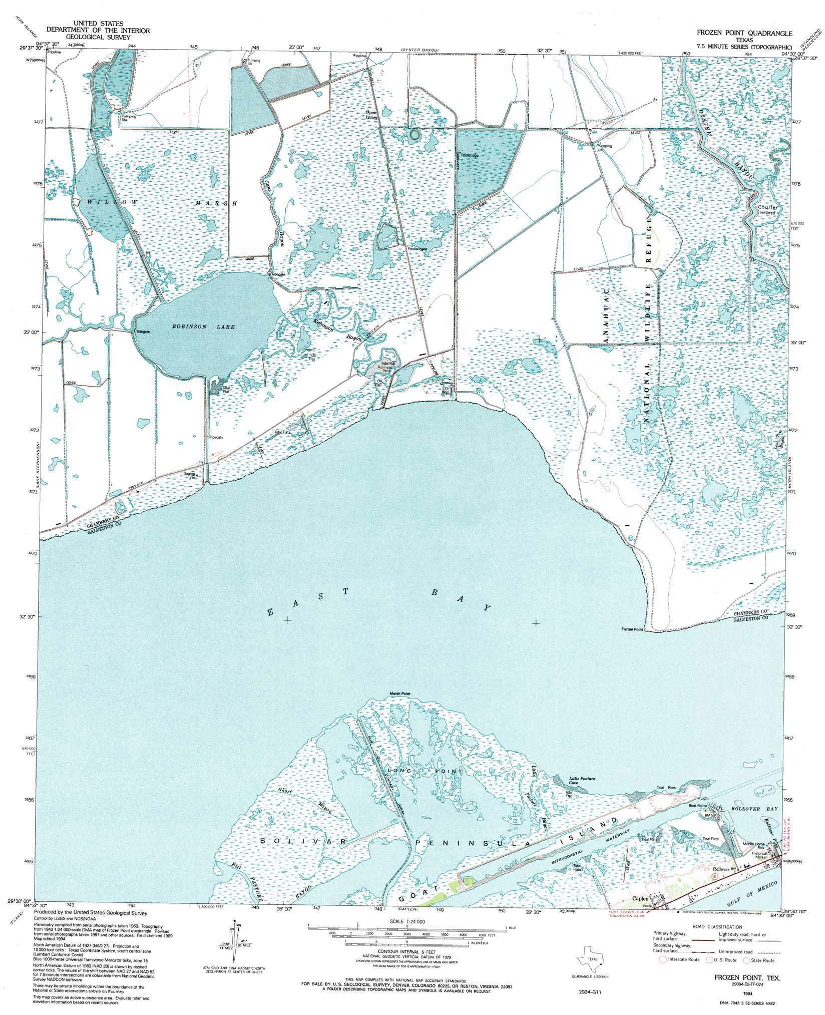
Frozen Point Topo Map Texas
To zoom in, hover over the map of Frozen Point
USGS Topo Quad 29094e5 - 1:24,000 scale
| Topo Map Name: | Frozen Point |
| USGS Topo Quad ID: | 29094e5 |
| Print Size: | ca. 21 1/4" wide x 27" high |
| Southeast Coordinates: | 29.5° N latitude / 94.5° W longitude |
| Map Center Coordinates: | 29.5625° N latitude / 94.5625° W longitude |
| U.S. State: | TX |
| Filename: | o29094e5.jpg |
| Download Map JPG Image: | Frozen Point topo map 1:24,000 scale |
| Map Type: | Topographic |
| Topo Series: | 7.5´ |
| Map Scale: | 1:24,000 |
| Source of Map Images: | United States Geological Survey (USGS) |
| Alternate Map Versions: |
Frozen Point TX 1931 Download PDF Buy paper map Frozen Point TX 1943, updated 1952 Download PDF Buy paper map Frozen Point TX 1962, updated 1964 Download PDF Buy paper map Frozen Point TX 1994, updated 1994 Download PDF Buy paper map Frozen Point TX 2010 Download PDF Buy paper map Frozen Point TX 2013 Download PDF Buy paper map Frozen Point TX 2016 Download PDF Buy paper map |
1:24,000 Topo Quads surrounding Frozen Point
Cove |
Anahuac |
Monroe City |
Stowell |
Hamshire |
Umbrella Point |
Oak Island |
Oyster Bayou |
Stanolind Reservoir |
Whites Ranch |
Smith Point |
Lake Stephenson |
Frozen Point |
High Island |
Mud Lake |
Port Bolivar |
Flake |
Caplen |
||
Galveston |
The Jetties |
> Back to 29094e1 at 1:100,000 scale
> Back to 29094a1 at 1:250,000 scale
> Back to U.S. Topo Maps home
Frozen Point topo map: Gazetteer
Frozen Point: Bays
Little Pasture Cove elevation 0m 0′Frozen Point: Canals
Sun Oil Company Canal elevation 1m 3′Sun Oil Company Canal elevation 0m 0′
Frozen Point: Capes
Frozen Point elevation 0m 0′Long Point elevation 1m 3′
Marsh Point elevation 0m 0′
Frozen Point: Channels
Rollover Pass elevation 0m 0′Frozen Point: Guts
Cane Bayou elevation 2m 6′Ghost Bayou elevation 2m 6′
Little Pasture Bayou elevation 0m 0′
Frozen Point: Islands
Coulter Island elevation 2m 6′Frozen Point: Lakes
Open Lakes elevation 2m 6′Robinson Lake elevation 0m 0′
Frozen Point: Oilfields
East Robinson Lake Gas Field elevation 2m 6′Frozen Point: Parks
Anahuac National Wildlife Refuge elevation 2m 6′Frozen Point: Populated Places
Rollover elevation 2m 6′Frozen Point: Streams
Robinson Bayou elevation 1m 3′Frozen Point: Swamps
Willow Marsh elevation 2m 6′Frozen Point: Trails
Anahuac National Wildlife Refuge Trail elevation 2m 6′Frozen Point digital topo map on disk
Buy this Frozen Point topo map showing relief, roads, GPS coordinates and other geographical features, as a high-resolution digital map file on DVD: