Biloxi Topo Map Mississippi
To zoom in, hover over the map of Biloxi
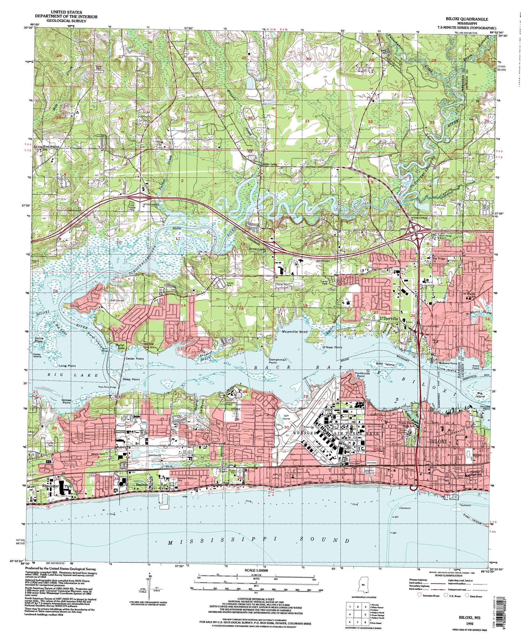
USGS Topo Quad 30088d8 - 1:24,000 scale
| Topo Map Name: | Biloxi |
| USGS Topo Quad ID: | 30088d8 |
| Print Size: | ca. 21 1/4" wide x 27" high |
| Southeast Coordinates: | 30.375° N latitude / 88.875° W longitude |
| Map Center Coordinates: | 30.4375° N latitude / 88.9375° W longitude |
| U.S. State: | MS |
| Filename: | o30088d8.jpg |
| Download Map JPG Image: | Biloxi topo map 1:24,000 scale |
| Map Type: | Topographic |
| Topo Series: | 7.5´ |
| Map Scale: | 1:24,000 |
| Source of Map Images: | United States Geological Survey (USGS) |
| Alternate Map Versions: |
Biloxi MS 1954, updated 1958 Download PDF Buy paper map Biloxi MS 1954, updated 1965 Download PDF Buy paper map Biloxi MS 1954, updated 1966 Download PDF Buy paper map Biloxi MS 1954, updated 1971 Download PDF Buy paper map Biloxi MS 1954, updated 1978 Download PDF Buy paper map Biloxi MS 1992, updated 1998 Download PDF Buy paper map Biloxi MS 2012 Download PDF Buy paper map Biloxi MS 2015 Download PDF Buy paper map |
1:24,000 Topo Quads surrounding Biloxi
Mchenry |
Airey |
Beatrice |
Vestry |
Easen Hill |
Wortham |
Success |
White Plains |
Latimer |
Vancleave |
Gulfport Nw |
Gulfport North |
Biloxi |
Ocean Springs |
Gautier North |
Pass Christian |
Gulfport South |
Deer Island |
Gautier South |
|
Isle Au Pitre |
Cat Island |
Ship Island |
Dog Keys Pass |
Horn Island West |
> Back to 30088a1 at 1:100,000 scale
> Back to 30088a1 at 1:250,000 scale
> Back to U.S. Topo Maps home
Biloxi topo map: Gazetteer
Biloxi: Airports
Gulf Coast Community Hospital-Emergency Helipad elevation 6m 19′Kennedy Executive Airport elevation 13m 42′
Kennedy Field elevation 3m 9′
Lundys Airport elevation 6m 19′
Biloxi: Bays
Back Bay of Biloxi elevation 0m 0′Magnolia Bend elevation 0m 0′
Biloxi: Bends
Devils Elbow elevation 0m 0′Biloxi: Bridges
Burnt Bridge elevation 0m 0′Pops Ferry Bridge elevation 0m 0′
Biloxi: Capes
Avery Point elevation 2m 6′Cedar Point elevation 0m 0′
Damphman Point elevation 3m 9′
Deep Point elevation 0m 0′
Goose Point elevation 0m 0′
Long Point elevation 0m 0′
O'Neal Point elevation 1m 3′
Parkhurst Point elevation 3m 9′
Rhodes Point elevation 1m 3′
Shipyard Point elevation 2m 6′
Biloxi: Crossings
Interchange 41 elevation 5m 16′Interchange 44 elevation 10m 32′
Interchange 46 elevation 7m 22′
Pops Ferry (historical) elevation 0m 0′
Biloxi: Dams
Golf Course Lake Dam elevation 6m 19′Biloxi: Harbors
Biloxi Small Craft Harbor elevation 1m 3′Biloxi: Islands
Big Island elevation 0m 0′Coley Island elevation 1m 3′
Goat Island elevation 0m 0′
Little Island elevation 0m 0′
Marsh Island elevation 0m 0′
Biloxi: Lakes
Big Lake elevation 0m 0′Little Big Lake elevation 0m 0′
Mullet Lake elevation 1m 3′
Biloxi: Parks
Back Bay Park elevation 4m 13′Biloxi Municipal Stadium elevation 4m 13′
Cavalier Field elevation 8m 26′
Circle Park elevation 5m 16′
Hiller Park Recreation Area elevation 5m 16′
John Henry Beck Park elevation 4m 13′
Kings Daughters Memorial elevation 3m 9′
Lee Street Field elevation 4m 13′
Miramar Park elevation 3m 9′
Pops Ferry Park elevation 8m 26′
Saint Marys Playground elevation 7m 22′
Savarro Park elevation 7m 22′
Tanglewood Playground elevation 6m 19′
Voluntee Park elevation 8m 26′
Biloxi: Populated Places
Beauvoir elevation 4m 13′Biloxi elevation 6m 19′
Cedar Lake elevation 3m 9′
De Buys elevation 8m 26′
D'Iberville elevation 4m 13′
Edgewater Park elevation 7m 22′
Heartease (historical) elevation 7m 22′
North Biloxi elevation 8m 26′
Wool Market elevation 10m 32′
Biloxi: Post Offices
Biloxi Post Office elevation 6m 19′Biloxi: Streams
Auguste Bayou elevation 2m 6′Bayou Costapia elevation 2m 6′
Bayou Laporte elevation 1m 3′
Biglin Bayou elevation 0m 0′
Biloxi River elevation 0m 0′
Brasher Bayou elevation 0m 0′
Cypress Creek elevation 2m 6′
Howard Creek elevation 0m 0′
Keegan Bayou elevation 1m 3′
Parker Creek elevation 5m 16′
Tchoutacabouffa River elevation 0m 0′
Tuxachanie Creek elevation 2m 6′
Biloxi: Valleys
Ravine Canne elevation 1m 3′Biloxi digital topo map on disk
Buy this Biloxi topo map showing relief, roads, GPS coordinates and other geographical features, as a high-resolution digital map file on DVD:
Gulf Coast (LA, MS, AL, FL) & Southwestern Georgia
Buy digital topo maps: Gulf Coast (LA, MS, AL, FL) & Southwestern Georgia
 & Southwestern Georgia map DVD")