Shafter Draw Topo Map Texas
To zoom in, hover over the map of Shafter Draw
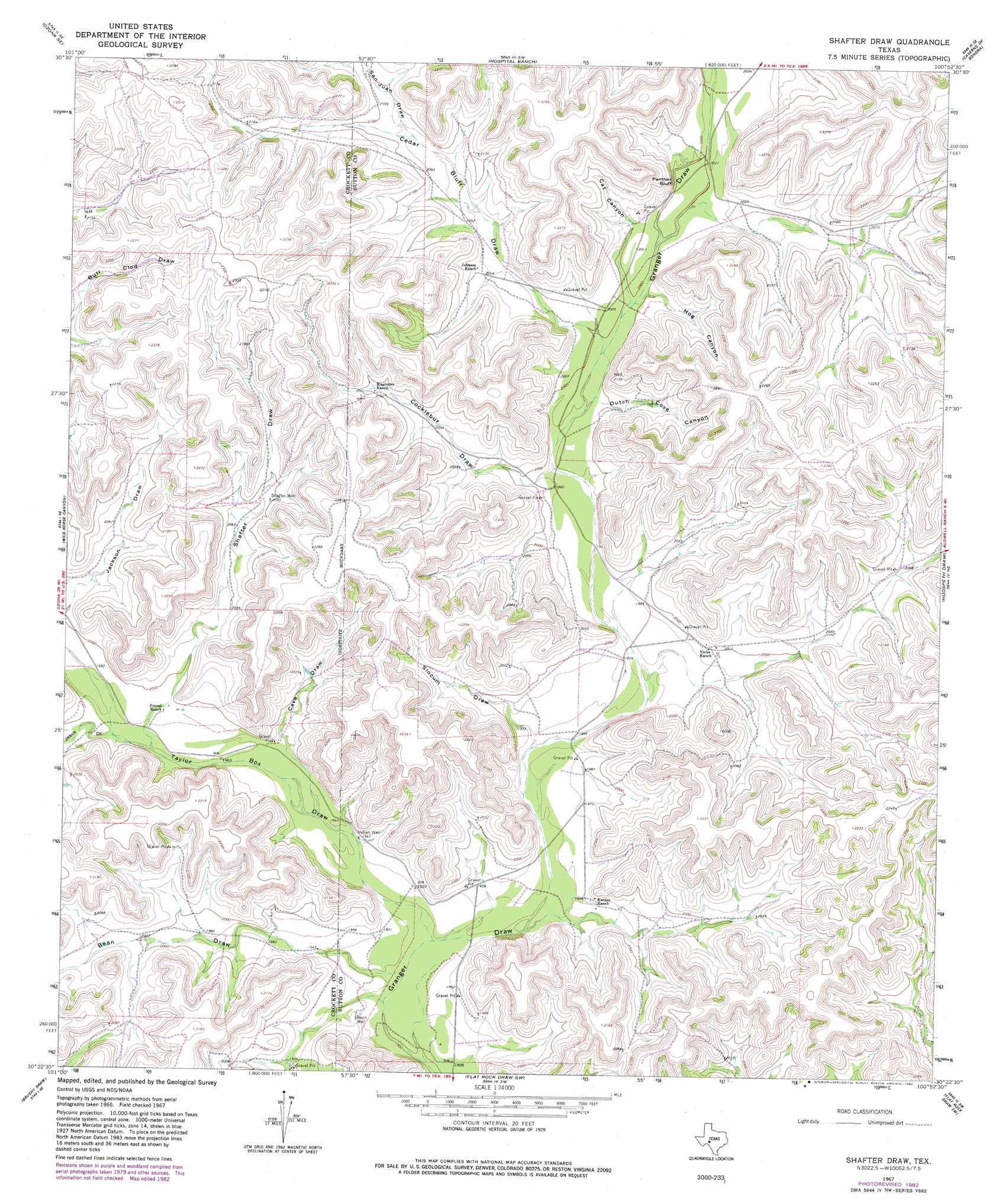
USGS Topo Quad 30100d8 - 1:24,000 scale
| Topo Map Name: | Shafter Draw |
| USGS Topo Quad ID: | 30100d8 |
| Print Size: | ca. 21 1/4" wide x 27" high |
| Southeast Coordinates: | 30.375° N latitude / 100.875° W longitude |
| Map Center Coordinates: | 30.4375° N latitude / 100.9375° W longitude |
| U.S. State: | TX |
| Filename: | o30100d8.jpg |
| Download Map JPG Image: | Shafter Draw topo map 1:24,000 scale |
| Map Type: | Topographic |
| Topo Series: | 7.5´ |
| Map Scale: | 1:24,000 |
| Source of Map Images: | United States Geological Survey (USGS) |
| Alternate Map Versions: |
Shafter Draw TX 1967, updated 1970 Download PDF Buy paper map Shafter Draw TX 1967, updated 1982 Download PDF Buy paper map Shafter Draw TX 2010 Download PDF Buy paper map Shafter Draw TX 2012 Download PDF Buy paper map Shafter Draw TX 2016 Download PDF Buy paper map |
1:24,000 Topo Quads surrounding Shafter Draw
Ozona |
Crockett Heights |
Nolen Draw |
Savell Ranch |
Sonora Nw |
Baggett Ranch |
Ozona Se |
Hospital Ranch |
Caverns Of Sonora |
Sonora |
Harrell Canyon |
Wild Horse Canyon |
Shafter Draw |
Hudspeth Draw |
Dunbar Draw Nw |
Indian Draw |
Brushy Draw |
Flat Rock Draw Sw |
Flat Rock Draw Se |
Dunbar Draw Sw |
Bee Canyon |
Juno |
White Draw Nw |
White Draw Ne |
Turney Draw Nw |
> Back to 30100a1 at 1:100,000 scale
> Back to 30100a1 at 1:250,000 scale
> Back to U.S. Topo Maps home
Shafter Draw topo map: Gazetteer
Shafter Draw: Cliffs
Panther Bluff elevation 614m 2014′Shafter Draw: Valleys
Bean Draw elevation 585m 1919′Cat Canyon elevation 609m 1998′
Cave Draw elevation 596m 1955′
Cedar Bluff Draw elevation 608m 1994′
Cocklebur Draw elevation 603m 1978′
Dutch Cove Canyon elevation 607m 1991′
Hog Canyon elevation 610m 2001′
Jesus Draw elevation 600m 1968′
San Juan Draw elevation 632m 2073′
Shafter Draw elevation 609m 1998′
Slocum Draw elevation 593m 1945′
Taylor Box Draw elevation 582m 1909′
Shafter Draw: Wells
Bean Well elevation 589m 1932′Indian Well elevation 592m 1942′
Shafter Well elevation 639m 2096′
Shafter Draw digital topo map on disk
Buy this Shafter Draw topo map showing relief, roads, GPS coordinates and other geographical features, as a high-resolution digital map file on DVD: