Juno Topo Map Texas
To zoom in, hover over the map of Juno
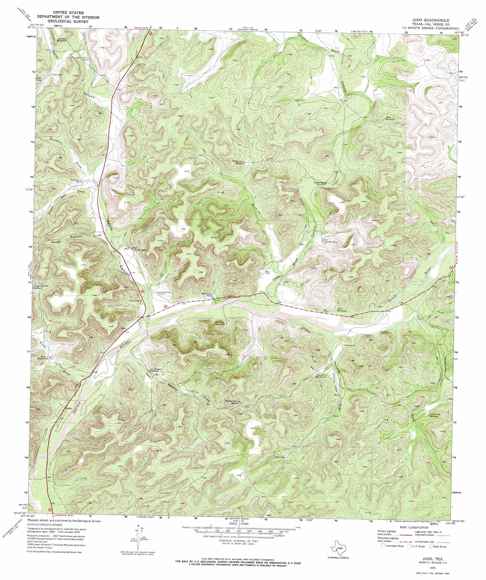
USGS Topo Quad 30101b1 - 1:24,000 scale
| Topo Map Name: | Juno |
| USGS Topo Quad ID: | 30101b1 |
| Print Size: | ca. 21 1/4" wide x 27" high |
| Southeast Coordinates: | 30.125° N latitude / 101° W longitude |
| Map Center Coordinates: | 30.1875° N latitude / 101.0625° W longitude |
| U.S. State: | TX |
| Filename: | o30101b1.jpg |
| Download Map JPG Image: | Juno topo map 1:24,000 scale |
| Map Type: | Topographic |
| Topo Series: | 7.5´ |
| Map Scale: | 1:24,000 |
| Source of Map Images: | United States Geological Survey (USGS) |
| Alternate Map Versions: |
Juno TX 1970, updated 1973 Download PDF Buy paper map Juno TX 2010 Download PDF Buy paper map Juno TX 2012 Download PDF Buy paper map Juno TX 2016 Download PDF Buy paper map |
1:24,000 Topo Quads surrounding Juno
Howards Well Ne |
Harrell Canyon |
Wild Horse Canyon |
Shafter Draw |
Hudspeth Draw |
Aermotor Draw |
Indian Draw |
Brushy Draw |
Flat Rock Draw Sw |
Flat Rock Draw Se |
Steel Star Draw |
Bee Canyon |
Juno |
White Draw Nw |
White Draw Ne |
Blue Hills |
Sycamore Canyon |
Deaton Draw |
White Draw |
Robinson Draw |
Mayfield Canyon |
Bakers Crossing |
Telephone Canyon |
Dolan Springs |
Open Hollow |
> Back to 30101a1 at 1:100,000 scale
> Back to 30100a1 at 1:250,000 scale
> Back to U.S. Topo Maps home
Juno topo map: Gazetteer
Juno: Populated Places
Juno elevation 520m 1706′Juno: Valleys
Cedar Bluff Canyon elevation 527m 1729′Cully Draw elevation 518m 1699′
Pecos Canyon elevation 525m 1722′
Rough Pasture Draw elevation 543m 1781′
Sulfur Well Draw elevation 549m 1801′
Threemile Draw elevation 537m 1761′
Two Section Draw elevation 522m 1712′
Twomile Draw elevation 530m 1738′
Windmill Draw elevation 554m 1817′
Juno: Wells
White Well elevation 581m 1906′Juno digital topo map on disk
Buy this Juno topo map showing relief, roads, GPS coordinates and other geographical features, as a high-resolution digital map file on DVD: