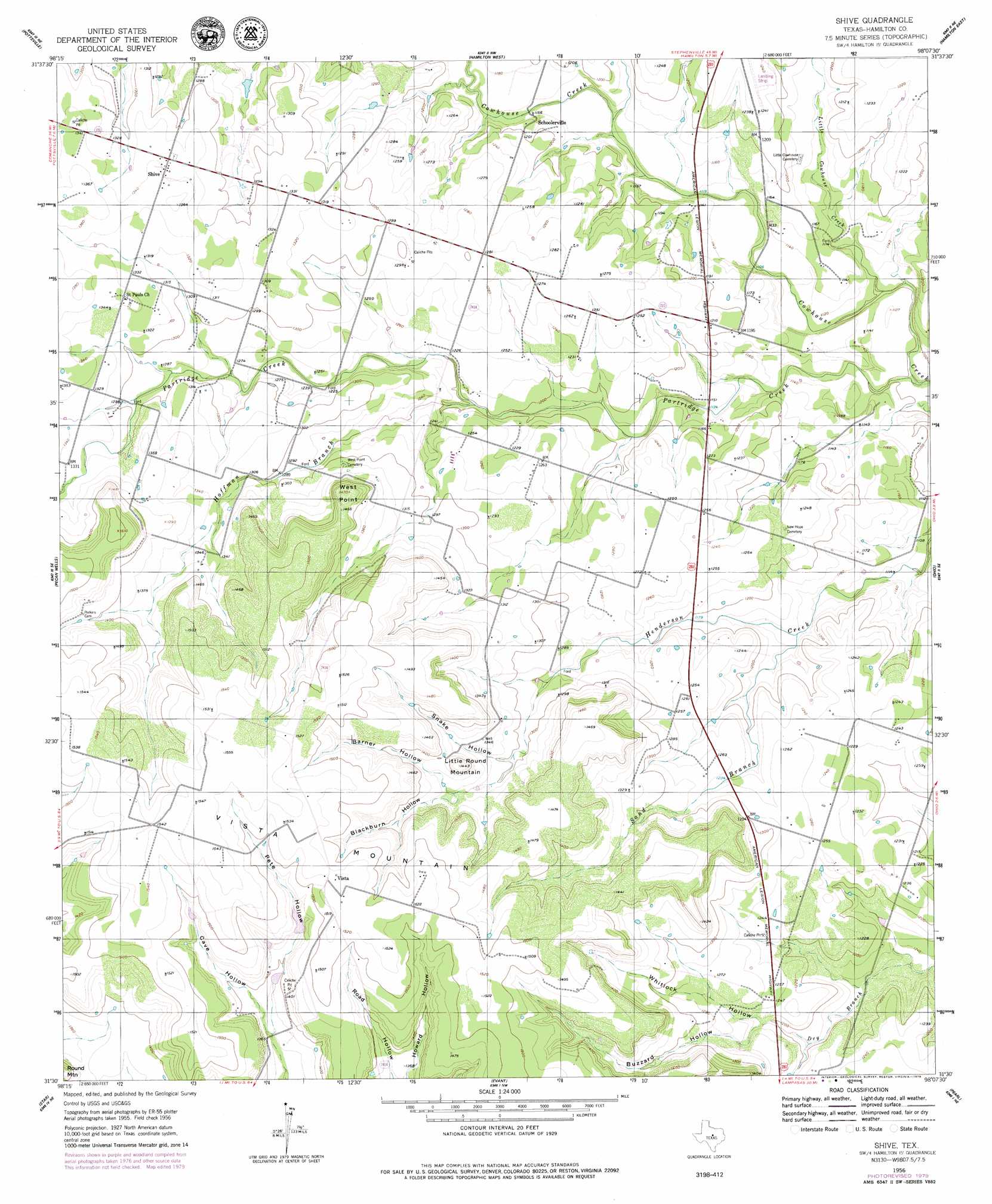
Shive Topo Map Texas
To zoom in, hover over the map of Shive
USGS Topo Quad 31098e2 - 1:24,000 scale
| Topo Map Name: | Shive |
| USGS Topo Quad ID: | 31098e2 |
| Print Size: | ca. 21 1/4" wide x 27" high |
| Southeast Coordinates: | 31.5° N latitude / 98.125° W longitude |
| Map Center Coordinates: | 31.5625° N latitude / 98.1875° W longitude |
| U.S. State: | TX |
| Filename: | o31098e2.jpg |
| Download Map JPG Image: | Shive topo map 1:24,000 scale |
| Map Type: | Topographic |
| Topo Series: | 7.5´ |
| Map Scale: | 1:24,000 |
| Source of Map Images: | United States Geological Survey (USGS) |
| Alternate Map Versions: |
Shive TX 1956, updated 1957 Download PDF Buy paper map Shive TX 2010 Download PDF Buy paper map Shive TX 2012 Download PDF Buy paper map Shive TX 2016 Download PDF Buy paper map |
1:24,000 Topo Quads surrounding Shive
Gustine |
Lamkin |
Gentrys Mill |
Eidson Lake |
Fairy |
Indian Gap |
Pottsville |
Hamilton West |
Hamilton East |
Cutoff Mountain |
Caradan |
Pecan Wells |
Shive |
Ohio |
Jonesboro |
Center City |
Star |
Evant |
Pearl |
Purmela |
Antelope Gap |
Castle Peak |
Adamsville |
Izoro |
Pidcoke |
> Back to 31098e1 at 1:100,000 scale
> Back to 31098a1 at 1:250,000 scale
> Back to U.S. Topo Maps home
Shive topo map: Gazetteer
Shive: Dams
Caldwell Lake Number 1 Dam elevation 436m 1430′Caldwell Lake Number 2 Dam elevation 427m 1400′
Shive: Populated Places
Schoolerville elevation 365m 1197′Shive elevation 408m 1338′
Vista elevation 463m 1519′
Shive: Reservoirs
Caldwell Lake Number 1 elevation 436m 1430′Caldwell Lake Number 2 elevation 427m 1400′
Shive: Streams
Hoffman Branch elevation 365m 1197′Little Cowhouse Creek elevation 335m 1099′
Partridge Creek elevation 329m 1079′
Sand Branch elevation 349m 1145′
Shive: Summits
Little Round Mountain elevation 444m 1456′Vista Mountain elevation 472m 1548′
West Point elevation 449m 1473′
Shive: Valleys
Barner Hollow elevation 416m 1364′Blackburn Hollow elevation 417m 1368′
Buzzard Hollow elevation 369m 1210′
Cave Hollow elevation 408m 1338′
Howard Hollow elevation 414m 1358′
Pete Hollow elevation 418m 1371′
Road Hollow elevation 414m 1358′
Snake Hollow elevation 395m 1295′
Whitlock Hollow elevation 362m 1187′
Shive digital topo map on disk
Buy this Shive topo map showing relief, roads, GPS coordinates and other geographical features, as a high-resolution digital map file on DVD: