Aguila Mountains Se Topo Map Arizona
To zoom in, hover over the map of Aguila Mountains Se
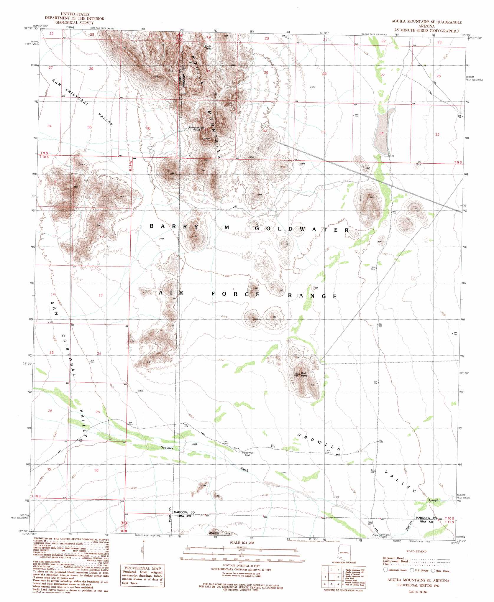
USGS Topo Quad 32113e3 - 1:24,000 scale
| Topo Map Name: | Aguila Mountains Se |
| USGS Topo Quad ID: | 32113e3 |
| Print Size: | ca. 21 1/4" wide x 27" high |
| Southeast Coordinates: | 32.5° N latitude / 113.25° W longitude |
| Map Center Coordinates: | 32.5625° N latitude / 113.3125° W longitude |
| U.S. State: | AZ |
| Filename: | o32113e3.jpg |
| Download Map JPG Image: | Aguila Mountains Se topo map 1:24,000 scale |
| Map Type: | Topographic |
| Topo Series: | 7.5´ |
| Map Scale: | 1:24,000 |
| Source of Map Images: | United States Geological Survey (USGS) |
| Alternate Map Versions: |
Aguila Mountains SE AZ 1990, updated 1990 Download PDF Buy paper map Aguila Mountains SE AZ 2011 Download PDF Buy paper map Aguila Mountains SE AZ 2014 Download PDF Buy paper map |
1:24,000 Topo Quads surrounding Aguila Mountains Se
Dateland |
Aztec Hills |
Aztec Se |
Sentinel |
Sentinel Se |
Hohawk Mountains Ne |
Aguila Mountains Nw |
Aguila Mountains Ne |
South Of Sentinel |
Malpais Hill |
Mohawk Mountains Se |
Aguila Mountains Sw |
Aguila Mountains Se |
Okie Well |
East Pass |
North Of Isla Pinta |
Monreal Well |
Granite Mountains North |
West Of Growler Peak |
Growler Peak |
Isla Pinta |
Bryan Mountains |
Granite Mountains South |
Saguaro Gap Well |
Temporal Pass |
> Back to 32113e1 at 1:100,000 scale
> Back to 32112a1 at 1:250,000 scale
> Back to U.S. Topo Maps home
Aguila Mountains Se topo map: Gazetteer
Aguila Mountains Se: Arches
Aguila Arch elevation 279m 915′Aguila Mountains Se: Reservoirs
Don Diego Tank elevation 286m 938′Eagle Tank elevation 289m 948′
Thompson Tank elevation 248m 813′
Tony Tank elevation 205m 672′
Aguila Mountains Se: Summits
Red Point elevation 354m 1161′Aguila Mountains Se: Valleys
Childs Valley elevation 220m 721′Aguila Mountains Se: Wells
Indian Well elevation 194m 636′Aguila Mountains Se digital topo map on disk
Buy this Aguila Mountains Se topo map showing relief, roads, GPS coordinates and other geographical features, as a high-resolution digital map file on DVD: