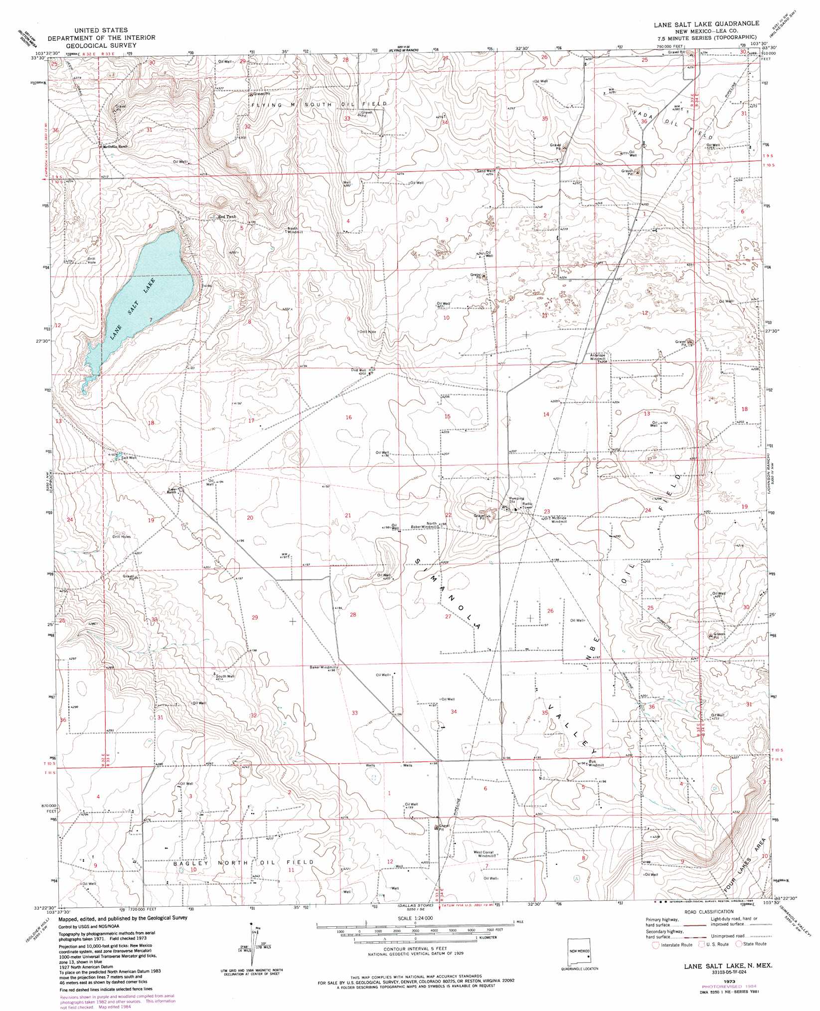
Lane Salt Lake Topo Map New Mexico
To zoom in, hover over the map of Lane Salt Lake
USGS Topo Quad 33103d5 - 1:24,000 scale
| Topo Map Name: | Lane Salt Lake |
| USGS Topo Quad ID: | 33103d5 |
| Print Size: | ca. 21 1/4" wide x 27" high |
| Southeast Coordinates: | 33.375° N latitude / 103.5° W longitude |
| Map Center Coordinates: | 33.4375° N latitude / 103.5625° W longitude |
| U.S. State: | NM |
| Filename: | o33103d5.jpg |
| Download Map JPG Image: | Lane Salt Lake topo map 1:24,000 scale |
| Map Type: | Topographic |
| Topo Series: | 7.5´ |
| Map Scale: | 1:24,000 |
| Source of Map Images: | United States Geological Survey (USGS) |
| Alternate Map Versions: |
Lane Salt Lake NM 1973, updated 1976 Download PDF Buy paper map Lane Salt Lake NM 1973, updated 1985 Download PDF Buy paper map Lane Salt Lake NM 2010 Download PDF Buy paper map Lane Salt Lake NM 2013 Download PDF Buy paper map Lane Salt Lake NM 2017 Download PDF Buy paper map |
1:24,000 Topo Quads surrounding Lane Salt Lake
Lone Wolf |
Button Mesa North |
Button Mesa Ne |
Milnesand Nw |
Milnesand |
Curlew Lake Se |
Button Mesa South |
Flying M Ranch |
Milnesand Sw |
Crossroads |
Mescalero Point Ne |
Caprock |
Lane Salt Lake |
Johnson Ranch |
Ranger Lake |
Mescalero Point |
Soldier Hill |
Dallas Store |
Simanola Valley |
Tatum North |
Caudill Ranch |
Cooper-Good Ranch |
Frier Ranch |
Alston Ranch |
Tatum South |
> Back to 33103a1 at 1:100,000 scale
> Back to 33102a1 at 1:250,000 scale
> Back to U.S. Topo Maps home
Lane Salt Lake topo map: Gazetteer
Lane Salt Lake: Lakes
Lane Salt Lake elevation 1266m 4153′Lane Salt Lake: Oilfields
Inbe Oil Field elevation 1281m 4202′Vada Oil Field elevation 1304m 4278′
Lane Salt Lake: Reservoirs
Red Tank elevation 1273m 4176′Lane Salt Lake: Valleys
Simanola Valley elevation 1278m 4192′Lane Salt Lake: Wells
05000 Water Well elevation 1281m 4202′05002 Water Well elevation 1285m 4215′
05003 Water Well elevation 1282m 4206′
10664 Water Well elevation 1279m 4196′
10667 Water Well elevation 1306m 4284′
10669 Water Well elevation 1283m 4209′
10670 Water Well elevation 1287m 4222′
12516 Water Well elevation 1287m 4222′
12524 Water Well elevation 1310m 4297′
12528 Water Well elevation 1305m 4281′
12529 Water Well elevation 1302m 4271′
12584 Water Well elevation 1287m 4222′
12585 Water Well elevation 1282m 4206′
12586 Water Well elevation 1280m 4199′
12587 Water Well elevation 1280m 4199′
12588 Water Well elevation 1280m 4199′
12589 Water Well elevation 1278m 4192′
12590 Water Well elevation 1279m 4196′
12591 Water Well elevation 1279m 4196′
12592 Water Well elevation 1280m 4199′
12593 Water Well elevation 1283m 4209′
12595 Water Well elevation 1281m 4202′
12596 Water Well elevation 1283m 4209′
12597 Water Well elevation 1280m 4199′
12838 Water Well elevation 1306m 4284′
12862 Water Well elevation 1283m 4209′
12863 Water Well elevation 1276m 4186′
12864 Water Well elevation 1286m 4219′
12865 Water Well elevation 1282m 4206′
13052 Water Well elevation 1279m 4196′
13053 Water Well elevation 1280m 4199′
13175 Water Well elevation 1274m 4179′
13386 Water Well elevation 1280m 4199′
13532 Water Well elevation 1293m 4242′
13533 Water Well elevation 1289m 4229′
13535 Water Well elevation 1300m 4265′
Dug Well elevation 1281m 4202′
Salt Well elevation 1278m 4192′
Sand Well elevation 1297m 4255′
South Well elevation 1285m 4215′
Lane Salt Lake digital topo map on disk
Buy this Lane Salt Lake topo map showing relief, roads, GPS coordinates and other geographical features, as a high-resolution digital map file on DVD: