Taxahaw Topo Map South Carolina
To zoom in, hover over the map of Taxahaw
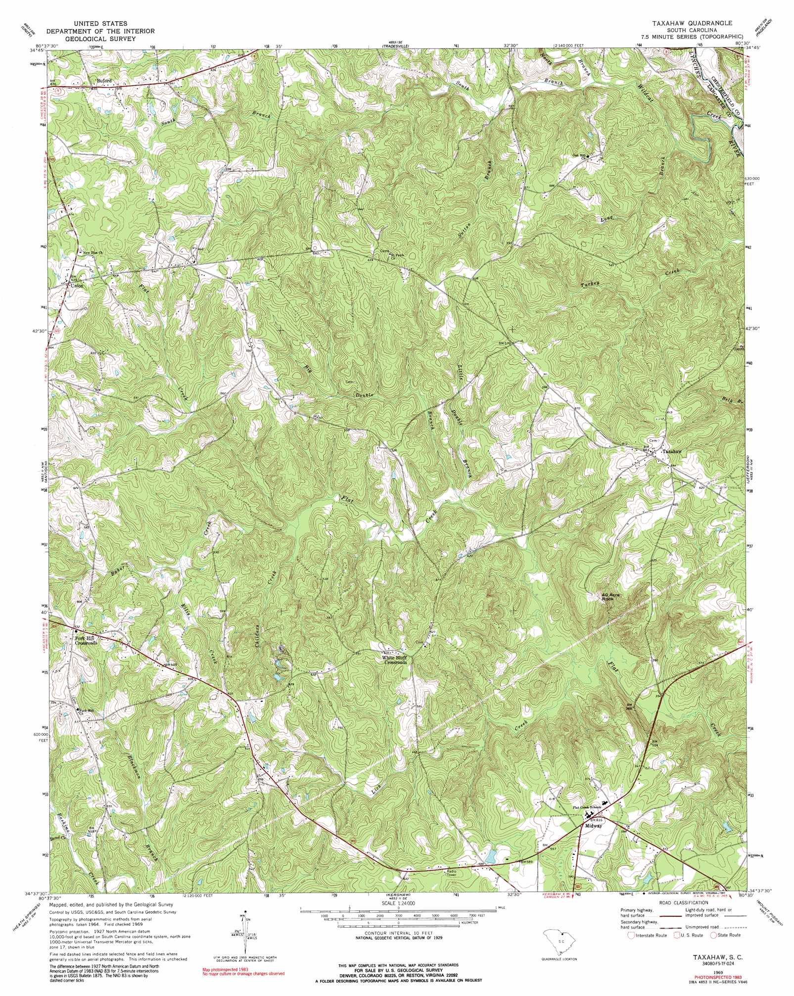
USGS Topo Quad 34080f5 - 1:24,000 scale
| Topo Map Name: | Taxahaw |
| USGS Topo Quad ID: | 34080f5 |
| Print Size: | ca. 21 1/4" wide x 27" high |
| Southeast Coordinates: | 34.625° N latitude / 80.5° W longitude |
| Map Center Coordinates: | 34.6875° N latitude / 80.5625° W longitude |
| U.S. State: | SC |
| Filename: | o34080f5.jpg |
| Download Map JPG Image: | Taxahaw topo map 1:24,000 scale |
| Map Type: | Topographic |
| Topo Series: | 7.5´ |
| Map Scale: | 1:24,000 |
| Source of Map Images: | United States Geological Survey (USGS) |
| Alternate Map Versions: |
Taxahaw SC 1969, updated 1972 Download PDF Buy paper map Taxahaw SC 1969, updated 1991 Download PDF Buy paper map Taxahaw SC 2011 Download PDF Buy paper map Taxahaw SC 2014 Download PDF Buy paper map |
1:24,000 Topo Quads surrounding Taxahaw
Catawba Ne |
Waxhaw |
Monroe |
Wingate |
Marshville |
Van Wyck |
Unity |
Tradesville |
Pageland |
Hornsboro |
Lancaster |
Antioch |
Taxahaw |
Jefferson |
Jefferson Ne |
Lancaster Se |
Heath Springs |
Kershaw |
Mount Pisgah |
Angelus |
Liberty Hill |
Whiteoak Creek |
Westville |
Bethune Nw |
Bethune |
> Back to 34080e1 at 1:100,000 scale
> Back to 34080a1 at 1:250,000 scale
> Back to U.S. Topo Maps home
Taxahaw topo map: Gazetteer
Taxahaw: Dams
Kennington Pond Dam D-1776 elevation 176m 577′Taxahaw: Populated Places
Buford elevation 198m 649′Fork Hill Crossroads elevation 193m 633′
Midway elevation 187m 613′
Taxahaw elevation 201m 659′
Union elevation 194m 636′
White Bluff Corssroads elevation 187m 613′
Taxahaw: Streams
Baker Creek elevation 127m 416′Bend Creek elevation 136m 446′
Big Double Branch elevation 115m 377′
Childers Creek elevation 126m 413′
Ellis Creek elevation 145m 475′
Lick Creek elevation 109m 357′
Little Double Branch elevation 115m 377′
Long Branch elevation 109m 357′
North Branch Wildcat Creek elevation 117m 383′
South Branch Wildcat Creek elevation 117m 383′
Sutton Branch elevation 125m 410′
Wildcat Creek elevation 106m 347′
Taxahaw: Summits
Fourty Acre Rock elevation 176m 577′Taxahaw digital topo map on disk
Buy this Taxahaw topo map showing relief, roads, GPS coordinates and other geographical features, as a high-resolution digital map file on DVD:
South Carolina, Western North Carolina & Northeastern Georgia
Buy digital topo maps: South Carolina, Western North Carolina & Northeastern Georgia