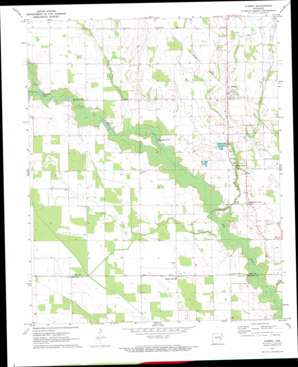
Aubrey Topo Map Arkansas
To zoom in, hover over the map of Aubrey
USGS Topo Quad 34090f8 - 1:24,000 scale
| Topo Map Name: | Aubrey |
| USGS Topo Quad ID: | 34090f8 |
| Print Size: | ca. 21 1/4" wide x 27" high |
| Southeast Coordinates: | 34.625° N latitude / 90.875° W longitude |
| Map Center Coordinates: | 34.6875° N latitude / 90.9375° W longitude |
| U.S. State: | AR |
| Filename: | o34090f8.jpg |
| Download Map JPG Image: | Aubrey topo map 1:24,000 scale |
| Map Type: | Topographic |
| Topo Series: | 7.5´ |
| Map Scale: | 1:24,000 |
| Source of Map Images: | United States Geological Survey (USGS) |
| Alternate Map Versions: |
Aubrey AR 1971, updated 1973 Download PDF Buy paper map Aubrey AR 2011 Download PDF Buy paper map Aubrey AR 2014 Download PDF Buy paper map |
1:24,000 Topo Quads surrounding Aubrey
> Back to 34090e1 at 1:100,000 scale
> Back to 34090a1 at 1:250,000 scale
> Back to U.S. Topo Maps home
Aubrey topo map: Gazetteer
Aubrey: Lakes
Little Mossy Lake elevation 54m 177′McCloud Lake elevation 52m 170′
McNulty Lake elevation 54m 177′
Piney Fork Lake elevation 52m 170′
Aubrey: Populated Places
Aubrey elevation 62m 203′Big Creek Corner elevation 60m 196′
New Hope elevation 62m 203′
Spring Creek elevation 59m 193′
Thomasville elevation 62m 203′
Turkey Scratch elevation 55m 180′
Aubrey: Streams
Cat Creek elevation 56m 183′Little Hog Tusk Creek elevation 54m 177′
Piney Creek elevation 52m 170′
Spring Creek elevation 54m 177′
Aubrey digital topo map on disk
Buy this Aubrey topo map showing relief, roads, GPS coordinates and other geographical features, as a high-resolution digital map file on DVD:


