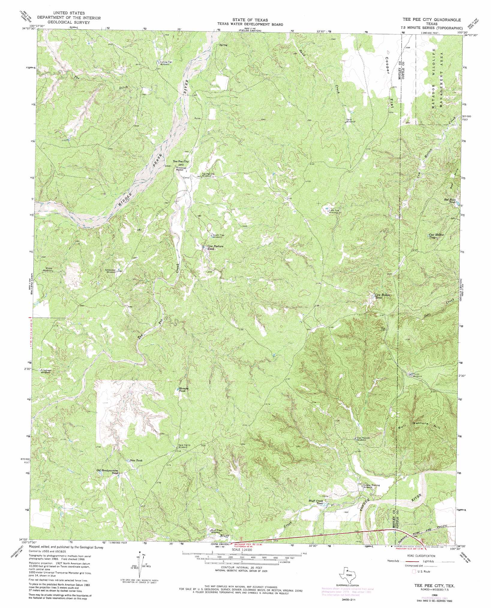
Tee Pee City Topo Map Texas
To zoom in, hover over the map of Tee Pee City
USGS Topo Quad 34100a5 - 1:24,000 scale
| Topo Map Name: | Tee Pee City |
| USGS Topo Quad ID: | 34100a5 |
| Print Size: | ca. 21 1/4" wide x 27" high |
| Southeast Coordinates: | 34° N latitude / 100.5° W longitude |
| Map Center Coordinates: | 34.0625° N latitude / 100.5625° W longitude |
| U.S. State: | TX |
| Filename: | o34100a5.jpg |
| Download Map JPG Image: | Tee Pee City topo map 1:24,000 scale |
| Map Type: | Topographic |
| Topo Series: | 7.5´ |
| Map Scale: | 1:24,000 |
| Source of Map Images: | United States Geological Survey (USGS) |
| Alternate Map Versions: |
Tee Pee City TX 1966, updated 1968 Download PDF Buy paper map Tee Pee City TX 1966, updated 1981 Download PDF Buy paper map Tee Pee City TX 2010 Download PDF Buy paper map Tee Pee City TX 2012 Download PDF Buy paper map Tee Pee City TX 2016 Download PDF Buy paper map |
1:24,000 Topo Quads surrounding Tee Pee City
North Windmill |
Cottonwood Camp |
Northfield |
Tell South |
Hell Roaring Creek |
Hornica Creek |
Turtle Hole Camp |
Fields Canyon |
Cee Vee |
Dunlap |
Matador |
Ballard Camp |
Tee Pee City |
Devils Canyon |
Paducah |
Roaring Springs |
Russellville |
China Canyon |
Grow Nw |
Ginsite |
Afton |
Sanders Hollow |
Dumont |
Buffalo Creek |
Grow |
> Back to 34100a1 at 1:100,000 scale
> Back to 34100a1 at 1:250,000 scale
> Back to U.S. Topo Maps home
Tee Pee City topo map: Gazetteer
Tee Pee City: Reservoirs
Bluff Creek Tank elevation 593m 1945′Cow Hollow Tank elevation 634m 2080′
Cow Hollow Trap elevation 621m 2037′
Cow Pasture Tank elevation 610m 2001′
Humpy Tank elevation 650m 2132′
New Tank elevation 652m 2139′
Old Headquarters Tank elevation 659m 2162′
Red Hills Tank elevation 600m 1968′
Tee Pee City: Streams
Bluff Creek elevation 579m 1899′Tee Pee Creek elevation 586m 1922′
The Ditch elevation 589m 1932′
Tee Pee City: Summits
Bull Pasture Hill elevation 636m 2086′Red Hills elevation 635m 2083′
Tee Pee City digital topo map on disk
Buy this Tee Pee City topo map showing relief, roads, GPS coordinates and other geographical features, as a high-resolution digital map file on DVD: