Okfuskee Topo Map Oklahoma
To zoom in, hover over the map of Okfuskee
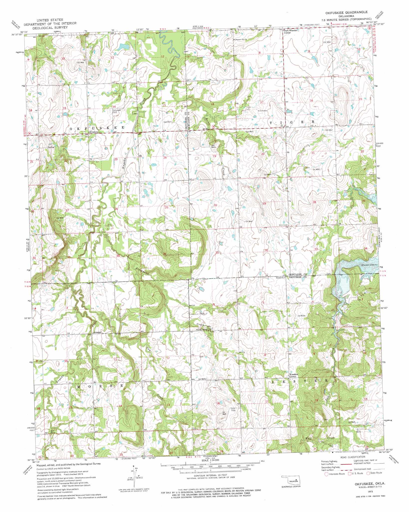
USGS Topo Quad 35096e2 - 1:24,000 scale
| Topo Map Name: | Okfuskee |
| USGS Topo Quad ID: | 35096e2 |
| Print Size: | ca. 21 1/4" wide x 27" high |
| Southeast Coordinates: | 35.5° N latitude / 96.125° W longitude |
| Map Center Coordinates: | 35.5625° N latitude / 96.1875° W longitude |
| U.S. State: | OK |
| Filename: | o35096e2.jpg |
| Download Map JPG Image: | Okfuskee topo map 1:24,000 scale |
| Map Type: | Topographic |
| Topo Series: | 7.5´ |
| Map Scale: | 1:24,000 |
| Source of Map Images: | United States Geological Survey (USGS) |
| Alternate Map Versions: |
Okfuskee OK 1973, updated 1975 Download PDF Buy paper map Okfuskee OK 2010 Download PDF Buy paper map Okfuskee OK 2012 Download PDF Buy paper map Okfuskee OK 2016 Download PDF Buy paper map |
1:24,000 Topo Quads surrounding Okfuskee
Bristow |
Slick |
Kiefer Sw |
Lake Boren |
Spanish Peak |
Gypsy |
Newby |
Nuyaka |
Beggs |
Okmulgee North |
Welty |
Mason |
Okfuskee |
Okmulgee Lake |
Okmulgee South |
Boley |
Okemah |
Clearview |
Pharoah |
Henryetta |
Cromwell |
Okemah Se |
Weleetka |
Dustin |
Henryetta Sw |
> Back to 35096e1 at 1:100,000 scale
> Back to 35096a1 at 1:250,000 scale
> Back to U.S. Topo Maps home
Okfuskee topo map: Gazetteer
Okfuskee: Dams
Okfuskee Tributaries Site N-1 Dam elevation 214m 702′Okfuskee Tributaries Site N-10 Dam elevation 226m 741′
Okfuskee Tributaries Site N-2 Dam elevation 218m 715′
Okfuskee Tributaries Site N-4 Dam elevation 216m 708′
Okfuskee Tributaries Site N6 Dam elevation 229m 751′
Oknoname 107033 Dam elevation 207m 679′
Okfuskee: Populated Places
Okfuskee elevation 217m 711′Oriental elevation 222m 728′
Park Wheeler Corner elevation 225m 738′
Woodard Corner elevation 267m 875′
Okfuskee: Reservoirs
Okfuskee Tributaries Site N-1 Reservoir elevation 214m 702′Okfuskee Tributaries Site N-10 Reservoir elevation 226m 741′
Okfuskee Tributaries Site N-2 Reservoir elevation 218m 715′
Okfuskee Tributaries Site N-4 Reservoir elevation 216m 708′
Okfuskee Tributaries Site N6 Reservoir elevation 229m 751′
Oknoname 107033 Reservoir elevation 207m 679′
Okfuskee: Streams
Brier Creek elevation 235m 770′Cow Creek elevation 213m 698′
Philadelphia Creek elevation 225m 738′
Sixshooter Creek elevation 206m 675′
Wolf Creek elevation 235m 770′
Okfuskee digital topo map on disk
Buy this Okfuskee topo map showing relief, roads, GPS coordinates and other geographical features, as a high-resolution digital map file on DVD: