Elaterite Basin Topo Map Utah
To zoom in, hover over the map of Elaterite Basin
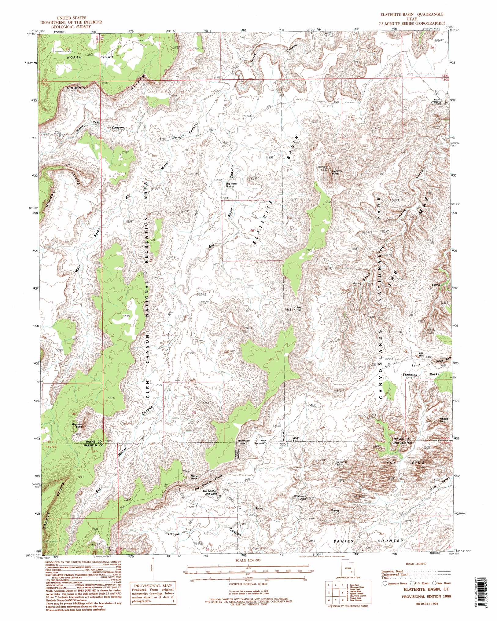
USGS Topo Quad 38110b1 - 1:24,000 scale
| Topo Map Name: | Elaterite Basin |
| USGS Topo Quad ID: | 38110b1 |
| Print Size: | ca. 21 1/4" wide x 27" high |
| Southeast Coordinates: | 38.125° N latitude / 110° W longitude |
| Map Center Coordinates: | 38.1875° N latitude / 110.0625° W longitude |
| U.S. State: | UT |
| Filename: | o38110b1.jpg |
| Download Map JPG Image: | Elaterite Basin topo map 1:24,000 scale |
| Map Type: | Topographic |
| Topo Series: | 7.5´ |
| Map Scale: | 1:24,000 |
| Source of Map Images: | United States Geological Survey (USGS) |
| Alternate Map Versions: |
Orange Cliffs 4 NE UT 1953, updated 1954 Download PDF Buy paper map Elaterite Basin UT 1988, updated 1988 Download PDF Buy paper map Elaterite Basin UT 1988, updated 1995 Download PDF Buy paper map Elaterite Basin UT 1996, updated 2002 Download PDF Buy paper map Elaterite Basin UT 2011 Download PDF Buy paper map Elaterite Basin UT 2014 Download PDF Buy paper map |
1:24,000 Topo Quads surrounding Elaterite Basin
Whitbeck Knoll |
Sugarloaf Butte |
Horsethief Canyon |
Upheaval Dome |
Musselman Arch |
Robbers Roost Flats |
Head Spur |
Cleopatras Chair |
Turks Head |
Monument Basin |
The Pinnacle |
Gordon Flats |
Elaterite Basin |
Spanish Bottom |
The Loop |
Fiddler Butte |
Clearwater Canyon |
Teapot Rock |
Cross Canyon |
Druid Arch |
Sewing Machine |
Bowdie Canyon West |
Bowdie Canyon East |
Fable Valley |
House Park Butte |
> Back to 38110a1 at 1:100,000 scale
> Back to 38110a1 at 1:250,000 scale
> Back to U.S. Topo Maps home
Elaterite Basin topo map: Gazetteer
Elaterite Basin: Arches
Cave Arch elevation 1617m 5305′Tibbett Arch elevation 1634m 5360′
Whitmore Arch elevation 1589m 5213′
Elaterite Basin: Areas
Ernies Country elevation 1511m 4957′The Maze elevation 1566m 5137′
Elaterite Basin: Basins
Elaterite Basin elevation 1557m 5108′Elaterite Basin: Benches
Black Ledge elevation 1726m 5662′Elaterite Basin: Capes
Brimhall Point elevation 1558m 5111′Elaterite Basin: Cliffs
The Wall elevation 1676m 5498′Elaterite Basin: Gaps
China Neck elevation 1824m 5984′The Gap elevation 1742m 5715′
Elaterite Basin: Pillars
The Fins elevation 1666m 5465′The Mother and Child elevation 1657m 5436′
The Wall elevation 1666m 5465′
Elaterite Basin: Ridges
Tapestry Slab elevation 1631m 5351′Elaterite Basin: Springs
Big Water Spring elevation 1556m 5104′Elaterite Basin: Summits
Bagpipe Butte elevation 2008m 6587′Elaterite Butte elevation 1991m 6532′
Lizard Rock elevation 1771m 5810′
Elaterite Basin: Trails
North Trail elevation 1609m 5278′The Golden Stairs elevation 1711m 5613′
Elaterite Basin: Valleys
Big Water Canyon elevation 1523m 4996′Flint Cove elevation 1733m 5685′
North Trail Canyon elevation 1559m 5114′
West Fork Big Water Canyon elevation 1523m 4996′
Wide Valley elevation 1498m 4914′
Wide Valley elevation 1500m 4921′
Elaterite Basin digital topo map on disk
Buy this Elaterite Basin topo map showing relief, roads, GPS coordinates and other geographical features, as a high-resolution digital map file on DVD: