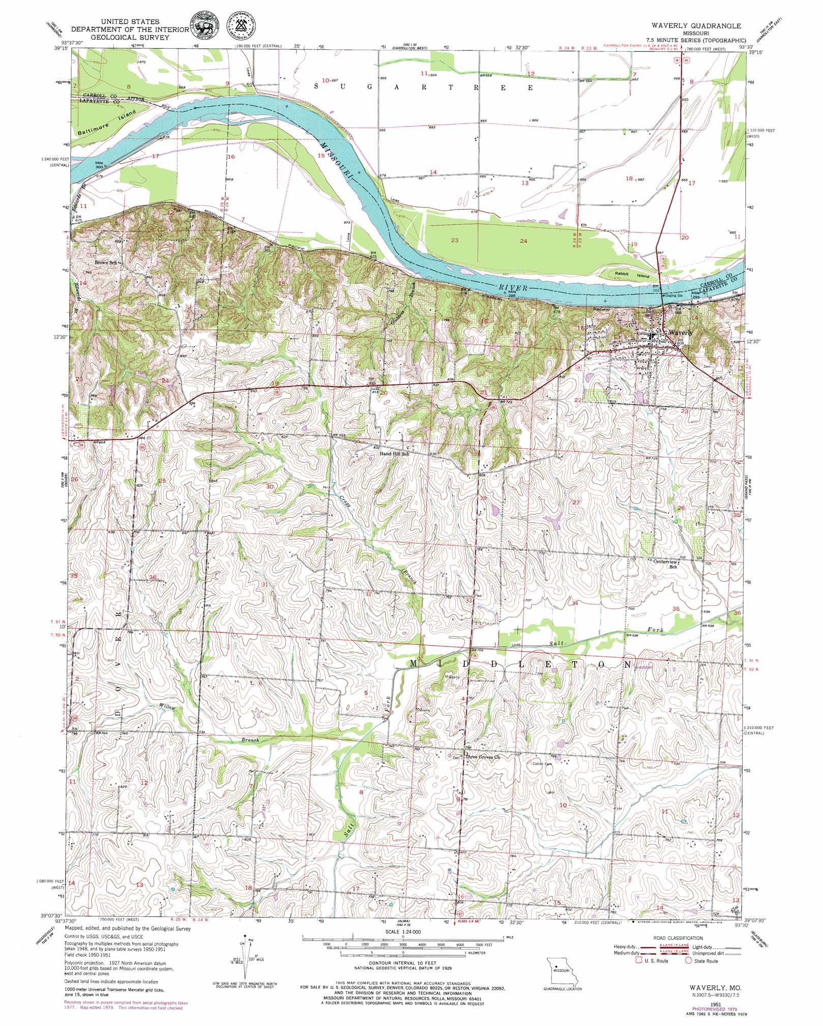
Waverly Topo Map Missouri
To zoom in, hover over the map of Waverly
USGS Topo Quad 39093b5 - 1:24,000 scale
| Topo Map Name: | Waverly |
| USGS Topo Quad ID: | 39093b5 |
| Print Size: | ca. 21 1/4" wide x 27" high |
| Southeast Coordinates: | 39.125° N latitude / 93.5° W longitude |
| Map Center Coordinates: | 39.1875° N latitude / 93.5625° W longitude |
| U.S. State: | MO |
| Filename: | o39093b5.jpg |
| Download Map JPG Image: | Waverly topo map 1:24,000 scale |
| Map Type: | Topographic |
| Topo Series: | 7.5´ |
| Map Scale: | 1:24,000 |
| Source of Map Images: | United States Geological Survey (USGS) |
| Alternate Map Versions: |
Waverly MO 1951, updated 1952 Download PDF Buy paper map Waverly MO 1951, updated 1955 Download PDF Buy paper map Waverly MO 1951, updated 1979 Download PDF Buy paper map Waverly MO 2012 Download PDF Buy paper map Waverly MO 2015 Download PDF Buy paper map |
1:24,000 Topo Quads surrounding Waverly
Stet |
Roads |
Bogard |
Standish |
Bosworth |
Hardin |
Norborne |
Carrollton West |
Carrollton East |
Miami Station |
Lexington East |
Dover |
Waverly |
Grand Pass |
Malta Bend |
Mayview |
Higginsville |
Alma |
Blackburn |
Shackleford |
Fayetteville |
Knob Noster Nw |
Concordia |
Sweet Springs |
Houstonia |
> Back to 39093a1 at 1:100,000 scale
> Back to 39092a1 at 1:250,000 scale
> Back to U.S. Topo Maps home
Waverly topo map: Gazetteer
Waverly: Bends
Hodge Bend elevation 202m 662′Moberly Bend elevation 202m 662′
Waverly Bend elevation 201m 659′
Waverly: Dams
Erdman Lake Dam elevation 230m 754′Higdon Lake Dam elevation 242m 793′
Jones Lake Dam elevation 221m 725′
Pfost Lake Dam elevation 217m 711′
Schmidt Lake Dam elevation 233m 764′
Sidha Farms Lake Dam elevation 255m 836′
Waverly: Islands
Rabbit Island elevation 204m 669′Waverly: Populated Places
Cuba elevation 264m 866′Little Osage Village (historical) elevation 203m 666′
Waverly elevation 248m 813′
Waverly: Streams
Cragg Branch elevation 213m 698′Edwards Branch elevation 203m 666′
Gliddens Branch elevation 201m 659′
Willow Branch elevation 215m 705′
Waverly digital topo map on disk
Buy this Waverly topo map showing relief, roads, GPS coordinates and other geographical features, as a high-resolution digital map file on DVD: