Lexington East Topo Map Missouri
To zoom in, hover over the map of Lexington East
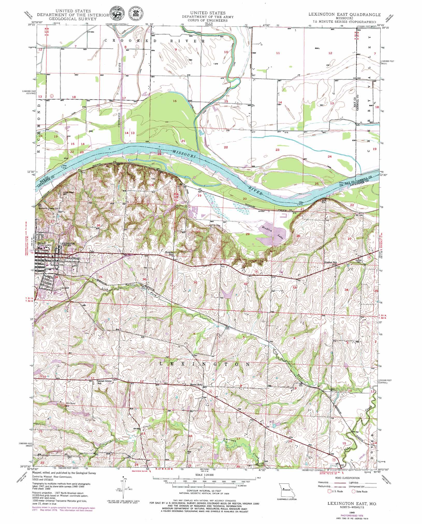
USGS Topo Quad 39093b7 - 1:24,000 scale
| Topo Map Name: | Lexington East |
| USGS Topo Quad ID: | 39093b7 |
| Print Size: | ca. 21 1/4" wide x 27" high |
| Southeast Coordinates: | 39.125° N latitude / 93.75° W longitude |
| Map Center Coordinates: | 39.1875° N latitude / 93.8125° W longitude |
| U.S. State: | MO |
| Filename: | o39093b7.jpg |
| Download Map JPG Image: | Lexington East topo map 1:24,000 scale |
| Map Type: | Topographic |
| Topo Series: | 7.5´ |
| Map Scale: | 1:24,000 |
| Source of Map Images: | United States Geological Survey (USGS) |
| Alternate Map Versions: |
Lexington East MO 1949, updated 1963 Download PDF Buy paper map Lexington East MO 1949, updated 1978 Download PDF Buy paper map Lexington East MO 1949, updated 1979 Download PDF Buy paper map Lexington East MO 1950 Download PDF Buy paper map Lexington East MO 2012 Download PDF Buy paper map Lexington East MO 2015 Download PDF Buy paper map |
1:24,000 Topo Quads surrounding Lexington East
Knoxville |
Millville |
Stet |
Roads |
Bogard |
Rayville |
Richmond |
Hardin |
Norborne |
Carrollton West |
Camden |
Lexington West |
Lexington East |
Dover |
Waverly |
Bates City |
Odessa North |
Mayview |
Higginsville |
Alma |
Chapel Hill |
Odessa South |
Fayetteville |
Knob Noster Nw |
Concordia |
> Back to 39093a1 at 1:100,000 scale
> Back to 39092a1 at 1:250,000 scale
> Back to U.S. Topo Maps home
Lexington East topo map: Gazetteer
Lexington East: Areas
Sauk Prairie elevation 208m 682′Lexington East: Bends
Lexington Bend elevation 206m 675′Sheep Nose Bend elevation 205m 672′
Tabo Bend elevation 205m 672′
Lexington East: Dams
Carter Lake Section 10 Lower Dam elevation 249m 816′Carter Lake Section 10 Upper Dam elevation 258m 846′
Carter Lake Section 11 Dam elevation 239m 784′
Carter Lake Section 25 Lower Dam elevation 221m 725′
Carter Lake Section 25 Upper Dam elevation 227m 744′
Crystal Lakes Dam elevation 254m 833′
Ladys Lake Dam elevation 236m 774′
Lexington City Park Dam elevation 227m 744′
Petsch Dam (historical) elevation 232m 761′
Starke Lake Dam elevation 237m 777′
Tabo Creek Watershed Structure A-22 Dam elevation 221m 725′
Tabo Creek Watershed Structure C-25 Dam elevation 246m 807′
Tabo Creek Watershed Structure C-27 Dam elevation 250m 820′
Tabo Creek Watershed Structure C-28 Dam elevation 240m 787′
Tabo Creek Watershed Structure C-29 Dam elevation 241m 790′
Tabo Creek Watershed Structure C-33 Dam elevation 219m 718′
Tabo Creek Watershed Structure D-20 Dam elevation 230m 754′
Tabo Creek Watershed Structure D-23 Dam elevation 244m 800′
Tabo Creek Watershed Structure D-24 Dam elevation 228m 748′
Tabo Creek Watershed Structure D-26 Dam elevation 220m 721′
Tabo Creek Watershed Structure D-28 Dam elevation 246m 807′
Tabo Creek Watershed Structure D-29 Dam elevation 222m 728′
Tabo Creek Watershed Structure D-30 Dam elevation 221m 725′
Lexington East: Lakes
Hicklin Lake elevation 206m 675′Lexington East: Reservoirs
Dickmeyer Lake elevation 240m 787′Lafayette D10 Lake elevation 230m 754′
Lions Club Lake Number 10298 elevation 227m 744′
Number 140 Reservoir elevation 258m 846′
Number 141 Reservoir elevation 246m 807′
Number 143 Reservoir elevation 222m 728′
Number 185 Reservoir elevation 250m 820′
Palmer Sill Lake elevation 244m 800′
Sam Smiths Lake (historical) elevation 232m 761′
Lexington East: Streams
Crooked River elevation 206m 675′Garrison Creek elevation 210m 688′
Lick Fork elevation 207m 679′
Long Branch elevation 207m 679′
Lexington East digital topo map on disk
Buy this Lexington East topo map showing relief, roads, GPS coordinates and other geographical features, as a high-resolution digital map file on DVD: