Parks Topo Map Nebraska
To zoom in, hover over the map of Parks
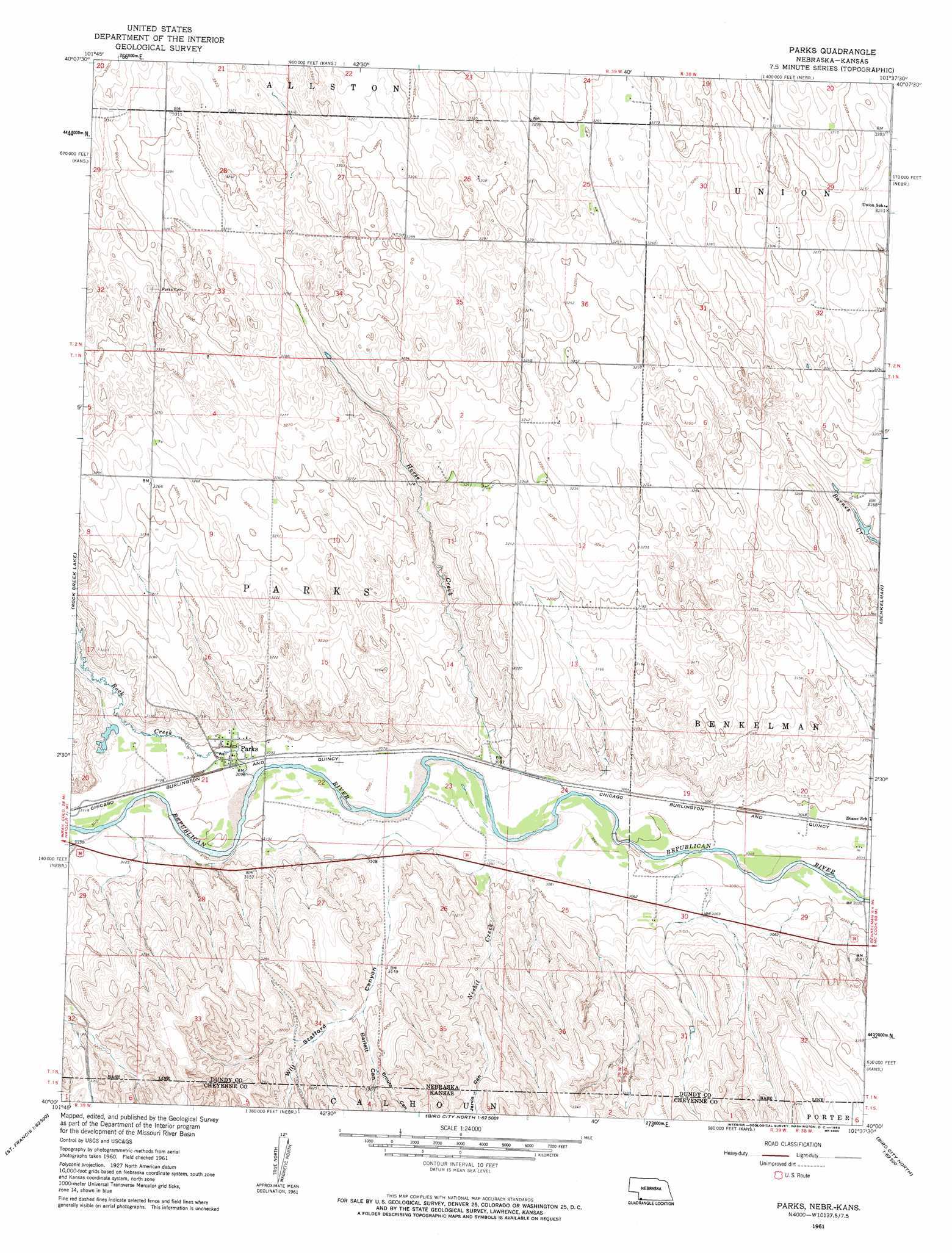
USGS Topo Quad 40101a6 - 1:24,000 scale
| Topo Map Name: | Parks |
| USGS Topo Quad ID: | 40101a6 |
| Print Size: | ca. 21 1/4" wide x 27" high |
| Southeast Coordinates: | 40° N latitude / 101.625° W longitude |
| Map Center Coordinates: | 40.0625° N latitude / 101.6875° W longitude |
| U.S. States: | NE, KS |
| Filename: | O40101a6.jpg |
| Download Map JPG Image: | Parks topo map 1:24,000 scale |
| Map Type: | Topographic |
| Topo Series: | 7.5´ |
| Map Scale: | 1:24,000 |
| Source of Map Images: | United States Geological Survey (USGS) |
| Alternate Map Versions: |
Parks NE 1961, updated 1963 Download PDF Buy paper map Parks NE 2011 Download PDF Buy paper map Parks NE 2014 Download PDF Buy paper map |
1:24,000 Topo Quads surrounding Parks
Reservoir Lake Sw |
Reservoir Lake Se |
Champion Sw |
Ough |
Wauneta Sw |
Haigler Nw |
Haigler Ne |
Benkelman Nw |
Arrowhead Lake |
Rock Canyon |
Haigler |
Rock Creek Lake |
Parks |
Benkelman |
Max |
Saint Francis Nw |
White Canyon |
Heinzelman Canyon |
Henkle Canyon |
Mcdonald Nw |
Saint Francis Sw |
Saint Francis |
Wheeler |
Bird City North |
Mcdonald Sw |
> Back to 40101a1 at 1:100,000 scale
> Back to 40100a1 at 1:250,000 scale
> Back to U.S. Topo Maps home
Parks topo map: Gazetteer
Parks: Populated Places
Parks elevation 943m 3093′Parks: Post Offices
Parks Post Office elevation 943m 3093′Parks: Streams
Horse Creek elevation 932m 3057′Nesbit Creek elevation 933m 3061′
Nesbit Creek elevation 942m 3090′
Rock Creek elevation 942m 3090′
Parks: Valleys
Barlett Canyon elevation 960m 3149′Barlett Canyon elevation 959m 3146′
Jarvis Canyon elevation 947m 3106′
Jarvis Canyon elevation 942m 3090′
Smute Canyon elevation 966m 3169′
Smutz Canyon elevation 968m 3175′
Will Stafford Canyon elevation 947m 3106′
Will Stanfford Canyon elevation 950m 3116′
Parks digital topo map on disk
Buy this Parks topo map showing relief, roads, GPS coordinates and other geographical features, as a high-resolution digital map file on DVD: