Mondamin Topo Map Iowa
To zoom in, hover over the map of Mondamin
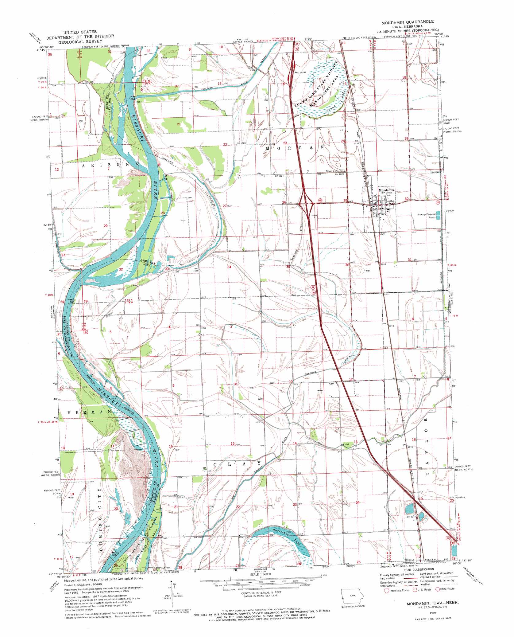
USGS Topo Quad 41096f1 - 1:24,000 scale
| Topo Map Name: | Mondamin |
| USGS Topo Quad ID: | 41096f1 |
| Print Size: | ca. 21 1/4" wide x 27" high |
| Southeast Coordinates: | 41.625° N latitude / 96° W longitude |
| Map Center Coordinates: | 41.6875° N latitude / 96.0625° W longitude |
| U.S. States: | IA, NE |
| Filename: | o41096f1.jpg |
| Download Map JPG Image: | Mondamin topo map 1:24,000 scale |
| Map Type: | Topographic |
| Topo Series: | 7.5´ |
| Map Scale: | 1:24,000 |
| Source of Map Images: | United States Geological Survey (USGS) |
| Alternate Map Versions: |
Mondamin IA 1970, updated 1972 Download PDF Buy paper map Mondamin IA 2010 Download PDF Buy paper map Mondamin IA 2013 Download PDF Buy paper map Mondamin IA 2015 Download PDF Buy paper map |
1:24,000 Topo Quads surrounding Mondamin
Bertha |
Tekamah Nw |
Blencoe |
Moorhead Nw |
Moorhead |
Craig |
Tekamah |
Little Sioux |
Pisgah |
Moorhead Se |
Nickerson Ne |
Herman |
Mondamin |
Missouri Valley Nw |
Logan |
Orum |
Blair |
Modale |
Missouri Valley |
Beebeetown |
Arlington |
Kennard |
Fort Calhoun |
Loveland |
Honey Creek |
> Back to 41096e1 at 1:100,000 scale
> Back to 41096a1 at 1:250,000 scale
> Back to U.S. Topo Maps home
Mondamin topo map: Gazetteer
Mondamin: Bends
Bullard Bluff elevation 307m 1007′Sandy Point Bend elevation 305m 1000′
Sandy Point Bend elevation 305m 1000′
Mondamin: Canals
Burcham Ditch elevation 309m 1013′Old Soldier River Ditch elevation 307m 1007′
Spooner Ditch elevation 311m 1020′
Mondamin: Crossings
Interchange 89 elevation 313m 1026′Mondamin: Lakes
Horseshoe Lake elevation 305m 1000′Horseshoe Lake elevation 305m 1000′
Mondamin: Parks
Missouri Dale Wildlife Area elevation 306m 1003′Mondamin Wildlife Area elevation 313m 1026′
Round Lake State Wildlife Management Area elevation 312m 1023′
Soldier Bend Wildlife Area elevation 307m 1007′
Mondamin: Populated Places
Mondamin elevation 312m 1023′Mondamin: Post Offices
Mondamin Post Office elevation 312m 1023′Mondamin: Reservoirs
Round Lake elevation 312m 1023′Mondamin: Streams
Soldier River elevation 308m 1010′Mondamin digital topo map on disk
Buy this Mondamin topo map showing relief, roads, GPS coordinates and other geographical features, as a high-resolution digital map file on DVD: