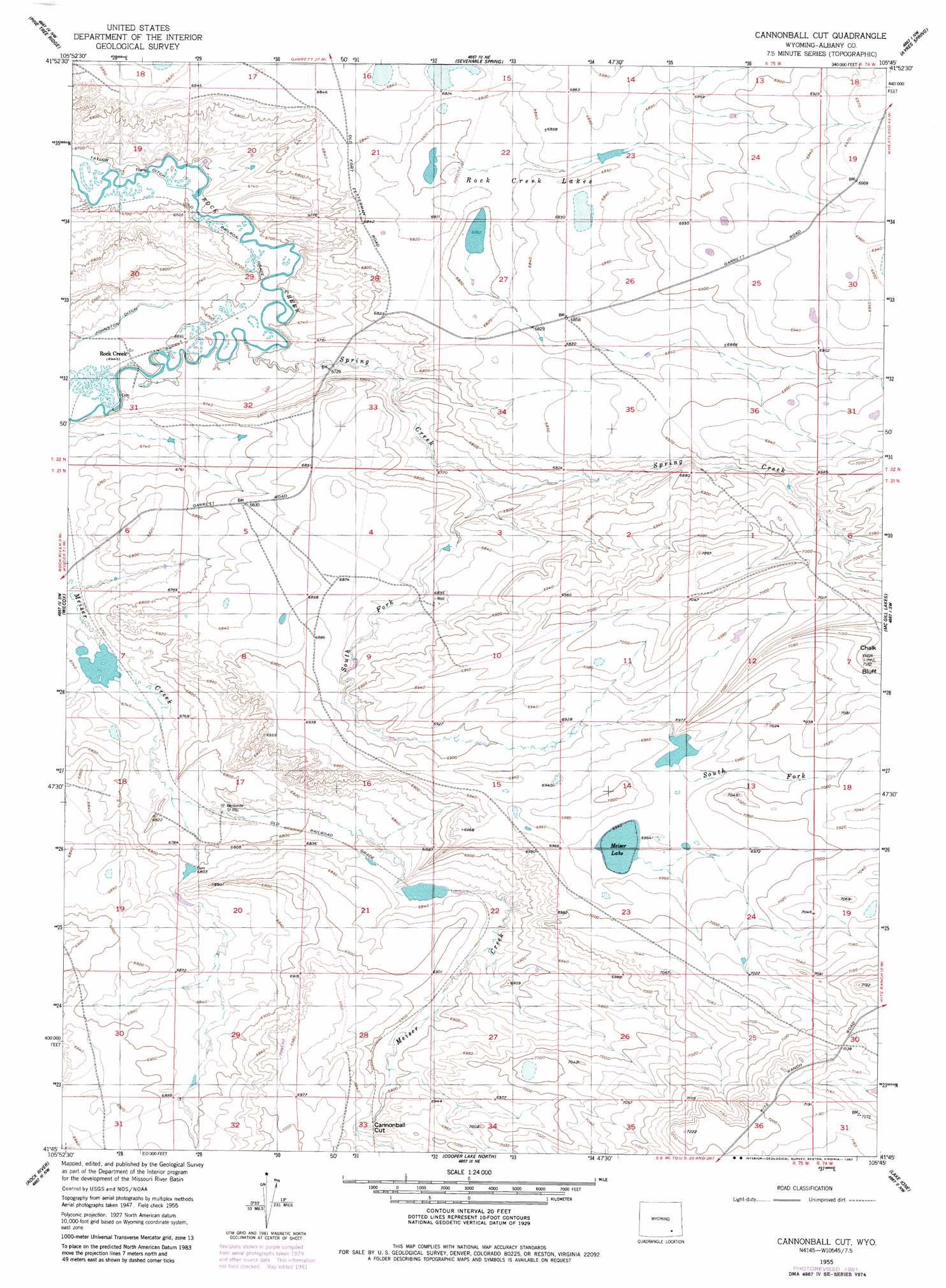
Cannonball Cut Topo Map Wyoming
To zoom in, hover over the map of Cannonball Cut
USGS Topo Quad 41105g7 - 1:24,000 scale
| Topo Map Name: | Cannonball Cut |
| USGS Topo Quad ID: | 41105g7 |
| Print Size: | ca. 21 1/4" wide x 27" high |
| Southeast Coordinates: | 41.75° N latitude / 105.75° W longitude |
| Map Center Coordinates: | 41.8125° N latitude / 105.8125° W longitude |
| U.S. State: | WY |
| Filename: | o41105g7.jpg |
| Download Map JPG Image: | Cannonball Cut topo map 1:24,000 scale |
| Map Type: | Topographic |
| Topo Series: | 7.5´ |
| Map Scale: | 1:24,000 |
| Source of Map Images: | United States Geological Survey (USGS) |
| Alternate Map Versions: |
Cannonball Cut WY 1955, updated 1957 Download PDF Buy paper map Cannonball Cut WY 1955, updated 1982 Download PDF Buy paper map Cannonball Cut WY 2012 Download PDF Buy paper map Cannonball Cut WY 2015 Download PDF Buy paper map |
1:24,000 Topo Quads surrounding Cannonball Cut
Walker Draw Se |
Greasewood Knoll |
Boot Heel Se |
Pinto Creek |
Garrett |
Aurora Lake |
Pine Tree Ridge |
Sevenmile Spring |
Ayres Spring |
Dodge Ranch |
Foote Creek Lake |
Wilcox |
Cannonball Cut |
Mcgill Lakes |
Bluegrass Wells |
Pierce Reservoir |
Rock River |
Cooper Lake North |
Lake Ione |
Sybille Springs |
Bengough Hill |
Big Judson |
Cooper Lake South |
Bosler |
Bosler Se |
> Back to 41105e1 at 1:100,000 scale
> Back to 41104a1 at 1:250,000 scale
> Back to U.S. Topo Maps home
Cannonball Cut topo map: Gazetteer
Cannonball Cut: Canals
Johnston Ditch elevation 2049m 6722′Taylor Ditch elevation 2039m 6689′
Cannonball Cut: Gaps
Cannonball Cut elevation 2116m 6942′Cannonball Cut: Lakes
Meiser Lake elevation 2117m 6945′Rock Creek Lakes elevation 2075m 6807′
Cannonball Cut: Mines
Linscott Claim elevation 2131m 6991′McGill Anticline Mine elevation 2141m 7024′
Taylor Mine elevation 2061m 6761′
Cannonball Cut: Populated Places
Rock Creek (historical) elevation 2045m 6709′Cannonball Cut: Streams
South Fork Spring Creek elevation 2065m 6774′Spring Creek elevation 2043m 6702′
Cannonball Cut: Summits
Chalk Bluff elevation 2184m 7165′Cannonball Cut digital topo map on disk
Buy this Cannonball Cut topo map showing relief, roads, GPS coordinates and other geographical features, as a high-resolution digital map file on DVD:
Eastern Wyoming & Western South Dakota
Buy digital topo maps: Eastern Wyoming & Western South Dakota