Aspen Lake Topo Map Oregon
To zoom in, hover over the map of Aspen Lake
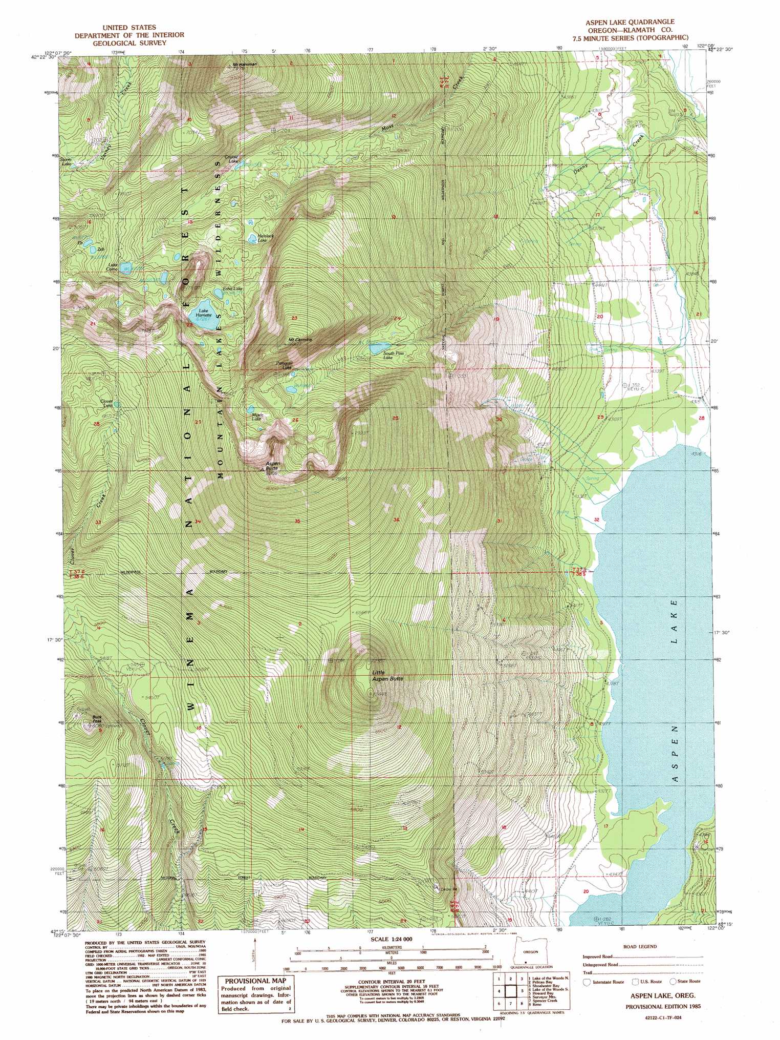
USGS Topo Quad 42122c1 - 1:24,000 scale
| Topo Map Name: | Aspen Lake |
| USGS Topo Quad ID: | 42122c1 |
| Print Size: | ca. 21 1/4" wide x 27" high |
| Southeast Coordinates: | 42.25° N latitude / 122° W longitude |
| Map Center Coordinates: | 42.3125° N latitude / 122.0625° W longitude |
| U.S. State: | OR |
| Filename: | o42122c1.jpg |
| Download Map JPG Image: | Aspen Lake topo map 1:24,000 scale |
| Map Type: | Topographic |
| Topo Series: | 7.5´ |
| Map Scale: | 1:24,000 |
| Source of Map Images: | United States Geological Survey (USGS) |
| Alternate Map Versions: |
Aspen Lake OR 1985, updated 1985 Download PDF Buy paper map Aspen Lake OR 1998, updated 2000 Download PDF Buy paper map Aspen Lake OR 2011 Download PDF Buy paper map Aspen Lake OR 2014 Download PDF Buy paper map |
| FStopo: | US Forest Service topo Aspen Lake is available: Download FStopo PDF Download FStopo TIF |
1:24,000 Topo Quads surrounding Aspen Lake
Rustler Peak |
Pelican Butte |
Crystal Spring |
Agency Lake |
Chiloquin |
Mount Mcloughlin |
Lake Of The Woods North |
Pelican Bay |
Shoalwater Bay |
Modoc Point |
Brown Mountain |
Lake Of The Woods South |
Aspen Lake |
Howard Bay |
Wocus |
Little Chinquapin Mountain |
Surveyor Mountain |
Spencer Creek |
Keno |
Klamath Falls |
Parker Mountain |
Mule Hill |
Chicken Hills |
Hamaker Mountain |
Worden |
> Back to 42122a1 at 1:100,000 scale
> Back to 42122a1 at 1:250,000 scale
> Back to U.S. Topo Maps home
Aspen Lake topo map: Gazetteer
Aspen Lake: Gaps
South Pass elevation 2014m 6607′Aspen Lake: Lakes
Aspen Lake elevation 1315m 4314′Clover Lake elevation 2048m 6719′
Coyote Lake elevation 1873m 6145′
Eb Lake elevation 2065m 6774′
Echo Lake elevation 2037m 6683′
Hemlock Lake elevation 1950m 6397′
Lake Como elevation 1993m 6538′
Lake Harriette elevation 2051m 6729′
Mystic Lake elevation 2212m 7257′
Paragon Lake elevation 2123m 6965′
South Pass Lake elevation 1986m 6515′
Storm Lake elevation 1983m 6505′
Zeb Lake elevation 2063m 6768′
Aspen Lake: Mines
Aspen Butte Cinder Pit elevation 1620m 5314′Aspen Lake Cinder Pit elevation 1616m 5301′
Aspen Lake: Ranges
Grampian Hills elevation 1840m 6036′Aspen Lake: Streams
Bridge Creek elevation 1317m 4320′Camp Creek elevation 1317m 4320′
Denny Creek elevation 1268m 4160′
South Creek elevation 1316m 4317′
Swan Creek elevation 1317m 4320′
Aspen Lake: Summits
Aspen Butte elevation 2503m 8211′Buck Peak elevation 1849m 6066′
Little Aspen Butte elevation 2192m 7191′
Mount Carmine elevation 2396m 7860′
Mount Harriman elevation 2401m 7877′
Aspen Lake: Swamps
Doaks Marsh elevation 1267m 4156′Aspen Lake: Trails
Moss Creek Trail elevation 1889m 6197′South Pass Lake Trail elevation 1960m 6430′
Aspen Lake digital topo map on disk
Buy this Aspen Lake topo map showing relief, roads, GPS coordinates and other geographical features, as a high-resolution digital map file on DVD: