New Richland Topo Map Minnesota
To zoom in, hover over the map of New Richland
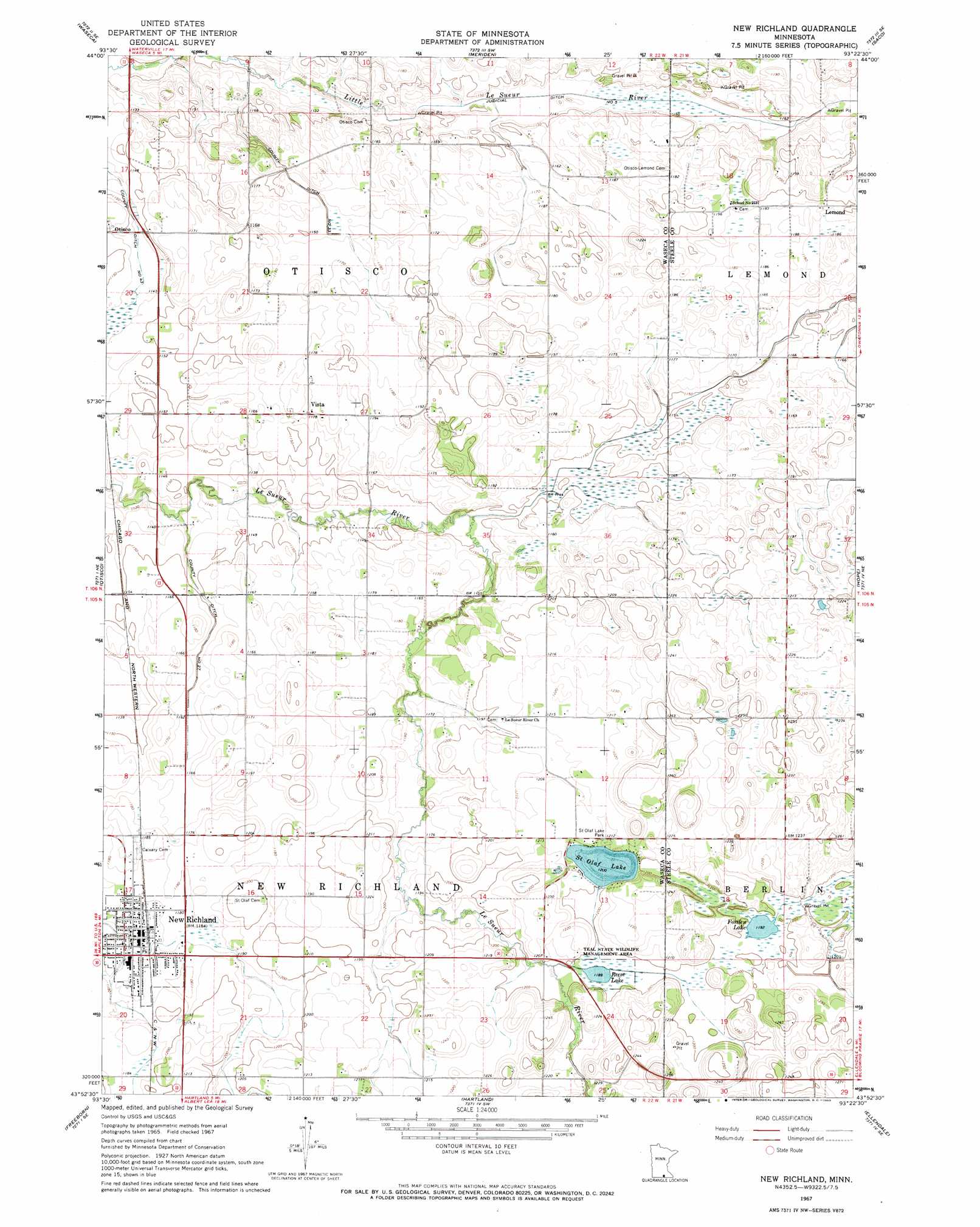
USGS Topo Quad 43093h4 - 1:24,000 scale
| Topo Map Name: | New Richland |
| USGS Topo Quad ID: | 43093h4 |
| Print Size: | ca. 21 1/4" wide x 27" high |
| Southeast Coordinates: | 43.875° N latitude / 93.375° W longitude |
| Map Center Coordinates: | 43.9375° N latitude / 93.4375° W longitude |
| U.S. State: | MN |
| Filename: | o43093h4.jpg |
| Download Map JPG Image: | New Richland topo map 1:24,000 scale |
| Map Type: | Topographic |
| Topo Series: | 7.5´ |
| Map Scale: | 1:24,000 |
| Source of Map Images: | United States Geological Survey (USGS) |
| Alternate Map Versions: |
New Richland MN 1967, updated 1969 Download PDF Buy paper map New Richland MN 2010 Download PDF Buy paper map New Richland MN 2013 Download PDF Buy paper map New Richland MN 2016 Download PDF Buy paper map |
1:24,000 Topo Quads surrounding New Richland
Elysian |
Waterville |
Morristown |
Medford West |
Medford East |
Janesville |
Waseca |
Meriden |
Saco |
Owatonna |
Waldorf |
Otisco |
New Richland |
Hope |
Steele Center |
Matawan |
Freeborn |
Hartland |
Ellendale |
Hollandale |
Wells |
Alden |
Albert Lea West |
Albert Lea East |
Hayward |
> Back to 43093e1 at 1:100,000 scale
> Back to 43092a1 at 1:250,000 scale
> Back to U.S. Topo Maps home
New Richland topo map: Gazetteer
New Richland: Canals
County Ditch Number Thirtythree elevation 351m 1151′County Ditch Number Twentyseven elevation 351m 1151′
Judicial Ditch Number Five elevation 344m 1128′
New Richland: Dams
Saint Olaf Lake Dam elevation 366m 1200′New Richland: Lakes
Fosilen Lake elevation 363m 1190′Reese Lake elevation 362m 1187′
Saint Olaf Lake elevation 366m 1200′
New Richland: Parks
Saint Olaf Lake Park elevation 369m 1210′Teal State Wildlife Management Area elevation 363m 1190′
New Richland: Populated Places
Lemond elevation 364m 1194′New Richland elevation 360m 1181′
Vista elevation 358m 1174′
New Richland: Post Offices
Lemond Post Office (historical) elevation 364m 1194′New Richland Post Office elevation 360m 1181′
Vista Post Office (historical) elevation 358m 1174′
New Richland: Reservoirs
Saint Olaf Lake elevation 366m 1200′New Richland digital topo map on disk
Buy this New Richland topo map showing relief, roads, GPS coordinates and other geographical features, as a high-resolution digital map file on DVD: