Lake Elizabeth Topo Map Minnesota
To zoom in, hover over the map of Lake Elizabeth
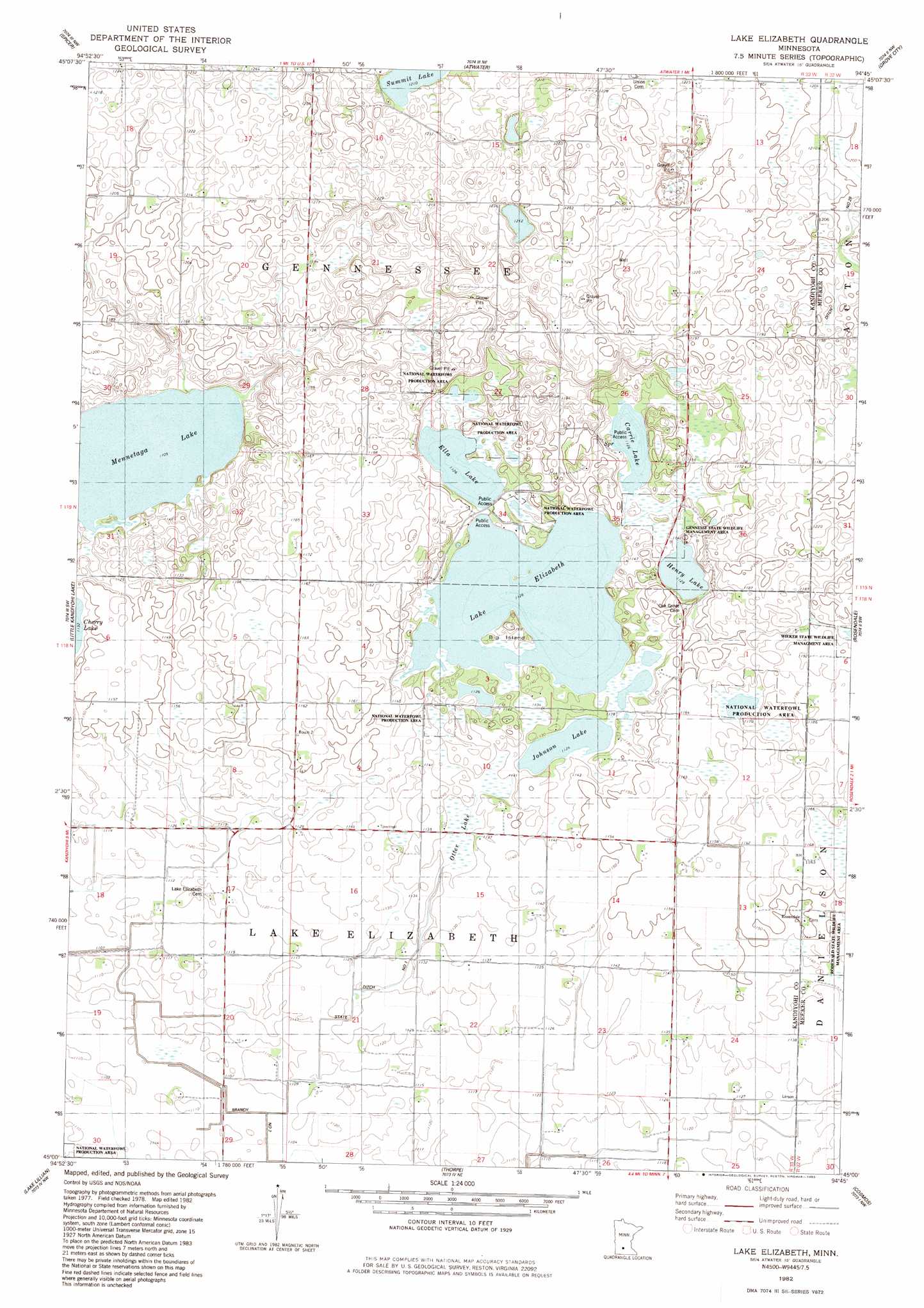
USGS Topo Quad 45094a7 - 1:24,000 scale
| Topo Map Name: | Lake Elizabeth |
| USGS Topo Quad ID: | 45094a7 |
| Print Size: | ca. 21 1/4" wide x 27" high |
| Southeast Coordinates: | 45° N latitude / 94.75° W longitude |
| Map Center Coordinates: | 45.0625° N latitude / 94.8125° W longitude |
| U.S. State: | MN |
| Filename: | o45094a7.jpg |
| Download Map JPG Image: | Lake Elizabeth topo map 1:24,000 scale |
| Map Type: | Topographic |
| Topo Series: | 7.5´ |
| Map Scale: | 1:24,000 |
| Source of Map Images: | United States Geological Survey (USGS) |
| Alternate Map Versions: |
Lake Elizabeth MN 1982, updated 1983 Download PDF Buy paper map Lake Elizabeth MN 2010 Download PDF Buy paper map Lake Elizabeth MN 2013 Download PDF Buy paper map Lake Elizabeth MN 2016 Download PDF Buy paper map |
1:24,000 Topo Quads surrounding Lake Elizabeth
Mount Tom |
New London |
Hawick |
Lake Koronis |
Eden Valley |
Solomon Lake |
Spicer |
Atwater |
Grove City |
Litchfield North |
Willmar |
Little Kandiyohi Lake |
Lake Elizabeth |
Rosendale |
Litchfield South |
Blomkest |
Lake Lillian |
Thorpe |
Cosmos |
Cedar Mills |
Danube |
Olivia |
Olivia Se |
Churchill |
Lake Allie |
> Back to 45094a1 at 1:100,000 scale
> Back to 45094a1 at 1:250,000 scale
> Back to U.S. Topo Maps home
Lake Elizabeth topo map: Gazetteer
Lake Elizabeth: Canals
Branch Number Two elevation 335m 1099′County Ditch Number Twentyeight elevation 363m 1190′
State Ditch Number One elevation 341m 1118′
Lake Elizabeth: Islands
Big Island elevation 349m 1145′Lake Elizabeth: Lakes
Carrie Lake elevation 342m 1122′Charlotte Lake elevation 338m 1108′
Ella Lake elevation 342m 1122′
Henry Lake elevation 342m 1122′
Johnson Lake elevation 342m 1122′
Lake Elizabeth elevation 342m 1122′
Mennetaga Lake elevation 336m 1102′
Otter Lake elevation 345m 1131′
Lake Elizabeth: Parks
Gennesse State Wildlife Management Area elevation 348m 1141′Lake Elizabeth digital topo map on disk
Buy this Lake Elizabeth topo map showing relief, roads, GPS coordinates and other geographical features, as a high-resolution digital map file on DVD: