Ortonville Topo Map Minnesota
To zoom in, hover over the map of Ortonville
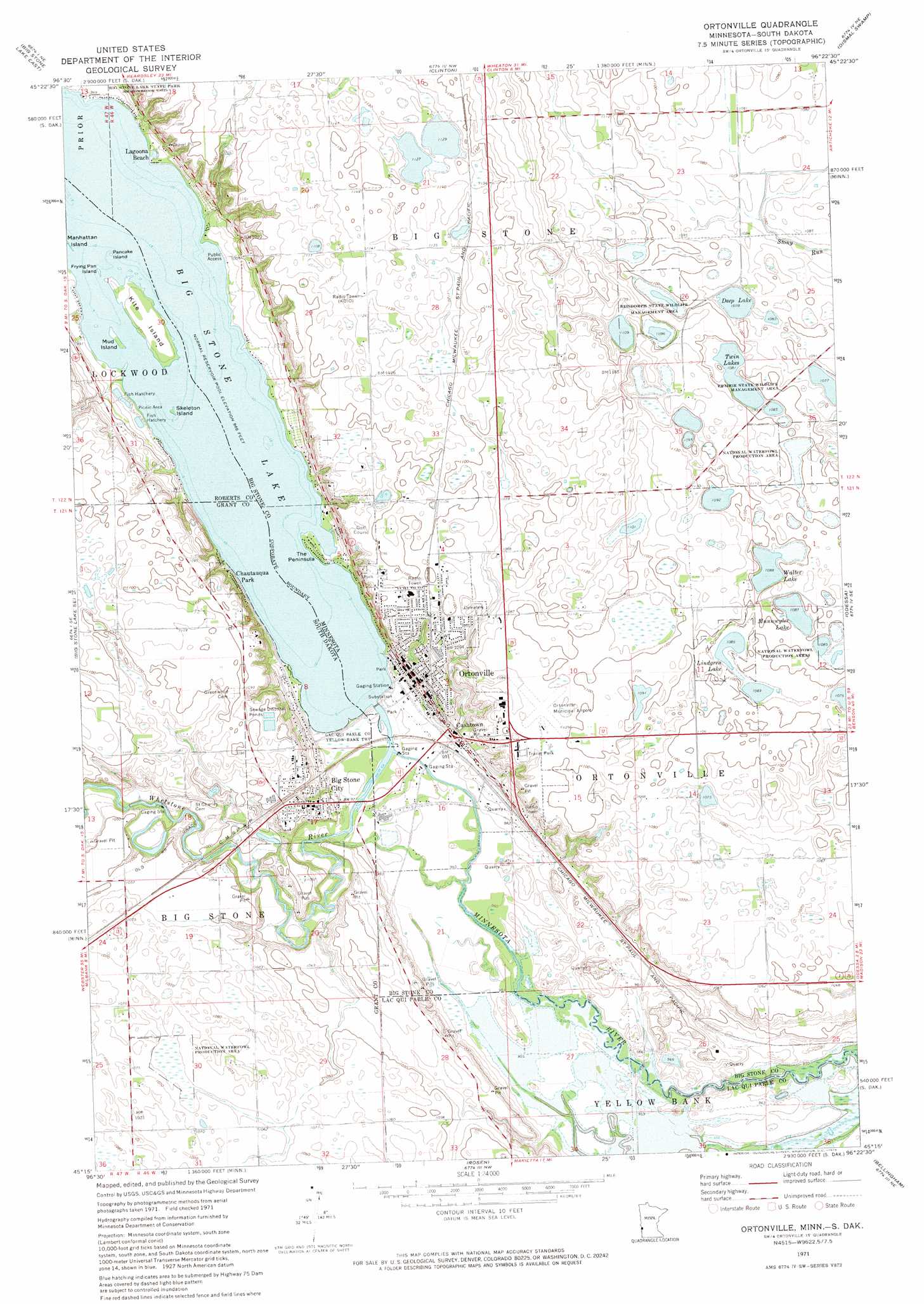
USGS Topo Quad 45096c4 - 1:24,000 scale
| Topo Map Name: | Ortonville |
| USGS Topo Quad ID: | 45096c4 |
| Print Size: | ca. 21 1/4" wide x 27" high |
| Southeast Coordinates: | 45.25° N latitude / 96.375° W longitude |
| Map Center Coordinates: | 45.3125° N latitude / 96.4375° W longitude |
| U.S. States: | MN, SD |
| Filename: | o45096c4.jpg |
| Download Map JPG Image: | Ortonville topo map 1:24,000 scale |
| Map Type: | Topographic |
| Topo Series: | 7.5´ |
| Map Scale: | 1:24,000 |
| Source of Map Images: | United States Geological Survey (USGS) |
| Alternate Map Versions: |
Ortonville MN 1971, updated 1974 Download PDF Buy paper map Ortonville MN 2010 Download PDF Buy paper map Ortonville MN 2013 Download PDF Buy paper map Ortonville MN 2016 Download PDF Buy paper map |
1:24,000 Topo Quads surrounding Ortonville
Beardsley |
Barry |
Graceville |
Johnson |
Chokio |
Big Stone Lake West |
Big Stone Lake East |
Clinton |
Dismal Swamp |
Artichoke Lake Nw |
Big Stone Lake Sw |
Big Stone Lake Se |
Ortonville |
Odessa |
Artichoke Lake |
Milbank West |
Milbank East |
Rosen |
Bellingham |
Correll |
La Bolt |
Revillo |
Marietta |
Haydenville |
Madison |
> Back to 45096a1 at 1:100,000 scale
> Back to 45096a1 at 1:250,000 scale
> Back to U.S. Topo Maps home
Ortonville topo map: Gazetteer
Ortonville: Airports
Ortonville Municipal Airport-Martinson Field elevation 335m 1099′Ortonville: Capes
The Peninsula elevation 296m 971′Ortonville: Dams
Big Stone Lake Dam elevation 295m 967′Ortonville: Islands
Frying Pan Island elevation 295m 967′Kite Island elevation 296m 971′
Mud Island elevation 295m 967′
Pancake Island elevation 295m 967′
Skeleton Island elevation 295m 967′
Ortonville: Lakes
Deep Lake elevation 329m 1079′Lindgren Lake elevation 331m 1085′
Munnwyler Lake elevation 332m 1089′
Twin Lakes elevation 330m 1082′
Walter Lake elevation 332m 1089′
Ortonville: Parks
Central Park elevation 314m 1030′Cliffs Park elevation 326m 1069′
Lakeside Park elevation 298m 977′
Nielson Park elevation 333m 1092′
Northside Park elevation 333m 1092′
Ortonville Region Historical Marker elevation 333m 1092′
Peninsula Park elevation 295m 967′
Reisdorph State Wildlife Management Area elevation 338m 1108′
Riverside Park elevation 296m 971′
Sioux Historic Park elevation 299m 980′
State Line - Ortonville Wayside Park elevation 296m 971′
Ortonville: Populated Places
Big Stone City elevation 318m 1043′Cashtown elevation 304m 997′
Hilltop Manor Mobile Home Park elevation 333m 1092′
Hilltop Manor Mobile Home Park elevation 333m 1092′
Lagoona Beach elevation 296m 971′
Ortonville elevation 310m 1017′
Ortonville: Post Offices
Ortonville Post Office elevation 310m 1017′Ortonville: Reservoirs
Big Stone Lake elevation 295m 967′Ortonville: Streams
Whetstone River elevation 297m 974′Ortonville digital topo map on disk
Buy this Ortonville topo map showing relief, roads, GPS coordinates and other geographical features, as a high-resolution digital map file on DVD:
Eastern North Dakota & Eastern South Dakota
Buy digital topo maps: Eastern North Dakota & Eastern South Dakota