Big Stone Lake West Topo Map Minnesota
To zoom in, hover over the map of Big Stone Lake West
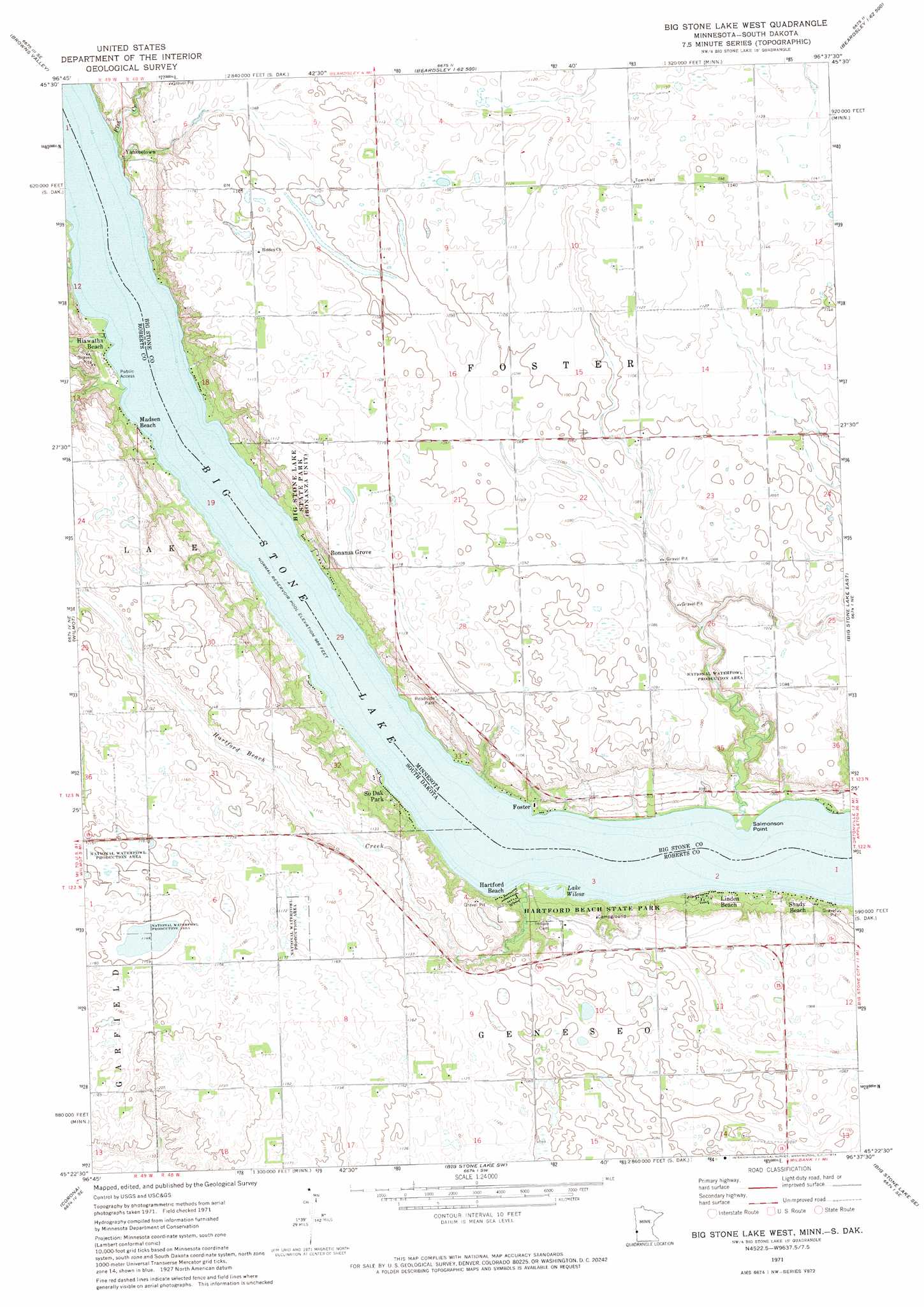
USGS Topo Quad 45096d6 - 1:24,000 scale
| Topo Map Name: | Big Stone Lake West |
| USGS Topo Quad ID: | 45096d6 |
| Print Size: | ca. 21 1/4" wide x 27" high |
| Southeast Coordinates: | 45.375° N latitude / 96.625° W longitude |
| Map Center Coordinates: | 45.4375° N latitude / 96.6875° W longitude |
| U.S. States: | MN, SD |
| Filename: | o45096d6.jpg |
| Download Map JPG Image: | Big Stone Lake West topo map 1:24,000 scale |
| Map Type: | Topographic |
| Topo Series: | 7.5´ |
| Map Scale: | 1:24,000 |
| Source of Map Images: | United States Geological Survey (USGS) |
| Alternate Map Versions: |
Big Stone Lake West MN 1971, updated 1974 Download PDF Buy paper map Big Stone Lake West MN 2010 Download PDF Buy paper map Big Stone Lake West MN 2013 Download PDF Buy paper map Big Stone Lake West MN 2016 Download PDF Buy paper map |
1:24,000 Topo Quads surrounding Big Stone Lake West
Peever Nw |
Peever Ne |
Beardsley Nw |
Beardsley Ne |
Dumont |
Peever |
Browns Valley |
Beardsley |
Barry |
Graceville |
Wilmot Nw |
Wilmot |
Big Stone Lake West |
Big Stone Lake East |
Clinton |
Marvin |
Corona |
Big Stone Lake Sw |
Big Stone Lake Se |
Ortonville |
Antelope Valley |
Twin Brooks |
Milbank West |
Milbank East |
Rosen |
> Back to 45096a1 at 1:100,000 scale
> Back to 45096a1 at 1:250,000 scale
> Back to U.S. Topo Maps home
Big Stone Lake West topo map: Gazetteer
Big Stone Lake West: Capes
Salmonson Point elevation 295m 967′Big Stone Lake West: Lakes
Lake Wilcox elevation 295m 967′Big Stone Lake West: Parks
Big Stone Lake Overlook elevation 339m 1112′Hartford Beach State Park elevation 303m 994′
Big Stone Lake West: Populated Places
Bonanza Grove elevation 323m 1059′Foster elevation 304m 997′
Hartford Beach elevation 300m 984′
Hiawatha Beach elevation 297m 974′
Linden Beach elevation 305m 1000′
Madsen Beach elevation 302m 990′
Shady Beach elevation 305m 1000′
South Dakota Park elevation 305m 1000′
Yankeetown elevation 306m 1003′
Big Stone Lake West: Post Offices
Foster Post Office (historical) elevation 306m 1003′Big Stone Lake West: Streams
Fish Creek elevation 296m 971′Hartford Beach Creek elevation 296m 971′
Big Stone Lake West digital topo map on disk
Buy this Big Stone Lake West topo map showing relief, roads, GPS coordinates and other geographical features, as a high-resolution digital map file on DVD:
Eastern North Dakota & Eastern South Dakota
Buy digital topo maps: Eastern North Dakota & Eastern South Dakota