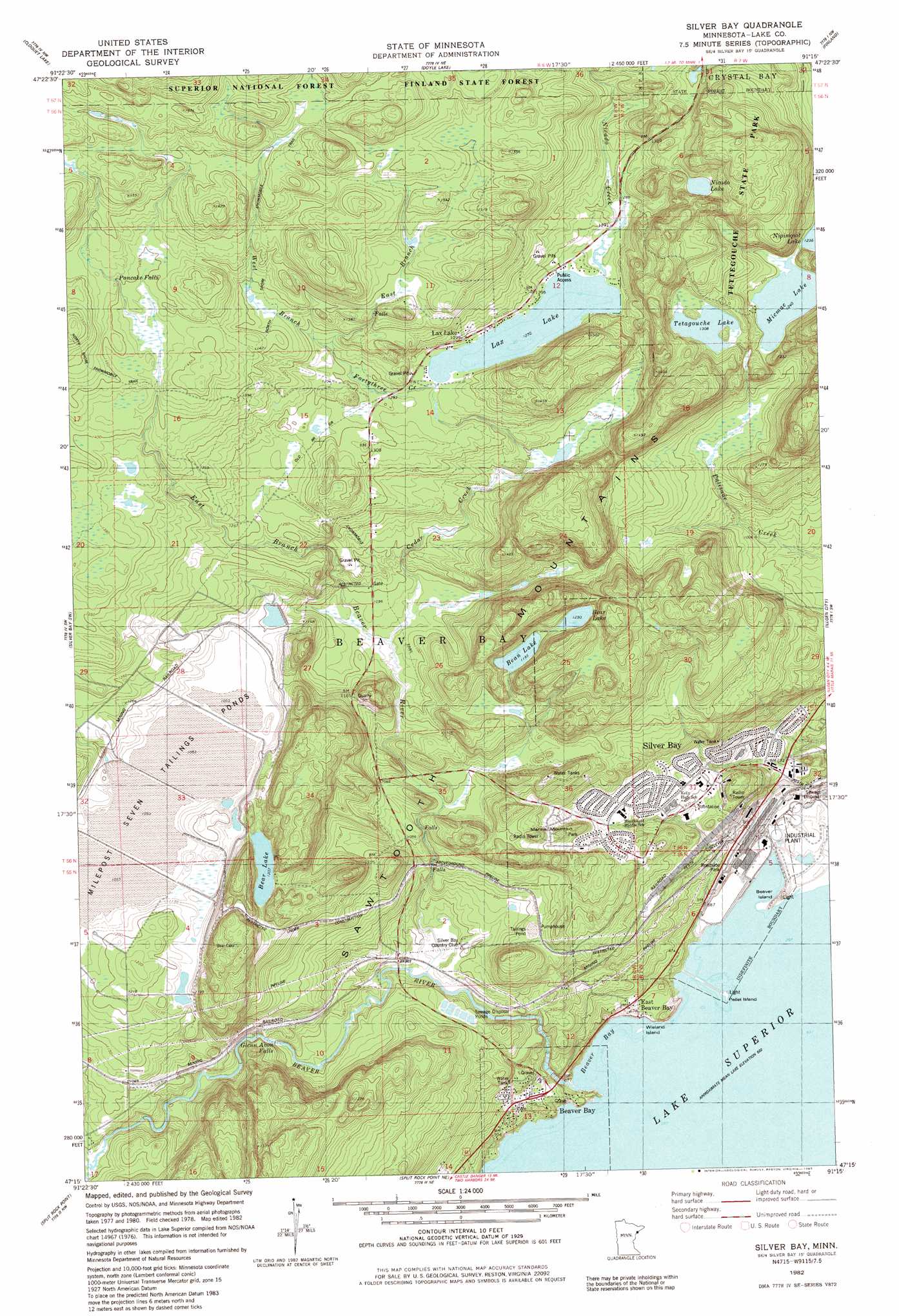
Silver Bay Topo Map Minnesota
To zoom in, hover over the map of Silver Bay
USGS Topo Quad 47091c3 - 1:24,000 scale
| Topo Map Name: | Silver Bay |
| USGS Topo Quad ID: | 47091c3 |
| Print Size: | ca. 21 1/4" wide x 27" high |
| Southeast Coordinates: | 47.25° N latitude / 91.25° W longitude |
| Map Center Coordinates: | 47.3125° N latitude / 91.3125° W longitude |
| U.S. State: | MN |
| Filename: | o47091c3.jpg |
| Download Map JPG Image: | Silver Bay topo map 1:24,000 scale |
| Map Type: | Topographic |
| Topo Series: | 7.5´ |
| Map Scale: | 1:24,000 |
| Source of Map Images: | United States Geological Survey (USGS) |
| Alternate Map Versions: |
Silver Bay MN 1982, updated 1983 Download PDF Buy paper map Silver Bay MN 1982, updated 1985 Download PDF Buy paper map Silver Bay MN 2011 Download PDF Buy paper map Silver Bay MN 2013 Download PDF Buy paper map Silver Bay MN 2016 Download PDF Buy paper map |
| FStopo: | US Forest Service topo Silver Bay is available: Download FStopo PDF Download FStopo TIF |
1:24,000 Topo Quads surrounding Silver Bay
Greenwood Lake East |
Isabella Station |
Isabella |
Cabin Lake |
Cramer |
Whyte |
Cloquet Lake |
Doyle Lake |
Finland |
|
Legler Lake |
Silver Bay Sw |
Silver Bay |
Illgen City |
|
Two Harbors Ne |
Split Rock Point |
Split Rock Point Ne |
||
Castle Danger |
> Back to 47091a1 at 1:100,000 scale
> Back to 47090a1 at 1:250,000 scale
> Back to U.S. Topo Maps home
Silver Bay topo map: Gazetteer
Silver Bay: Bays
Beaver Bay elevation 184m 603′Silver Bay: Bridges
Silver Bay City Library elevation 282m 925′Silver Bay: Falls
Beaver River Falls elevation 228m 748′Glenn Avon Falls elevation 278m 912′
Pancake Falls elevation 441m 1446′
Silver Bay: Islands
Beaver Island elevation 197m 646′Pellet Island elevation 184m 603′
Wieland Island elevation 184m 603′
Silver Bay: Lakes
Bean Lake elevation 364m 1194′Bear Lake elevation 368m 1207′
Bear Lake elevation 375m 1230′
Lax Lake elevation 387m 1269′
Micmac Lake elevation 378m 1240′
Nicado Lake elevation 425m 1394′
Tetagouche Lake elevation 399m 1309′
Silver Bay: Parks
Tettegouche State Park elevation 452m 1482′Silver Bay: Populated Places
Beaver Bay elevation 214m 702′East Beaver Bay elevation 202m 662′
Lax Lake elevation 391m 1282′
Silver Bay elevation 233m 764′
Silver Bay: Post Offices
Beaver Bay Post Office elevation 229m 751′Lax Lake Post Office (historical) elevation 387m 1269′
Silver Bay Post Office elevation 233m 764′
Silver Bay: Reservoirs
Milepost Seven Tailings Ponds elevation 354m 1161′Silver Bay: Streams
Beaver River elevation 184m 603′Cedar Creek elevation 329m 1079′
East Branch Beaver River elevation 262m 859′
East Branch Fortythree Creek elevation 399m 1309′
Fortythree Creek elevation 364m 1194′
Little Thirtynine Creek elevation 372m 1220′
Nicado Creek elevation 388m 1272′
West Branch Beaver River elevation 317m 1040′
West Branch Fortythree Creek elevation 397m 1302′
Silver Bay: Summits
Mariner Mountain elevation 357m 1171′Silver Bay digital topo map on disk
Buy this Silver Bay topo map showing relief, roads, GPS coordinates and other geographical features, as a high-resolution digital map file on DVD: