Rattlesnake Butte Topo Map North Dakota
To zoom in, hover over the map of Rattlesnake Butte
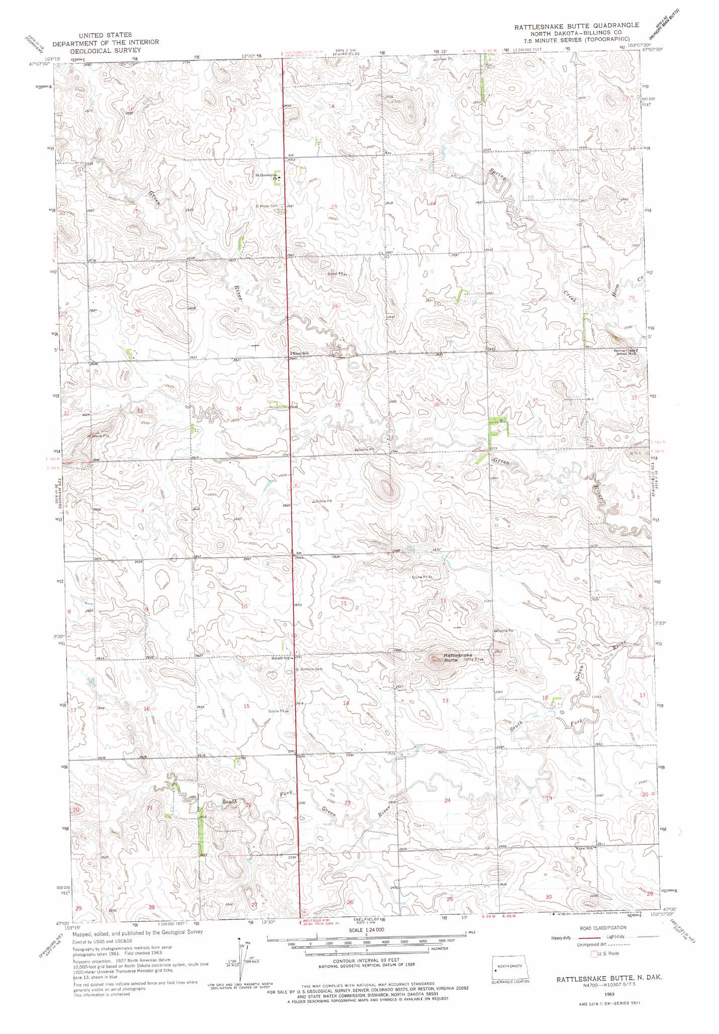
USGS Topo Quad 47103a2 - 1:24,000 scale
| Topo Map Name: | Rattlesnake Butte |
| USGS Topo Quad ID: | 47103a2 |
| Print Size: | ca. 21 1/4" wide x 27" high |
| Southeast Coordinates: | 47° N latitude / 103.125° W longitude |
| Map Center Coordinates: | 47.0625° N latitude / 103.1875° W longitude |
| U.S. State: | ND |
| Filename: | O47103A2.jpg |
| Download Map JPG Image: | Rattlesnake Butte topo map 1:24,000 scale |
| Map Type: | Topographic |
| Topo Series: | 7.5´ |
| Map Scale: | 1:24,000 |
| Source of Map Images: | United States Geological Survey (USGS) |
| Alternate Map Versions: |
Rattlesnake Butte ND 1963, updated 1964 Download PDF Buy paper map Rattlesnake Butte ND 1963, updated 1978 Download PDF Buy paper map Rattlesnake Butte ND 1997, updated 2001 Download PDF Buy paper map Rattlesnake Butte ND 2011 Download PDF Buy paper map Rattlesnake Butte ND 2014 Download PDF Buy paper map |
| FStopo: | US Forest Service topo Rattlesnake Butte is available: Download FStopo PDF Download FStopo TIF |
1:24,000 Topo Quads surrounding Rattlesnake Butte
Squaretop Butte |
Scairt Woman Draw |
Grassy Butte Sw |
Grassy Butte Se |
Fayette |
Gorham Nw |
Gorham |
Fairfield |
Hungry Man Butte |
Manning Nw |
Gorham Sw |
Gorham Se |
Rattlesnake Butte |
Fairfield Se |
New Hradec North |
Fryburg Nw |
Fryburg Ne |
Belfield |
Belfield Ne |
New Hradec South |
Tracy Mountain |
Fryburg |
Belfield Sw |
Belfield Se |
South Heart |
> Back to 47103a1 at 1:100,000 scale
> Back to 47102a1 at 1:250,000 scale
> Back to U.S. Topo Maps home
Rattlesnake Butte topo map: Gazetteer
Rattlesnake Butte: Dams
Kordonowy Dam elevation 808m 2650′Rattlesnake Butte: Streams
Horse Creek elevation 784m 2572′Rattlesnake Butte: Summits
Rattlesnake Butte elevation 843m 2765′Rattlesnake Butte digital topo map on disk
Buy this Rattlesnake Butte topo map showing relief, roads, GPS coordinates and other geographical features, as a high-resolution digital map file on DVD:
Eastern Montana & Western North Dakota
Buy digital topo maps: Eastern Montana & Western North Dakota