Lake Bowdoin Topo Map Montana
To zoom in, hover over the map of Lake Bowdoin
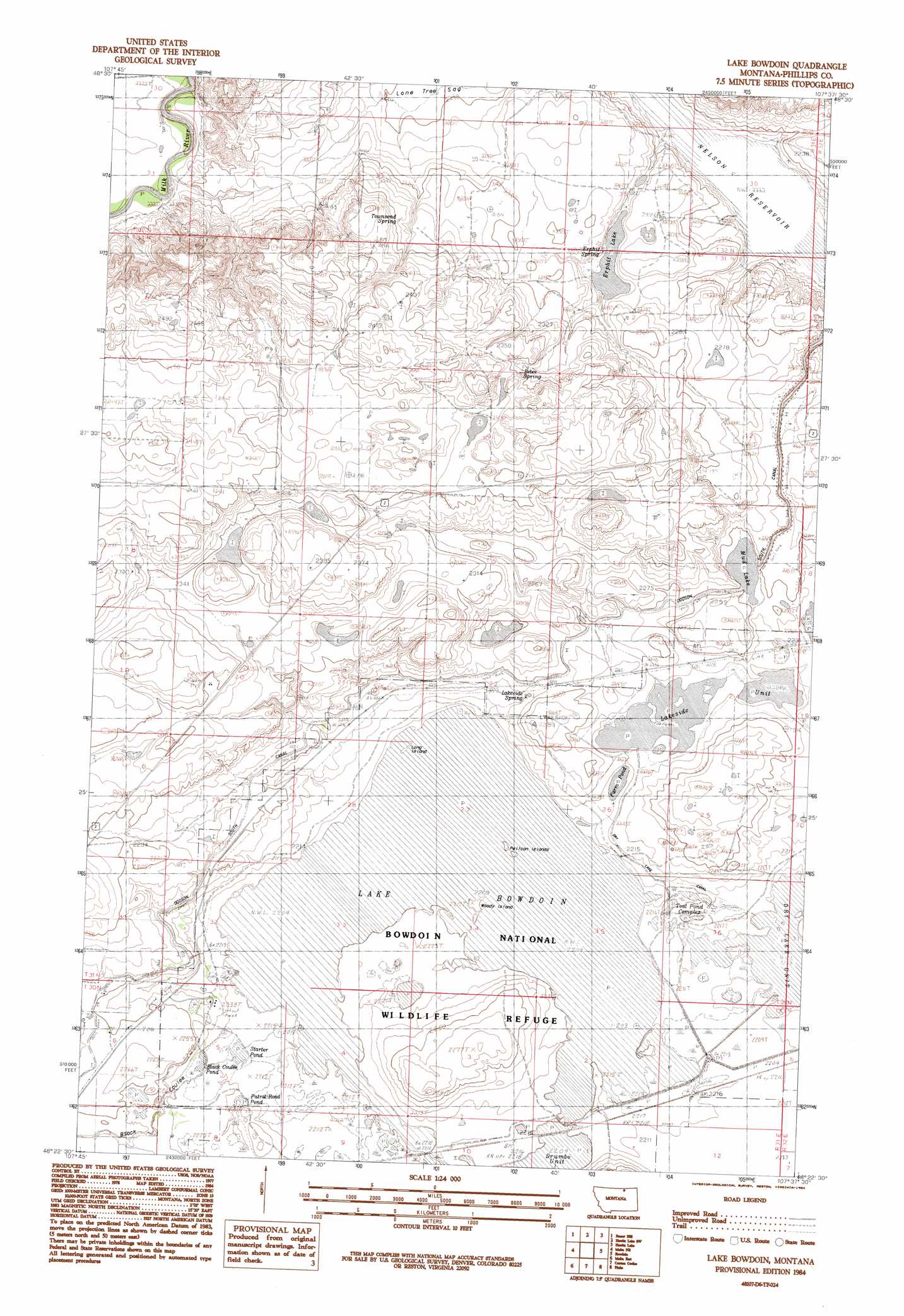
USGS Topo Quad 48107d6 - 1:24,000 scale
| Topo Map Name: | Lake Bowdoin |
| USGS Topo Quad ID: | 48107d6 |
| Print Size: | ca. 21 1/4" wide x 27" high |
| Southeast Coordinates: | 48.375° N latitude / 107.625° W longitude |
| Map Center Coordinates: | 48.4375° N latitude / 107.6875° W longitude |
| U.S. State: | MT |
| Filename: | o48107d6.jpg |
| Download Map JPG Image: | Lake Bowdoin topo map 1:24,000 scale |
| Map Type: | Topographic |
| Topo Series: | 7.5´ |
| Map Scale: | 1:24,000 |
| Source of Map Images: | United States Geological Survey (USGS) |
| Alternate Map Versions: |
Lake Bowdoin MT 1984, updated 1984 Download PDF Buy paper map Lake Bowdoin MT 2011 Download PDF Buy paper map Lake Bowdoin MT 2014 Download PDF Buy paper map |
1:24,000 Topo Quads surrounding Lake Bowdoin
Lovejoy |
Austin Coulee |
Austin Lake |
Tattnall |
Forks |
Garland Creek |
Fanny Hill |
Hewitt Lake Sw |
Hewitt Lake |
Cole |
Malta Nw |
Malta Ne |
Lake Bowdoin |
Bowdoin |
Robinson Ranch |
Malta West |
Malta East |
Clanton Coulee |
Pinks |
Regal Coulee |
Bennett Lake Nw |
Bennett Lake |
Content Nw |
Johnson Dam |
Harb |
> Back to 48107a1 at 1:100,000 scale
> Back to 48106a1 at 1:250,000 scale
> Back to U.S. Topo Maps home
Lake Bowdoin topo map: Gazetteer
Lake Bowdoin: Canals
Dry Lake Canal elevation 677m 2221′Lake Bowdoin: Islands
Long Island elevation 674m 2211′Pelican Islands elevation 674m 2211′
Woody Island elevation 675m 2214′
Lake Bowdoin: Lakes
Erphit Lake elevation 687m 2253′Lake Bowdoin elevation 674m 2211′
Lakeside Unit elevation 679m 2227′
Lone Tree Lake (historical) elevation 678m 2224′
Mud Lake elevation 685m 2247′
Lake Bowdoin: Parks
Bowdoin National Wildlife Refuge elevation 675m 2214′Lake Bowdoin: Reservoirs
Black Coulee Pond elevation 678m 2224′Farm Pond elevation 676m 2217′
Patrol Road Pond elevation 677m 2221′
Starter Pond elevation 676m 2217′
Lake Bowdoin: Springs
Bebee Spring elevation 720m 2362′Erphit Spring elevation 688m 2257′
Erphit Spring elevation 693m 2273′
Lakeside Spring elevation 682m 2237′
Lakeside_Spring elevation 683m 2240′
Townsend Spring elevation 714m 2342′
Lake Bowdoin: Swamps
Teal Pond Complex elevation 675m 2214′Lake Bowdoin: Valleys
Black Coulee elevation 683m 2240′Lake Bowdoin: Wells
31N31E22DAC_10 Well elevation 688m 2257′Lake Bowdoin digital topo map on disk
Buy this Lake Bowdoin topo map showing relief, roads, GPS coordinates and other geographical features, as a high-resolution digital map file on DVD:
Eastern Montana & Western North Dakota
Buy digital topo maps: Eastern Montana & Western North Dakota