Double S Hill Topo Map Montana
To zoom in, hover over the map of Double S Hill
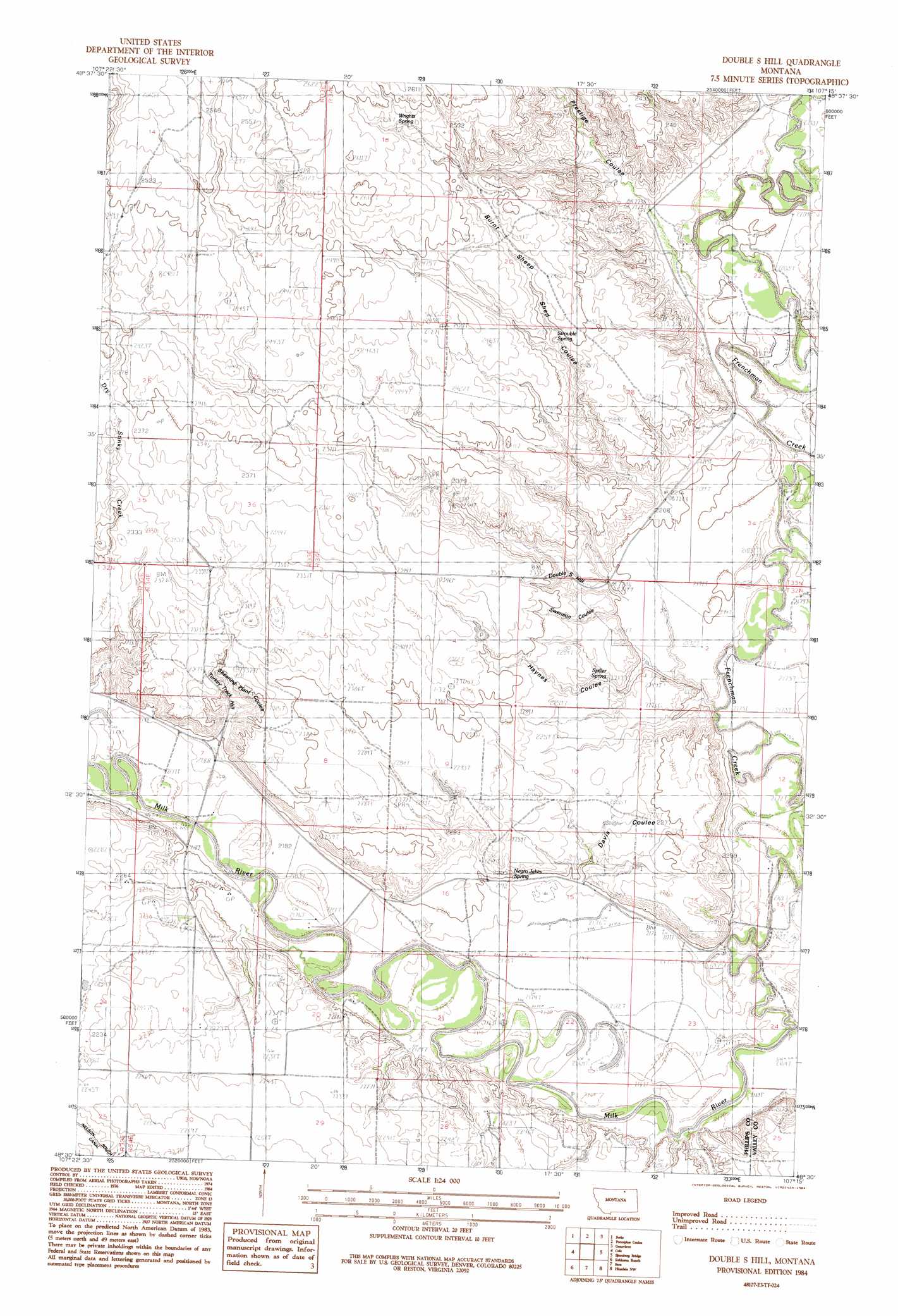
USGS Topo Quad 48107e3 - 1:24,000 scale
| Topo Map Name: | Double S Hill |
| USGS Topo Quad ID: | 48107e3 |
| Print Size: | ca. 21 1/4" wide x 27" high |
| Southeast Coordinates: | 48.5° N latitude / 107.25° W longitude |
| Map Center Coordinates: | 48.5625° N latitude / 107.3125° W longitude |
| U.S. State: | MT |
| Filename: | o48107e3.jpg |
| Download Map JPG Image: | Double S Hill topo map 1:24,000 scale |
| Map Type: | Topographic |
| Topo Series: | 7.5´ |
| Map Scale: | 1:24,000 |
| Source of Map Images: | United States Geological Survey (USGS) |
| Alternate Map Versions: |
Double S Hill MT 1984, updated 1984 Download PDF Buy paper map Double S Hill MT 2011 Download PDF Buy paper map Double S Hill MT 2014 Download PDF Buy paper map |
1:24,000 Topo Quads surrounding Double S Hill
Whitewater East |
Salsbery Reservoir |
Dead Horse Coulee |
Coulter Coulee |
Snake Creek School |
Tattnall |
Forks |
Porcupine Coulee |
Genevieve |
Papoose Hills |
Hewitt Lake |
Cole |
Double S Hill |
Bjornberg Bridge |
Jones Coulee |
Bowdoin |
Robinson Ranch |
Saco |
Hinsdale Nw |
Hinsdale |
Pinks |
Regal Coulee |
Spencer Point |
Ashford Coulee |
Hinsdale Se |
> Back to 48107e1 at 1:100,000 scale
> Back to 48106a1 at 1:250,000 scale
> Back to U.S. Topo Maps home
Double S Hill topo map: Gazetteer
Double S Hill: Dams
Gertrude Dam elevation 751m 2463′Double S Hill: Populated Places
Bone Crossing elevation 662m 2171′Jordan Crossing elevation 661m 2168′
Double S Hill: Springs
32N34E15ACD_01 Spring elevation 665m 2181′Negro Jakes Spring elevation 677m 2221′
Spiller Spring elevation 678m 2224′
Strouble Spring elevation 726m 2381′
Wrights Spring elevation 780m 2559′
Double S Hill: Streams
Frenchman Creek elevation 662m 2171′Double S Hill: Summits
Double S Hill elevation 709m 2326′Turkey Track Hill elevation 708m 2322′
Double S Hill: Valleys
Burnt Sheep Shed Coulee elevation 671m 2201′Davis Coulee elevation 670m 2198′
Haynes Coulee elevation 667m 2188′
Prestige Coulee elevation 672m 2204′
Shearing Plant Coulee elevation 669m 2194′
Swenson Coulee elevation 672m 2204′
Terrells Coulee elevation 670m 2198′
Double S Hill: Wells
32N34E07DCC_01 Well elevation 665m 2181′Double S Hill digital topo map on disk
Buy this Double S Hill topo map showing relief, roads, GPS coordinates and other geographical features, as a high-resolution digital map file on DVD:
Eastern Montana & Western North Dakota
Buy digital topo maps: Eastern Montana & Western North Dakota