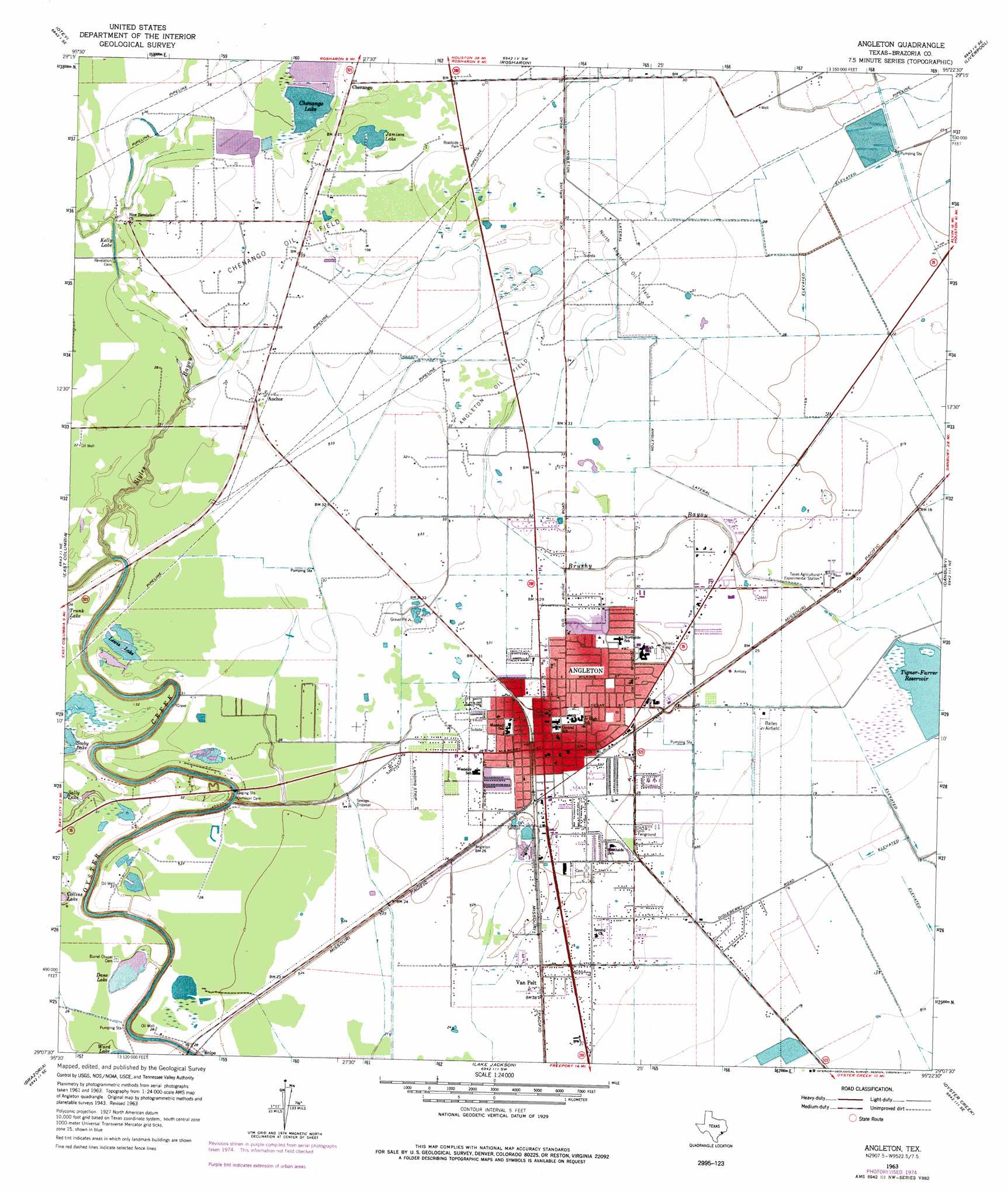
Angleton Topo Map Texas
To zoom in, hover over the map of Angleton
USGS Topo Quad 29095b4 - 1:24,000 scale
| Topo Map Name: | Angleton |
| USGS Topo Quad ID: | 29095b4 |
| Print Size: | ca. 21 1/4" wide x 27" high |
| Southeast Coordinates: | 29.125° N latitude / 95.375° W longitude |
| Map Center Coordinates: | 29.1875° N latitude / 95.4375° W longitude |
| U.S. State: | TX |
| Filename: | o29095b4.jpg |
| Download Map JPG Image: | Angleton topo map 1:24,000 scale |
| Map Type: | Topographic |
| Topo Series: | 7.5´ |
| Map Scale: | 1:24,000 |
| Source of Map Images: | United States Geological Survey (USGS) |
| Alternate Map Versions: |
Angleton TX 1943, updated 1958 Download PDF Buy paper map Angleton TX 1963, updated 1966 Download PDF Buy paper map Angleton TX 1963, updated 1975 Download PDF Buy paper map Angleton TX 1963, updated 1977 Download PDF Buy paper map Angleton TX 2010 Download PDF Buy paper map Angleton TX 2013 Download PDF Buy paper map Angleton TX 2016 Download PDF Buy paper map |
1:24,000 Topo Quads surrounding Angleton
Smithers Lake |
Thompsons |
Juliff |
Manvel |
Algoa |
Damon |
Otey |
Rosharon |
Liverpool |
Mustang Bayou |
West Columbia |
East Columbia |
Angleton |
Danbury |
Hoskins Mound |
Sweeny |
Brazoria |
Lake Jackson |
Oyster Creek |
Christmas Point |
Cedar Lane |
Cedar Lane Ne |
Jones Creek |
Freeport |
> Back to 29095a1 at 1:100,000 scale
> Back to 29094a1 at 1:250,000 scale
> Back to U.S. Topo Maps home
Angleton topo map: Gazetteer
Angleton: Airports
Bailes Airport elevation 6m 19′Cameron Airport elevation 8m 26′
Intermedics Heliport elevation 9m 29′
Phillips Corporation Airport elevation 9m 29′
Angleton: Canals
Angleton Lateral elevation 11m 36′Angleton: Dams
Coale Dam elevation 4m 13′Hudeck Reservoir Levee elevation 7m 22′
Angleton: Lakes
Chenango Lake elevation 9m 29′Dane Lake elevation 8m 26′
Jamison Lake elevation 12m 39′
Kelly Lake elevation 9m 29′
Lewis Lake elevation 9m 29′
Angleton: Oilfields
Angleton Oil Field elevation 10m 32′Chenango Oil Field elevation 12m 39′
North Angleton Oil Field elevation 11m 36′
Angleton: Parks
Angleton Independent School District Wildcat Stadium elevation 8m 26′Rueben Welch Park elevation 6m 19′
Angleton: Populated Places
Angleton elevation 9m 29′Van Pelt elevation 8m 26′
Angleton: Reservoirs
Coale Lake elevation 4m 13′Hudeck Reservoir elevation 7m 22′
Angleton: Streams
Styles Bayou elevation 4m 13′Angleton digital topo map on disk
Buy this Angleton topo map showing relief, roads, GPS coordinates and other geographical features, as a high-resolution digital map file on DVD: