Kingsland Ne Topo Map Georgia
To zoom in, hover over the map of Kingsland Ne
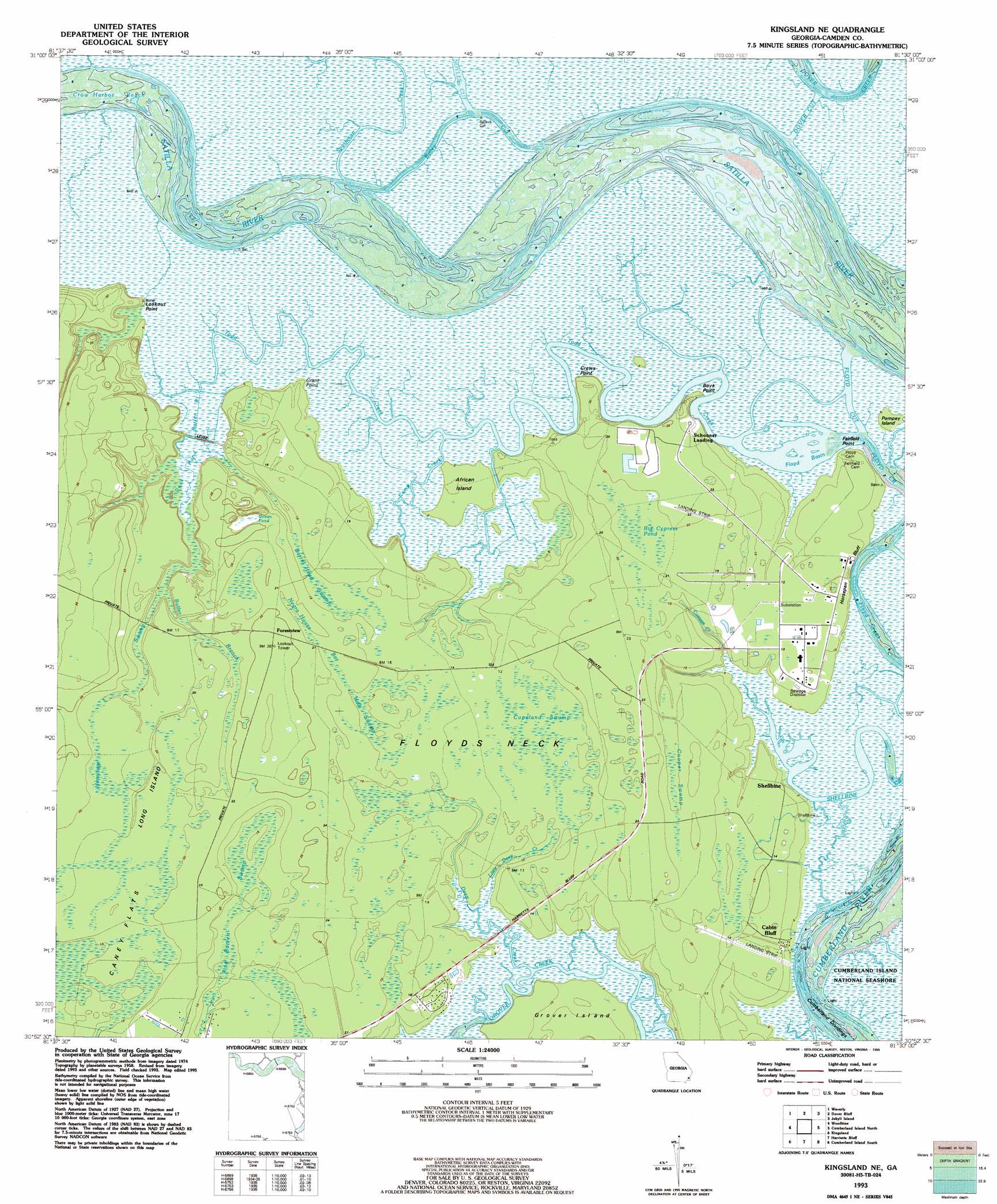
USGS Topo Quad 30081h5 - 1:24,000 scale
| Topo Map Name: | Kingsland Ne |
| USGS Topo Quad ID: | 30081h5 |
| Print Size: | ca. 21 1/4" wide x 27" high |
| Southeast Coordinates: | 30.875° N latitude / 81.5° W longitude |
| Map Center Coordinates: | 30.9375° N latitude / 81.5625° W longitude |
| U.S. State: | GA |
| Filename: | o30081h5.jpg |
| Download Map JPG Image: | Kingsland Ne topo map 1:24,000 scale |
| Map Type: | Topographic |
| Topo Series: | 7.5´ |
| Map Scale: | 1:24,000 |
| Source of Map Images: | United States Geological Survey (USGS) |
| Alternate Map Versions: |
Kingsland NE GA 1958, updated 1959 Download PDF Buy paper map Kingsland NE GA 1979, updated 1980 Download PDF Buy paper map Kingsland NE GA 1993, updated 1995 Download PDF Buy paper map Kingsland NE GA 2011 Download PDF Buy paper map Kingsland NE GA 2014 Download PDF Buy paper map |
1:24,000 Topo Quads surrounding Kingsland Ne
Waynesville |
Bladen |
Brunswick West |
Brunswick East |
Sea Island |
Tarboro |
Waverly |
Dover Bluff |
Jekyll Island |
|
Jerusalem |
Woodbine |
Kingsland Ne |
Cumberland Island North |
|
Kings Ferry |
Kingsland |
Harrietts Bluff |
Cumberland Island South |
|
Hilliard Ne |
Gross |
Saint Marys |
Fernandina Beach |
> Back to 30081e1 at 1:100,000 scale
> Back to 30080a1 at 1:250,000 scale
> Back to U.S. Topo Maps home
Kingsland Ne topo map: Gazetteer
Kingsland Ne: Airports
Union Carbide Plant Strip elevation 6m 19′Kingsland Ne: Basins
Floyd Basin elevation 0m 0′Kingsland Ne: Capes
Boys Point elevation 1m 3′Crews Point elevation 7m 22′
Fairfield Point elevation 2m 6′
Floyds Neck elevation 3m 9′
Grants Point elevation 1m 3′
Lookout Point elevation 2m 6′
Kingsland Ne: Channels
Bailey Cut elevation 1m 3′Cumberland Dividings elevation 0m 0′
Cumberland River elevation 0m 0′
Dover Cut elevation 0m 0′
Floyd Creek elevation 0m 0′
Floyd Cut elevation 0m 0′
Noyles Cut elevation 0m 0′
The Bulkhead elevation 0m 0′
Kingsland Ne: Cliffs
Horsepen Bluff elevation 2m 6′Kingsland Ne: Flats
Caney Flats elevation 5m 16′Kingsland Ne: Guts
Grover Creek elevation 0m 0′Kingsland Ne: Islands
African Island elevation 1m 3′Grover Island elevation 3m 9′
Long Island elevation 6m 19′
Pompey Island elevation 1m 3′
Kingsland Ne: Lakes
Ocean Pond elevation 4m 13′Kingsland Ne: Populated Places
Bell View (historical) elevation 4m 13′Cabin Bluff elevation 1m 3′
Forestview elevation 8m 26′
Grover View elevation 4m 13′
Shellbine elevation 2m 6′
Kingsland Ne: Streams
Butler Branch elevation 1m 3′Camp Creek elevation 0m 0′
Cottage Creek elevation 1m 3′
Deep Creek elevation 1m 3′
Sparkman Creek elevation 0m 0′
Todd Creek elevation 0m 0′
Kingsland Ne: Swamps
Barrel Head Swamp elevation 4m 13′Big Cypress Pond elevation 5m 16′
Cooper Swamp elevation 4m 13′
Copeland Swamp elevation 4m 13′
Duck Pond elevation 1m 3′
Halls Swamp elevation 4m 13′
Hermitage Swamp elevation 6m 19′
Negro House Bay elevation 6m 19′
Pine Barren Swamp elevation 4m 13′
Kingsland Ne digital topo map on disk
Buy this Kingsland Ne topo map showing relief, roads, GPS coordinates and other geographical features, as a high-resolution digital map file on DVD: